
-
Federal
TIGER/Line Shapefile, 2019, nation, U.S., Primary Roads National Shapefile NGDA
U.S. Census Bureau, Department of Commerce —
The TIGER/Line shapefiles and related database files (.dbf) are an extract of selected geographic and cartographic information from the U.S. Census Bureau's Master... -
Federal
High Tide Flooding Products from NOAA CO-OPS
National Oceanic and Atmospheric Administration, Department of Commerce —
High tide flooding is the overflow or excess accumulation of water that covers typically dry coastal land and occurs during high tides. As relative sea levels rise,... -
Federal
Collection TIGER/Line Shapefile, 2015, Series Information for the 2015 TIGER/Line Shapefile All Roads County-based Shapefile
U.S. Census Bureau, Department of Commerce —
The All Roads Shapefile includes all features within the MTDB Super Class "Road/Path Features" distinguished where the MAF/TIGER Feature Classification Code (MTFCC)... -
Federal
Last of the Wild Project, Version 2, 2005 (LWP-2): Global Human Footprint Dataset (Geographic)
National Aeronautics and Space Administration —
The Global Human Footprint Dataset of the Last of the Wild Project, Version 2, 2005 (LWP-2) is the Human Influence Index (HII) normalized by biome and realm. The HII... -
Federal
TIGER/Line Shapefile, 2016, nation, U.S., Primary Roads National Shapefile
U.S. Census Bureau, Department of Commerce —
The TIGER/Line shapefiles and related database files (.dbf) are an extract of selected geographic and cartographic information from the U.S. Census Bureau's Master... -
Federal
F00625: NOS Hydrographic Survey , Hampton Roads, Virginia, 2012-11-01
National Oceanic and Atmospheric Administration, Department of Commerce —
The National Oceanic and Atmospheric Administration (NOAA) has the statutory mandate to collect hydrographic data in support of nautical chart compilation for safe... -
Federal
H09299: NOS Hydrographic Survey , Off Sapelo Sound to Tybee Roads, Georgia-South Carolina, 1972-04-27
National Oceanic and Atmospheric Administration, Department of Commerce —
The National Oceanic and Atmospheric Administration (NOAA) has the statutory mandate to collect hydrographic data in support of nautical chart compilation for safe... -
Federal
D00159: NOS Hydrographic Survey , 2011-08-30
National Oceanic and Atmospheric Administration, Department of Commerce —
The National Oceanic and Atmospheric Administration (NOAA) has the statutory mandate to collect hydrographic data in support of nautical chart compilation for safe... -
Federal
Last of the Wild Project, Version 2, 2005 (LWP-2): Global Human Influence Index (HII) Dataset (IGHP)
National Aeronautics and Space Administration —
The Global Human Influence Index Dataset of the Last of the Wild Project, Version 2, 2005 (LWP-2) is a global dataset of 1-kilometer grid cells, created from nine... -
Federal
TIGER/Line Shapefile, 2017, nation, U.S., Primary Roads National Shapefile
U.S. Census Bureau, Department of Commerce —
The TIGER/Line shapefiles and related database files (.dbf) are an extract of selected geographic and cartographic information from the U.S. Census Bureau's Master... -
Federal
H13828: NOS Hydrographic Survey , 2024-06-03
National Oceanic and Atmospheric Administration, Department of Commerce —
The National Oceanic and Atmospheric Administration (NOAA) has the statutory mandate to collect hydrographic data in support of nautical chart compilation for safe... -
Federal
Daily surface water temperature data collected from bucket casts from pier at Leigh Marine Laboratory, Auckland, New Zealand from 1967-01-01 to 2011-04-30 (NCEI Accession 0127323)
National Oceanic and Atmospheric Administration, Department of Commerce —
Collected seawater temperatures at the Leigh Marine Laboratory. Dataset contains an archive of material to 2011. The location of the laboratory is lat: -36.26929,... -
Federal
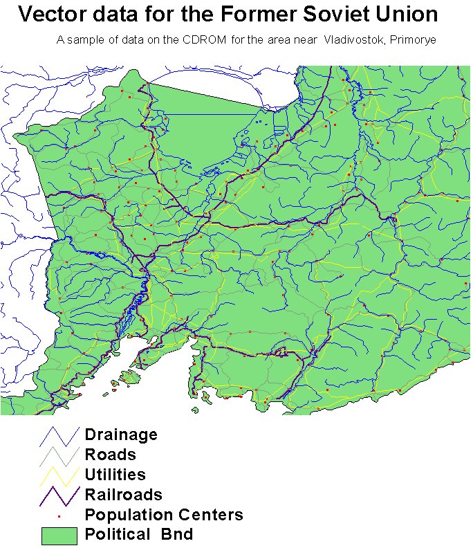
RLC Selected Infrastructure Data for the Former Soviet Union, 1993
National Aeronautics and Space Administration —
This data set consists of roads, drainage, railroads, utilities, and population center information in readily usable vector format for the land area of the Former... -
Federal
H03788A: NOS Hydrographic Survey
National Oceanic and Atmospheric Administration, Department of Commerce —
The National Oceanic and Atmospheric Administration (NOAA) has the statutory mandate to collect hydrographic data in support of nautical chart compilation for safe... -
Federal
Last of the Wild Project, Version 2, 2005 (LWP-2): Global Human Footprint Dataset (IGHP)
National Aeronautics and Space Administration —
The Global Human Footprint Dataset of the Last of the Wild Project, Version 2, 2005 (LWP-2) is the Human Influence Index (HII) normalized by biome. The HII is a... -
Federal
KILINI CREEK AT TWP ROAD NO 543
National Oceanic and Atmospheric Administration, Department of Commerce —
Timeseries data from 'KILINI CREEK AT TWP ROAD NO 543' (ca_hydro_05EA013) -
Federal
WEST ROAD RIVER NEAR CINEMA
National Oceanic and Atmospheric Administration, Department of Commerce —
Timeseries data from 'WEST ROAD RIVER NEAR CINEMA' (ca_hydro_08KG001) -
Federal
Salmon Creek at Salmon Creek Road
National Oceanic and Atmospheric Administration, Department of Commerce —
Timeseries data from 'Salmon Creek at Salmon Creek Road' (gov_noaa_water_smna2) -
Federal
LBA-ECO CD-06 Physical, Political, and Hydrologic Maps, Ji-Parana River Basin, Brazil
National Aeronautics and Space Administration —
This data set contains physical, hydrologic, political, demographic, and societal maps for the Ji-Parana River Basin, in the state of Rondonia, Brazil. These data... -
Federal
LBA-ECO LC-14 Modeled Deforestation Scenarios, Amazon Basin: 2002-2050
National Aeronautics and Space Administration —
This data set provides the results of the two modeled scenarios for future patterns of deforestation across the Amazon Basin from 2002 to 2050. This larger defined...

Official websites use .gov
A
.gov website belongs to an official government
organization in the United States.
Secure .gov websites use HTTPS
A
lock (
) or https:// means you’ve safely connected to
the .gov website. Share sensitive information only on official,
secure websites.
.jpg)