
-
Federal
Characterization data on the effects of micro-computed tomography-based x-ray radiation on vinyl nitrile foam
Department of Commerce —
This dataset contains information from investigating the effects of micro-computed tomographic imaging irradiation on vinyl nitrile foam and code for a finite element... -
Federal
Characterization data on the effects of micro-computed tomography-based x-ray radiation on vinyl nitrile foam
National Institute of Standards and Technology —
This dataset contains information from investigating the effects of micro-computed tomographic imaging irradiation on vinyl nitrile foam and code for a finite element... -
Federal
ASTER L2 Surface Radiance TIR V003
National Aeronautics and Space Administration —
The Terra Advanced Spaceborne Thermal Emission and Reflection Radiometer (ASTER) Surface Radiance TIR (AST_09T) is generated using the five Thermal Infrared (TIR)... -
Federal
NARSTO PAC2001 Langley Site Gaseous, Particle, and Meteorological Data
National Aeronautics and Space Administration —
NARSTO_PAC2001_LANGLEY_GAS_PM_MET_DATA was obtained between August 8 and September 2, 2001 during the Pacific 2001 Air Quality Study (PAC2001).The Langley Ecole... -
Federal
Global Gridded Soil Phosphorus Distribution Maps at 0.5-degree Resolution
National Aeronautics and Space Administration —
This data set provides estimates of different forms of naturally occurring soil phosphorus (P) including labile inorganic P, organic P, occluded P, secondary mineral... -
Federal
LBA-ECO CD-17 Secondary Forest Survey, Para and Rondonia, Brazil: 2002-2003
National Aeronautics and Space Administration —
This data set provides measurements for diameter at breast height (DBH), tree height, distance from tree stems to the furthest canopy element, and a species survey of... -
Federal
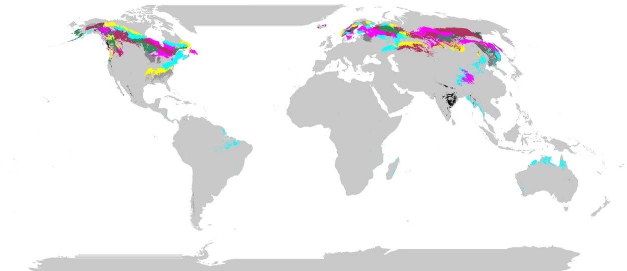
Phenoregions For Monitoring Vegetation Responses to Climate Change
National Aeronautics and Space Administration —
The overall purpose in this research was to identify the regions of the world best suited for long-term monitoring of biospheric responses to climate change, i.e.... -
Federal
CG 12 Chandra X-Ray Point Source Catalog
National Aeronautics and Space Administration —
The mysterious high Galactic latitude cometary globule CG 12 has been observed with the ACIS detector on board the Chandra X-Ray Observatory. 128 X-ray sources are... -
Federal
MESSENGER Magnetometer (MAG) Interplanetary Magnetic Field, Radial-Tangential-Normal, RTN, Coordinates, High Resolution, 1 s Data
National Aeronautics and Space Administration —
This MESSENGER Magnetic field data set contains cruise-phase magnetic field vectors in RTN coordinates at time resolutions typically of 0.5 s or 1.0 s and sometimes... -
Federal
DSCOVR EPIC Level 4 Tropospheric Ozone
National Aeronautics and Space Administration —
EPIC Tropospheric Ozone Data ProductThe Earth Polychromatic Imaging Camera (EPIC) on the Deep Space Climate Observatory (DSCOVR) spacecraft provides measurements of... -
Federal
Methane Plumes Derived from AVIRIS-NG over Point Sources across California, 2016-2017
National Aeronautics and Space Administration —
This dataset provides maps of methane (CH4) plumes along flight lines over identified methane point-source emitting infrastructure across the State of California, USA... -
Federal
Airborne Multi-angle Imaging SpectroRadiometer (AirMISR) Data from the SERC 2003 Campaign
National Aeronautics and Space Administration —
The AIRMISR_SERC_2003 data were acquired during a flight over the Smithsonian Environmental Research Center, Maryland, USA, target as part of the AirMISR deployments... -
Federal
Biodiversity Survey of the Cape - Mapping Dissolved Organic Carbon sources and cycling in aquatic biodiversity hotspots across South Africa's Greater Cape Floristic Region
National Aeronautics and Space Administration —
This dataset includes the spectral (absorption and fluorescence) characteristics of colored dissolved organic matter (CDOM) coincident with field measurements of... -
Federal
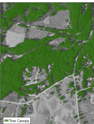
CMS: Tree Canopy Cover at 0.5-meter resolution, Vermont, 2016
National Aeronautics and Space Administration —
This dataset contains estimates of tree canopy cover presence at high resolution (0.5m) across the state of Vermont for 2016 in Cloud-Optimized GeoTIFF (*.tif)... -
Federal
Airborne Multi-angle Imaging SpectroRadiometer (AirMISR) Data from the Bartlett 2003 Campaign
National Aeronautics and Space Administration —
The AIRMISR_BARTLETT_2003 data were acquired during a flight over the Bartlett Experimental Forest, New Hampshire, USA, target as part of the AirMISR deployments from... -
Federal
Airborne Multi-angle Imaging SpectroRadiometer (AirMISR) Data from the Morgan Monore 2003 Campaign
National Aeronautics and Space Administration —
The AIRMISR_MORGAN_MONROE_2003 data were acquired during a flight over the Morgan Monroe State Forest, Indiana, USA, target as part of the AirMISR deployments from... -
Federal
LBA Regional Land Cover from AVHRR, 1-km, Version 1.2 (IGBP)
National Aeronautics and Space Administration —
The data set consists of a LBA study area subset of the IGBP DISCover Data Set. The DISCover data set is one data set contained within the Global Land Cover... -
Federal
SAFARI 2000 Cloud Physics Lidar (CPL) Quicklook Images and Maps
National Aeronautics and Space Administration —
The effect of clouds and aerosols on regional and global climate is of great importance. Two longstanding elements of the NASA climate and radiation science program... -
Federal
Airborne Multi-angle Imaging SpectroRadiometer (AirMISR) Data from the Harvard 2003 Campaign
National Aeronautics and Space Administration —
The AIRMISR_HARVARD_2003 data set was acquired during a flight over the Harvard Forest, Massachusetts, USA, target as part of the AirMISR deployments from the Wallops...

Official websites use .gov
A
.gov website belongs to an official government
organization in the United States.
Secure .gov websites use HTTPS
A
lock (
) or https:// means you’ve safely connected to
the .gov website. Share sensitive information only on official,
secure websites.