
-
Federal
2018 - 2020 NOAA USGS Lidar: Hawaii, HI
National Oceanic and Atmospheric Administration, Department of Commerce —
Product: Processed, classified lidar point cloud data tiles in LAS 1.4 format. Geographic Extent: Approximately 4,028 square miles encompassing the Big Island of... -
Federal
Gridded bathymetry of Kaneohe Bay, Windward Side Oahu, Main Hawaiian Islands, USA.
National Oceanic and Atmospheric Administration, Department of Commerce —
4-m grid of bathymetric data of Kaneohe Bay, Windward Side Oahu, Main Hawaiian Islands, USA. These netCDF and ASCII grids include multibeam bathymetry from the Reson... -
Federal
2017 NOAA/MCP Topobathy Lidar: Blue Hill Bay, ME - SHOALS Sensor
National Oceanic and Atmospheric Administration, Department of Commerce —
Fugro was contracted in July 2017 by the State of Maine Department of Marine Resources (SMDMR), Maine Coastal Program (MCP), and the NOAA Office for Coastal... -
Federal
Maui LiDAR
Department of Energy —
Light Detection and Ranging (LiDAR) data for the Maui study area in South Maui, collected by Watershed Sciences, Inc. (WS) on October 29th, 2011 and from November... -
Federal
NOAA Geotiff - 5 meter LiDAR Reflectivity, U.S. Caribbean - Puerto Rico (southwest) - Projects OPR-I305-KRL-06, (2006), UTM 19N NAD83
National Oceanic and Atmospheric Administration, Department of Commerce —
This image represents a LiDAR (Light Detection and Ranging) intensity mosaic (mean 5 meter gridded) from the shoreline of southwestern Puerto Rico to about 50 meters... -
Federal
LiDAR - White River National Wildlife Refuge
Department of the Interior —
LiDAR geospatial data were collected on approximately 60,000 acres of White River National Wildlife Refuge in late fall-winter 2016-17. The associated deliverables... -
Federal
Data from: Efficient imaging and computer vision detection of two cell shapes in young cotton fibers
Department of Agriculture —
Methods Cotton plants were grown in a well-controlled greenhouse in the NC State Phytotron as described previously (Pierce et al, 2019). Flowers were tagged on the... -
Federal
EnviroAtlas -- Memphis, Tennessee -- Meter-Scale Urban Land Cover (MULC) Data (2012)
U.S. Environmental Protection Agency —
The Memphis, TN EnviroAtlas One Meter-scale Urban Land Cover (MULC) dataset comprises 2,733 km2 around the city of Memphis, surrounding towns, and rural areas. These... -
Federal
NOAA Geotiff - 4 meter LiDAR bathymetry, U.S. Caribbean - Puerto Rico (southwest) - Projects OPR-I305-KRL-06, (2006), UTM 19N NAD83
National Oceanic and Atmospheric Administration, Department of Commerce —
This image represents a LiDAR (Light Detection and Ranging) bathymetric mosaic (mean 4 meter gridded) collected along the coastline of southwestern Puerto Rico. The... -
Federal
NOAA Geotiff - 5 meter LiDAR Reflectivity, U.S. Caribbean - Puerto Rico (southwest) - Projects OPR-I305-KRL-06, (2006), UTM 19N NAD83
National Oceanic and Atmospheric Administration, Department of Commerce —
This image represents a LiDAR (Light Detection and Ranging) intensity mosaic (mean 5 meter gridded) from the shoreline of southwestern Puerto Rico to about 50 meters... -
Federal
2017 NOAA/MCP Topobathy Lidar DEM: Blue Hill Bay, ME - SHOALS Sensor
National Oceanic and Atmospheric Administration, Department of Commerce —
Fugro was contracted in July 2017 by the State of Maine Department of Marine Resources (SMDMR), Maine Coastal Program (MCP), and the NOAA Office for Coastal... -
Federal
LiDAR Derived Bare Earth Digital Elevation Model, 2016: Minidoka National Wildlife Refuge
Department of the Interior —
This lidar data set includes unclassified swath LAS 1.4 files, classified LAS 1.4 files, breaklines, digital elevation models (DEMs), first return digital surface... -
Federal
Wind Profile Data: LIDAR - NOAA (FIFE)
National Aeronautics and Space Administration —
The aim of this wind profile study was to derive wind profiles and momentum fluxes from the National Oceanic and Atmospheric Administration (NOAA)/Wave Propagation... -
Federal
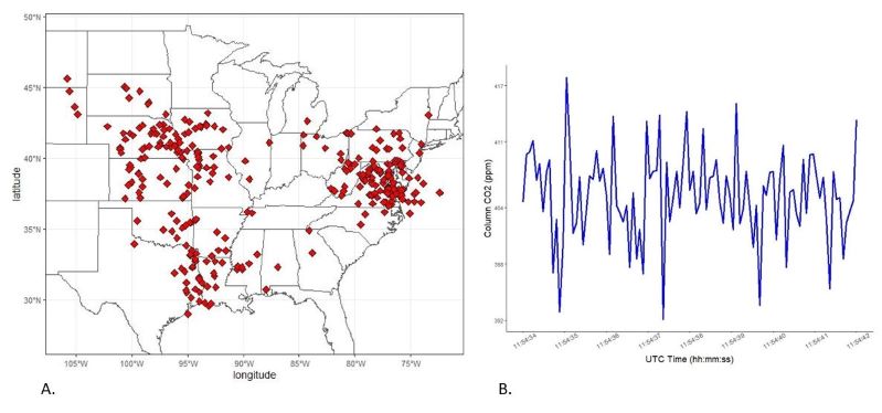
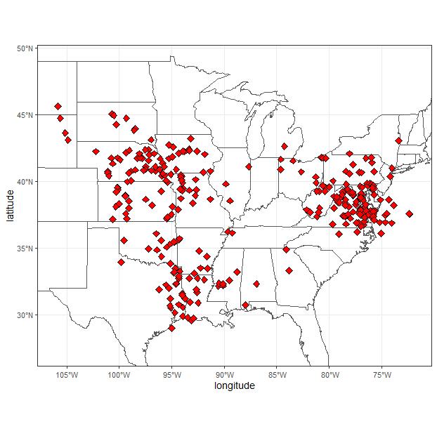
ACT-America: L2 Remotely Sensed Column-avg CO2 by Airborne Lidar, Lite, Eastern USA
National Aeronautics and Space Administration —
This dataset provides a direct subset (i.e., the Lite version) of the Level 2 (L2) remotely sensed column-average carbon dioxide (CO2) concentrations measured during... -
Federal
Digital Elevation Models for the Global Change Research Wetland, Maryland, USA, 2016
National Aeronautics and Space Administration —
This dataset contains four alternative digital elevation models (DEMs) at 1 m resolution and model performance statistical metrics for the Global Change Research... -
Federal
ACT-America: L2 Weighting Functions for Airborne Lidar Column-avg CO2, Eastern USA
National Aeronautics and Space Administration —
This dataset provides vertical weighting function coefficients of the Level 2 (L2) remotely sensed column-average carbon dioxide (CO2) concentrations measured during... -
Federal
Geospatial data for the Vegetation Mapping Inventory Project of Lewis and Clark National Historical Park
Department of the Interior —
The files linked to this reference are the geospatial data created as part of the completion of the baseline vegetation inventory project for the NPS park unit.... -
Federal
Imagery data for the Vegetation Mapping Inventory Project of Biscayne National Park
Department of the Interior —
This reference contains the imagery data used in the completion of the baseline vegetation inventory project for the NPS park unit. Orthophotos, raw imagery, and... -
Federal
ATom: Light-Absorbing Metallic Aerosols, Single Particle Soot Photometer, 2016-2018
National Aeronautics and Space Administration —
This dataset provides mass mixing ratios and number density of light-absorbing metallic aerosols (LAM) in the size range 180-1290 nm obtained with the NOAA Single... -
Federal
NOAA Geotiff - 4 meter LiDAR bathymetry, U.S. Caribbean - Puerto Rico (southwest) - Projects OPR-I305-KRL-06, (2006), UTM 19N NAD83
National Oceanic and Atmospheric Administration, Department of Commerce —
This image represents a LiDAR (Light Detection and Ranging) bathymetric mosaic (mean 4 meter gridded) collected along the coastline of southwestern Puerto Rico. The...

Official websites use .gov
A
.gov website belongs to an official government
organization in the United States.
Secure .gov websites use HTTPS
A
lock (
) or https:// means you’ve safely connected to
the .gov website. Share sensitive information only on official,
secure websites.