
-
Federal
Aviation Facilities
Federal Geographic Data Committee —
The Aviation Facilities dataset is updated every 28 days from the Federal Aviation Administration (FAA) and is part of the U.S. Department of Transportation... -
Federal
BLM OR Remote Sensing Satellite Project Polygon Hub
Department of the Interior —
SATELLITE_PROJECT_POLY: Merged individual polygons from Satellite_Project_Poly for the area of BLM lands in Oregon and Washington. -
Federal
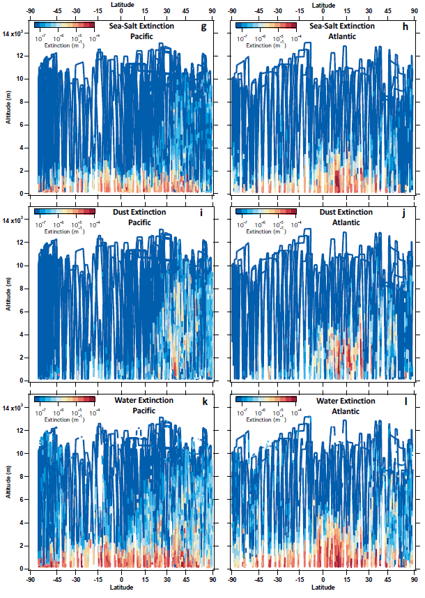
ATom: Dominant Role of Mineral Dust in Cirrus Cloud Formation
National Aeronautics and Space Administration —
This dataset provides: (1) In situ dust aerosol concentration measurements over remote tropical Pacific and Atlantic Oceans by NOAA Particle Analysis by Laser Mass... -
Federal
Aerial Survey Counts of Harbor Seals in Coastal Alaska (1998-2002)
National Oceanic and Atmospheric Administration, Department of Commerce —
This dataset supports efforts to estimate the abundance and trends in population size of Alaska harbor seals. Annual surveys of harbor seal populations are... -
Federal
Aerial Survey Counts of Harbor Seals in Coastal Alaska (2003-2011)
National Oceanic and Atmospheric Administration, Department of Commerce —
This dataset supports efforts to estimate the abundance and trends in population size of Alaska harbor seals. Annual surveys of harbor seal populations are... -
Federal
BLM OR Aerial Photography Center Point Hub
Department of the Interior —
AP_CENTER_POINT: This data depicts the center points of aerial photographs of BLM lands in Oregon and Washington.. -
Federal
BLM OR Aerial Photography Footprint Polygon Hub
Department of the Interior —
AP_FOOTPRINT_POLY: Data consists of polygons depicting the spatial footprints of individual aerial photographs on BLM lands in Oregon and Washington. -
Federal
Molecular detection of Coccidioides sp. spores in arid soils and UAS-enabled bioaerosol collection in the San Joaquin Valley, 2024
U.S. Environmental Protection Agency —
The goal of this study is to determine if there is an association between aerosolized particulate matter (PM) density, wind speed, temperature, humidity, soil-... -
Federal
Western North American FLEXPART Back Trajectory 2000 Data
National Aeronautics and Space Administration —
WNA-FLEXPART-BackTraj-2000 is the 2000 Western North America Back Trajectory data using the FLEXible PARTicle (FLEXPART) dispersion model. Data collection for this... -
Federal
Western North American FLEXPART Back Trajectory 2007 Data
National Aeronautics and Space Administration —
WNA-FLEXPART-BackTraj-2007 is the 2007 Western North America Back Trajectory data using the FLEXible PARTicle (FLEXPART) dispersion model. Data collection for this... -
Federal
The effects of advanced spectral line shapes on atmospheric carbon dioxide retrievals
National Institute of Standards and Technology —
This is the data presented in the figures of the paper "The effects of advanced spectral line shapes on atmospheric carbon dioxide retrievals" published in J. Quant.... -
Federal
BLM OR Remote Sensing Lidar Project Polygon Hub
Department of the Interior —
LIDAR_PROJECT_POLY: Data consists of polygons representing the spatial footprints of LIDAR projects over BLM lands in Oregon and Washington. -
Federal
BLM AK Easement 17(b) Point
Department of the Interior —
The ANCSA 17(b) Easement dataset represents spatial location and basic information about 17(b) easements within the state of Alaska. ANCSA 17(b) easements are rights... -
Federal
Western North American FLEXPART Back Trajectory 1999 Data
National Aeronautics and Space Administration —
WNA-FLEXPART-BackTraj-1999 is the 1999 Western North America Back Trajectory data using the FLEXible PARTicle (FLEXPART) dispersion model. Data collection for this... -
Federal
BLM AK Easement 17(b) Line
Department of the Interior —
The ANCSA 17(b) Easement dataset represents spatial location and basic information about 17(b) easements within the state of Alaska. ANCSA 17(b) easements are rights... -
Federal
ATom: Comprehensive Aerosol Properties, 2016-2018, Version 2
National Aeronautics and Space Administration —
This dataset contains comprehensive measurements of aerosol microphysical, chemical, and optical properties derived for both dry and ambient conditions from in situ... -
Federal
Data from: A pilot study for water storage and carbon variability in an irrigation pond of the Southeastern Plains, USA
Department of Agriculture —
Farm ponds are a common feature of agricultural landscapes for irrigation of crops. Yet small water bodies have been ignored as reservoirs and carbon balance features... -
Federal
Western North American FLEXPART Back Trajectory 2009 Data
National Aeronautics and Space Administration —
WNA-FLEXPART-BackTraj-2009 is the 2009 Western North America Back Trajectory data using the FLEXible PARTicle (FLEXPART) dispersion model. Data collection for this... -
Federal
Western North American FLEXPART Back Trajectory 2002 Data
National Aeronautics and Space Administration —
WNA-FLEXPART-BackTraj-2002 is the 2002 Western North America Back Trajectory data using the FLEXible PARTicle (FLEXPART) dispersion model. Data collection for this...

Official websites use .gov
A
.gov website belongs to an official government
organization in the United States.
Secure .gov websites use HTTPS
A
lock (
) or https:// means you’ve safely connected to
the .gov website. Share sensitive information only on official,
secure websites.