

24 datasets found for "9 Digit ZIP Code Centroids"
-
Federal
Solar-to-Grid Public Data File for Utility-scale (UPV) and Distributed Photovoltaics (DPV) Generation, Capacity Credit, and Value
Department of Energy —
Lawrence Berkeley National Laboratory (Berkeley Lab) estimates hourly project-level generation data for utility-scale solar projects and hourly county-level... -
Federal
Unpublished Digital Geologic Map of Chickasaw National Recreation Area and Vicinity, Oklahoma (NPS, GRD, GRI, CHIC, CHIC digital map)
Department of the Interior —
The Unpublished Digital Geologic Map of Chickasaw National Recreation Area and Vicinity, Oklahoma is composed of GIS data layers and GIS tables in a 10.0 file... -
Federal
Collection TIGER/Line Shapefile, 2019, Series Information for the Address Ranges County-based Relationship File
U.S. Census Bureau, Department of Commerce —
The TIGER/Line shapefiles and related database files (.dbf) are an extract of selected geographic and cartographic information from the U.S. Census Bureau's Master... -
Federal
LBA-ECO LC-08 Soil, Vegetation, and Land Cover Maps for Brazil and South America
National Aeronautics and Space Administration —
This data set provides (1) soil maps for Brazil that are digital versions of the MAPA DE SOLOS DO BRASIL (EMBRAPA, 1981) classified at three levels of detail,... -
Federal
Collection TIGER/Line Shapefile, 2016, Series Information for the Current Block Group State-based Shapefile
U.S. Census Bureau, Department of Commerce —
The TIGER/Line shapefiles and related database files (.dbf) are an extract of selected geographic and cartographic information from the U.S. Census Bureau's Master... -
Federal
Daily and Annual PM2.5, O3, and NO2 Concentrations at ZIP Codes for the Contiguous U.S., 2000-2016, v1.0
National Aeronautics and Space Administration —
The Daily and Annual PM2.5, O3, and NO2 Concentrations at ZIP Codes for the Contiguous U.S., 2000-2016, v1.0 data set contains daily and annual concentration... -
Federal
EGS Collab Experiment 1: Microseismic Monitoring
Department of Energy —
The U.S. Department of Energy's Enhanced Geothermal System (EGS) Collab project aims to improve our understanding of hydraulic stimulations in crystalline rock for... -
Federal
Unpublished Digital Geohazards Map of the southern portion of Blue Ridge Parkway, North Carolina (NPS, GRD, GRI, BLRI, BRHZ digital map) adapted from a North Carolina Geological Survey map by Merschat, Carter, and Wooten (2008)
Department of the Interior —
The Unpublished Digital Geohazards Map of the southern portion of Blue Ridge Parkway, North Carolina is composed of GIS data layers and GIS tables in a 10.1 file... -
Federal
Unpublished Digital Geologic Map of Bering Land Bridge NP and Vicinity, Alaska (NPS, GRD, GRI, BELA, BELA digital map) adapted from a USGS Open File Report and Scientific Investigations maps by Hudson (1998), Williams (2000) and Till (2010, 2011) and a USGS Unpublished map by Wilson (1999)
Department of the Interior —
The Unpublished Digital Geologic Map of Bering Land Bridge National Preserve and Vicinity, Alaska is composed of GIS data layers and GIS tables in a 10.1 file... -
Federal
Solar-to-Grid Public Data File for Utility-scale (UPV) and Distributed Photovoltaics (DPV) Generation, Capacity Credit, and Value for 2012-2020
Department of Energy —
Lawrence Berkeley National Laboratory (Berkeley Lab) estimates hourly project-level generation data for utility-scale solar projects and hourly county-level... -
Federal
Collection Series Information for the 2013 Cartographic Boundary File, 2010 5-Digit ZIP Code Tabulation Area, 1:500,000
U.S. Census Bureau, Department of Commerce —
The 2013 cartographic boundary shapefiles are simplified representations of selected geographic areas from the U.S. Census Bureau's Master Address File /... -
Federal
Unpublished Digital Pre-Hurricane Sandy Geomorphological Map of Fire Island National Seashore and Vicinity, New York (NPS, GRD, GRI, FIIS, FIIS pre-Hurricane Sandy digital map) adapted from a Rutgers University, Institute of Marine and Coastal Sciences map by Psuty, Patel, Freeman, Schmelz, Robertson and Spahn (2014)
Department of the Interior —
**THIS NEWER 2016 DIGITAL MAP REPLACES THE OLDER 2014 VERSION OF THE GRI FIIS Pre-Hurricane Sandy Map. The Unpublished Digital Pre-Hurricane Sandy Geomorphological... -
Federal
Unpublished Digital Bedrock Geologic Map of Aniakchak National Monument and Preserve and Vicinity, Alaska (NPS, GRD, GRI, ANIA, ANIA digital map) adapted from USGS unpublished digital data by Wilson, F.H. (2008) and USGS maps by Pilcher (2000), Wilson (1999) and Detterman (1985)
Department of the Interior —
The Unpublished Digital Bedrock Geologic Map of Aniakchak National Monument and Preserve and Vicinity, Alaska is composed of GIS data layers and GIS tables in a 10.1... -
Federal
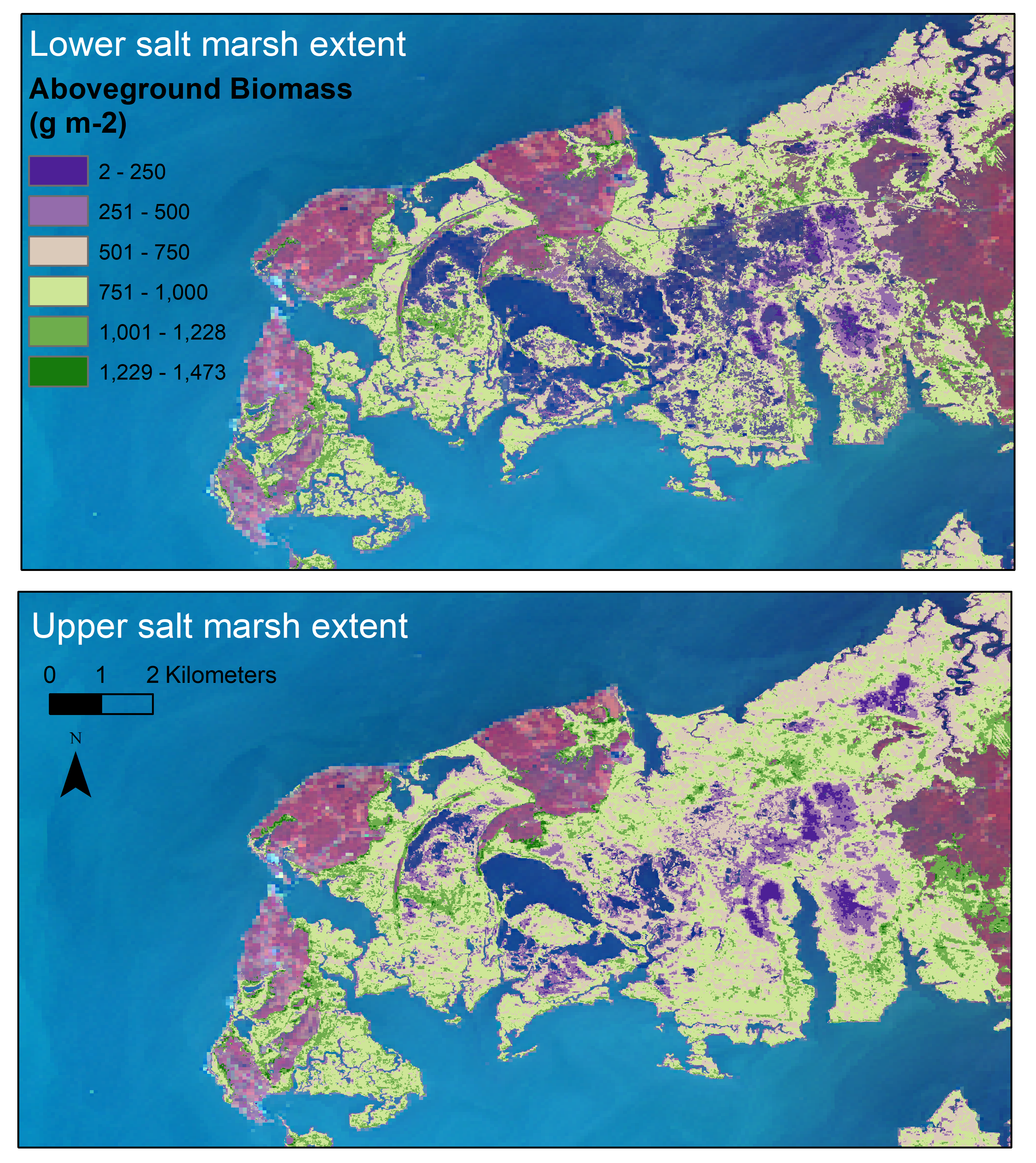
Aboveground Biomass Estimates for Salt Marsh for the Contiguous United States, 2020
National Aeronautics and Space Administration —
This dataset provides estimates of aboveground biomass (AGB) and salt marsh extent in the contiguous United States for 2020 and includes all coastal watersheds across... -
Federal
Archive of Census Related Products (ACRP): 1990 ZIP Equivalency Files
National Aeronautics and Space Administration —
The 1990 Zip Equivalency Files portion of the Archive of Census Related Products (ACRP) contains population and housing data derived from the U.S. Census Bureau's... -
Federal
Collection Series Information File for the 2017 TIGER/Line Shapefile, Current Block Group State-based
U.S. Census Bureau, Department of Commerce —
The TIGER/Line shapefiles and related database files (.dbf) are an extract of selected geographic and cartographic information from the U.S. Census Bureau's Master... -
Federal
Appalachian Basin Play Fairway Analysis: Thermal Quality Analysis in Low-Temperature Geothermal Play Fairway Analysis (GPFA-AB)
Department of Energy —
This collection of files are part of a larger dataset uploaded in support of Low Temperature Geothermal Play Fairway Analysis for the Appalachian Basin (GPFA-AB).... -
Federal
Unpublished Digital Geologic Map of Colonial National Historical Park and Vicinity, Virginia (NPS, GRD, GRI, COLO, COLO digital map) adapted from a Virginia Division of Geology and Mineral Resources Geologic Map by Berquist (2015)
Department of the Interior —
The Unpublished Digital Geologic Map of Colonial National Historical Park and Vicinity, Virginia is composed of GIS data layers and GIS tables in a 10.1 file... -
Federal
Collection TIGER/Line Shapefile, 2019, Series Information for the Address Range-Feature County-based
U.S. Census Bureau, Department of Commerce —
The TIGER/Line shapefiles and related database files (.dbf) are an extract of selected geographic and cartographic information from the U.S. Census Bureau's Master... -
Federal
Appalachian Basin Play Fairway Analysis Thermal Risk Factor and Quality Analyses
Department of Energy —
This submission revises the analysis and products for Thermal Quality Analysis for the northern half of the Appalachian Basin...
24 datasets found for "9 Digit ZIP Code Centroids"