

24 datasets found for "5 Digit ZIP Code Centroids"
-
Federal
Basin and Range Investigation for Developing Geothermal Energy: Exploration Data
Department of Energy —
This data package includes exploration material from the Basin & Range Investigation for Developing Geothermal Energy [in Hidden Systems] project (BRIDGE), which... -
Federal
TIGER/Line Shapefile, 2015, 2010 nation, U.S., 2010 Census 5-Digit ZIP Code Tabulation Area (ZCTA5) National
U.S. Census Bureau, Department of Commerce —
The TIGER/Line shapefiles and related database files (.dbf) are an extract of selected geographic and cartographic information from the U.S. Census Bureau's Master... -
Federal
Estimated Extent of Coastal Flooding due to Storm Surge Data for 79 National Parks
Department of the Interior —
This data release consists of the estimated extent of coastal flooding due to storm surge. Storm surge values were derived from 2 sources; National Weather Service... -
Federal
Wetland Salinity Maps of Select Estuary Sites in the United States, 2020
National Aeronautics and Space Administration —
This dataset provides gridded average annual wetland salinity concentrations in practical salinity units (PSU) at 30-meter resolution within 24 coastal estuary sites... -
Federal
EGS Collab Experiment 1: Microseismic Monitoring
Department of Energy —
The U.S. Department of Energy's Enhanced Geothermal System (EGS) Collab project aims to improve our understanding of hydraulic stimulations in crystalline rock for... -
Federal
TEAMER: Laboratory Evaluation of Dual-Function Oscillating Water Column with Slotted Breakwater - O.H. Hinsdale Wave Research Laboratory
Department of Energy —
This dataset documents a series of controlled laboratory experiments conducted at the O.H. Hinsdale Wave Research Laboratory to evaluate the performance of a dual-... -
Federal
Digital Geologic-GIS Map of the Hagerman Fossil Beds National Monument Area, Idaho (NPS, GRD, GRI, HAFO, HFBA digital map) adapted from a U.S. Geological Survey Miscellaneous Geologic Investigations Map by Malde and Powers (1972)
Department of the Interior —
The Unpublished Digital Geologic-GIS Map of the Hagerman Fossil Beds National Monument Area, Idaho is composed of GIS data layers and GIS tables in a 10.1 file... -
Federal
Unpublished Digital Geologic Map of Bering Land Bridge NP and Vicinity, Alaska (NPS, GRD, GRI, BELA, BELA digital map) adapted from a USGS Open File Report and Scientific Investigations maps by Hudson (1998), Williams (2000) and Till (2010, 2011) and a USGS Unpublished map by Wilson (1999)
Department of the Interior —
The Unpublished Digital Geologic Map of Bering Land Bridge National Preserve and Vicinity, Alaska is composed of GIS data layers and GIS tables in a 10.1 file... -
Federal
Unpublished Digital Bedrock Geologic Map of Aniakchak National Monument and Preserve and Vicinity, Alaska (NPS, GRD, GRI, ANIA, ANIA digital map) adapted from USGS unpublished digital data by Wilson, F.H. (2008) and USGS maps by Pilcher (2000), Wilson (1999) and Detterman (1985)
Department of the Interior —
The Unpublished Digital Bedrock Geologic Map of Aniakchak National Monument and Preserve and Vicinity, Alaska is composed of GIS data layers and GIS tables in a 10.1... -
Federal
Unpublished Digital Geologic Map of Chickasaw National Recreation Area and Vicinity, Oklahoma (NPS, GRD, GRI, CHIC, CHIC digital map)
Department of the Interior —
The Unpublished Digital Geologic Map of Chickasaw National Recreation Area and Vicinity, Oklahoma is composed of GIS data layers and GIS tables in a 10.0 file... -
Federal
Unpublished Digital Geohazards Map of the southern portion of Blue Ridge Parkway, North Carolina (NPS, GRD, GRI, BLRI, BRHZ digital map) adapted from a North Carolina Geological Survey map by Merschat, Carter, and Wooten (2008)
Department of the Interior —
The Unpublished Digital Geohazards Map of the southern portion of Blue Ridge Parkway, North Carolina is composed of GIS data layers and GIS tables in a 10.1 file... -
Federal
LBA-ECO LC-08 Soil, Vegetation, and Land Cover Maps for Brazil and South America
National Aeronautics and Space Administration —
This data set provides (1) soil maps for Brazil that are digital versions of the MAPA DE SOLOS DO BRASIL (EMBRAPA, 1981) classified at three levels of detail,... -
Federal
Unpublished Digital Geologic Map of Colonial National Historical Park and Vicinity, Virginia (NPS, GRD, GRI, COLO, COLO digital map) adapted from a Virginia Division of Geology and Mineral Resources Geologic Map by Berquist (2015)
Department of the Interior —
The Unpublished Digital Geologic Map of Colonial National Historical Park and Vicinity, Virginia is composed of GIS data layers and GIS tables in a 10.1 file... -
Federal
A Dataset from Bio-Loggers Deployed on Adult Bearded Seals (Erignathus barbatus) in Kotzebue Sound, Alaska, USA (2009-2012)
National Oceanic and Atmospheric Administration, Department of Commerce —
Bearded seals (Erignathus barbatus) are one of the most important subsistence resources for the indigenous people of coastal northern and western Alaska, as well as... -
Federal
Unpublished Digital Pre-Hurricane Sandy Geomorphological Map of Fire Island National Seashore and Vicinity, New York (NPS, GRD, GRI, FIIS, FIIS pre-Hurricane Sandy digital map) adapted from a Rutgers University, Institute of Marine and Coastal Sciences map by Psuty, Patel, Freeman, Schmelz, Robertson and Spahn (2014)
Department of the Interior —
**THIS NEWER 2016 DIGITAL MAP REPLACES THE OLDER 2014 VERSION OF THE GRI FIIS Pre-Hurricane Sandy Map. The Unpublished Digital Pre-Hurricane Sandy Geomorphological... -
Federal
Estimated Extent of Coastal Flooding due to Sea Level Change for 118 U.S. National Parks
Department of the Interior —
This data release consists of the estimated extent of inundation due to sea level change for the U.S. national coastal parks of the continental United States, Alaska,... -
Federal
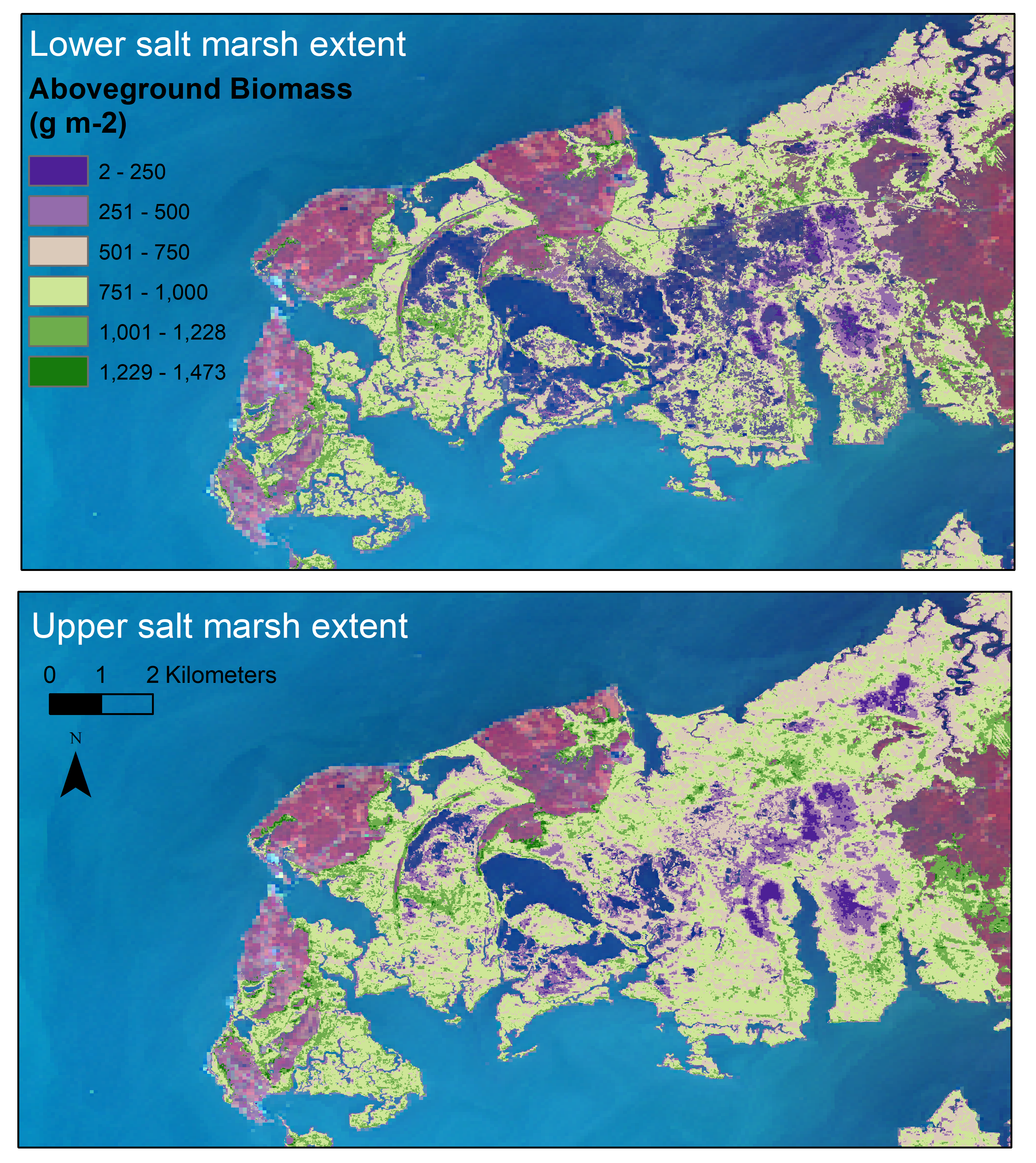
Aboveground Biomass Estimates for Salt Marsh for the Contiguous United States, 2020
National Aeronautics and Space Administration —
This dataset provides estimates of aboveground biomass (AGB) and salt marsh extent in the contiguous United States for 2020 and includes all coastal watersheds across... -
Federal
Unpublished Digital Geologic Map of the southern portion of Blue Ridge Parkway, North Carolina (NPS, GRD, GRI, BLRI, BLRS digital map) adapted from North Carolina Geological Survey maps by Merschat, Carter, and Wooten (2008)
Department of the Interior —
The Unpublished Digital Geologic Map of the southern portion of Blue Ridge Parkway, North Carolina is composed of GIS data layers and GIS tables in a 10.1 file... -
Federal
Unpublished Digital Bedrock Geologic Map of the northern portion of Blue Ridge Parkway, Virginia (NPS, GRD, GRI, BLRI, BLRN digital map) adapted from an unpublished U.S. Geological Survey Map by Carter, Crider, Southworth and Aleinikoff (2016)
Department of the Interior —
The Unpublished Digital Bedrock Geologic Map of the northern portion of Blue Ridge Parkway, Virginia is composed of GIS data layers and GIS tables in a 10.1 file... -
Federal
Unpublished Digital Geomorphic Map of the Shackleford Banks, North Carolina (NPS, GRD, GRI, CALO, SHKB digital map) adapted from a East Carolina University unpublished report and GIS data map by Riggs, Ames and Mallinson (2015)
Department of the Interior —
The Unpublished Digital Geomorphic Map of the Shackleford Banks, North Carolina is composed of GIS data layers and GIS tables in a 10.1 file geodatabase...
24 datasets found for "5 Digit ZIP Code Centroids"