
-
Federal
Wind Magnetic Field Investigation (MFI) Composite Data
National Aeronautics and Space Administration —
Wind MFI composite data in GSE and GSM coordinates. The files contain multiple time resolution data: 3-second, 1-minute, and 1-hour. Final Version 5 data are... -
Federal
NED simple cone search
National Aeronautics and Space Administration —
NED Cone Search service (search for objects Near Position). This service searches NED's master list of extragalactic objects for entries near a given position. -
Federal
GLDAS VIC Land Surface Model L4 monthly 1.0 x 1.0 degree V2.0 (GLDAS_VIC10_M) at GES DISC
National Aeronautics and Space Administration —
NASA Global Land Data Assimilation System Version 2 (GLDAS-2) has three components: GLDAS-2.0, GLDAS-2.1, and GLDAS-2.2. GLDAS-2.0 is forced entirely with the... -
Federal
THIR/Nimbus-7 Level 1 Cloud Data for SBUV/TOMS V001 (THIRN7L1BCLT) at GES DISC
National Aeronautics and Space Administration —
THIRN7L1BCLT is the Nimbus-7 Temperature-Humidity Infrared Radiometer (THIR) Level 1 Cloud Data for SBUV/TOMS (BCLT) product and contains total cloud amounts;... -
Federal
ARC Code TI: SLAB Spatial Audio Renderer
National Aeronautics and Space Administration —
SLAB is a software-based, real-time virtual acoustic environment rendering system being developed as a tool for the study of spatial hearing. SLAB is designed to work... -
Federal
SMEX03 AMSR-E Daily Gridded Soil Moisture and Brightness Temperatures, Alabama, Version 1
National Aeronautics and Space Administration —
Notice to Data Users: The documentation for this data set was provided solely by the Principal Investigator(s) and was not further developed, thoroughly reviewed, or... -
Federal
CI Asteroid Regolith as an In Situ Plant Growth Medium for Space Crop Production
National Aeronautics and Space Administration —
Human expansion into the solar system is currently at the forefront of space research. For our astronauts to survive, they will need to be fed a healthy and... -
Federal
Boknis Pre-SWOT Level-4 Hourly MITgcm LLC4320 Native Grid 2km Oceanographic Dataset Version 1.0
National Aeronautics and Space Administration —
This dataset provides a regional multivariate oceanographic state estimate from a global ocean numerical simulation with a focus on the Baltic Sea region. The global... -
Federal
Global 1-km Gridded Thickness of Soil, Regolith, and Sedimentary Deposit Layers
National Aeronautics and Space Administration —
This data set provides high-resolution estimates of the thickness of the permeable layers above bedrock (soil, regolith, and sedimentary deposits) within a global... -
Federal
Correlated Gene and Protein Expression in heads from Drosophila reared in microgravity
National Aeronautics and Space Administration —
Omics analyses of RNA and protein isolated from heads of microgravity reared adult Drosophila. -
Federal
ALOS PALSAR Low Resolution Radiometric Terrain Corrected Product
National Aeronautics and Space Administration —
ASF's SAR Radiometric Terrain Corrected (RTC) dataset gives terrestrial world-wide coverage; excluding Antarctica, Greenland, Iceland, and Asia north of 60 degrees... -
Federal
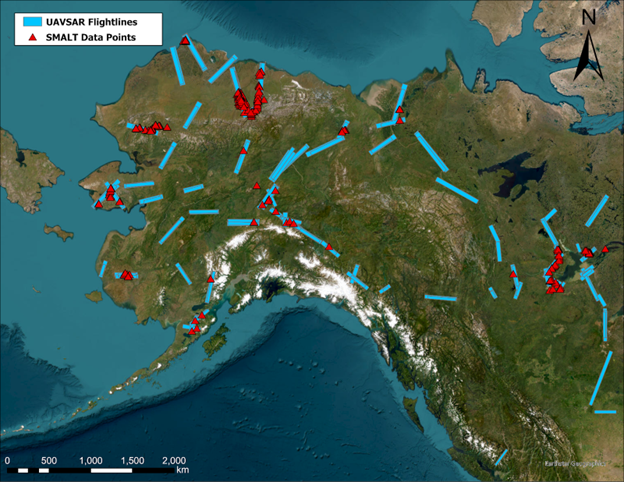
ABoVE: Soil Moisture and Active Layer Thickness in Alaska, USA and Canada, 2005-2022
National Aeronautics and Space Administration —
This dataset provides soil thaw depth and moisture measurements and dielectric properties measured by different research teams at sites in Alaska, U.S., and the... -
Federal
AQUA MODIS High Resolution Level 3 daily aerosol data, 0.1x0.1 degree grid Version 001 (AER_DBDT_D10KM_L3_MODIS_AQUA) at GES DISC
National Aeronautics and Space Administration —
This High-Resolution (0.1 x 0.1 degree) Level 3 daily Aerosol Optical Depth (AOD) product is generated by combining two Moderate Resolution Imaging Spectroradiometer... -
Federal
YSOVAR IRAS 20050+2720 Object Table
National Aeronautics and Space Administration —
The YSOVAR (Young Stellar Object VARiability) Spitzer Space Telescope observing program obtained the first extensive mid-infrared (IRAC 3.6 and 4.5 micron) time... -
Federal
VIIRS/JPSS1 BRDF/Albedo Parameter 3 Band M1 Daily L3 Global 30 ArcSec CMG V002
National Aeronautics and Space Administration —
The NOAA-20 Visible Infrared Imaging Radiometer Suite (VIIRS) Bidirectional Reflectance Distribution Function (BRDF) and Albedo Model Parameter 3 Band M1 product... -
Federal
TROPICS03 L1A Orbital Geolocated Native-Resolution Antenna Temperatures V1.0
National Aeronautics and Space Administration —
The "Time-Resolved Observations of Precipitation structure and storm Intensity with a Constellation of Smallsats" (TROPICS) mission has a goal of providing nearly... -
Federal
SMEX03 SSM/I Brightness Temperature Data, Georgia, Version 1
National Aeronautics and Space Administration —
This data set provides brightness temperature data acquired during the Soil Moisture Experiment 2003 (SMEX03) by the Special Sensor Microwave/Imager (SSM/I). -
Federal
BARREL 2B Tri-axial Fluxgate Magnetometer (MAGN) Magnetic Field Data, no Gain Correction, not Despun, Level 2, 0.25 s Data
National Aeronautics and Space Administration —
Three axis DC magnetometer data with nominal conversions applied. Data are neither gain corrected nor despun.The BARREL Mission was a multiple-balloon investigation... -
Federal
BARREL 2N X-ray Spectrometer (SSPC) Bremsstrahlung X-ray Spectrum Slow Time Resolution, Level 2, 32 s Data
National Aeronautics and Space Administration —
SSPC: 256 channels of slow time resolution, 32 s, Bremsstrahlung X-ray spectra detected with a NaI Scintillator. The nominal energy range covered by the 256 channels... -
Federal
Herschel SPIRE Point Source Catalog: 350 microns
National Aeronautics and Space Administration —
The Herschel-SPIRE instrument mapped about 9% of the sky in Submillimeter broad-band filters centered at 250, 350, and 500 microns (1199, 857, 600 GHz) with spatial...

Official websites use .gov
A
.gov website belongs to an official government
organization in the United States.
Secure .gov websites use HTTPS
A
lock (
) or https:// means you’ve safely connected to
the .gov website. Share sensitive information only on official,
secure websites.