
-
Federal
SWOT Level 2 River Single-Pass Vector Data Product, Version D
National Aeronautics and Space Administration —
The SWOT Level 2 River Single-Pass Vector Data Product (SWOT_L2_HR_RiverSP_D) provides hydrologic measurements for predefined river reaches and nodes, derived from... -
Federal
2020-2023 CCAP Version 2 Impervious Cover
National Oceanic and Atmospheric Administration, Department of Commerce —
The NOAA Coastal Change Analysis Program (C-CAP) produces national standardized land cover and change products for the coastal regions of the U.S. C-CAP products... -
Federal
Pre-LBA ISLSCP Initiative I Data
National Aeronautics and Space Administration —
This data set contains hydrology, soils, radiation, cloud, and vegetation data from the International Satellite Land Surface Climatology Project (ISLSCP) Initiative... -
Federal
Pre-Delta-X: Total Suspended Solids of Surface Water across MRD, LA, USA, 2015-2016
National Aeronautics and Space Administration —
This dataset contains the total suspended solids (TSS) concentration of in situ water samples collected at selected sites across the Atchafalaya and Terrebonne Basins... -
Federal
2020-2023 CCAP Version 2 Canopy Cover
National Oceanic and Atmospheric Administration, Department of Commerce —
The NOAA Coastal Change Analysis Program (C-CAP) produces national standardized land cover and change products for the coastal regions of the U.S. C-CAP products... -
Federal
SWOT Level 2 Water Mask Raster Image 100m Data Product, Version D
National Aeronautics and Space Administration —
The SWOT Level 2 KaRIn High Rate Raster Product (SWOT_L2_HR_Raster_D) provides rasterized estimates of water surface elevation, inundation extent, and radar... -
Federal
BOREAS TGB-04 NSA-BVP Tower Flux and Meteorological Data
National Aeronautics and Space Administration —
The BOREAS TGB-04 team measured the exchange of heat, water, and CO2 between a boreal forest beaver pond and the atmosphere in the NSA for the ice-free period of... -
Federal
LBA-ECO CD-06 Carbon Cycling in Rivers in Amazonas and Acre, Brazil: 2005-2006
National Aeronautics and Space Administration —
This data set provides measured and calculated variables describing the carbon pools in river waters, CO2 respired from the water and total amount of CO2 evaded,... -
Federal
Delta-X: Bed and Suspended Sediment Grain Size, MRD, LA, USA, 2019-2021, V3
National Aeronautics and Space Administration —
This dataset includes sediment concentration and grain size distribution measurements from suspended and bed sediment samples collected in the Atchafalaya River and... -
Federal
ABoVE: Wetland Vegetation Classification for Peace-Athabasca Delta, Canada, 2019
National Aeronautics and Space Administration —
This dataset contains land cover classification focused on water and wetland vegetation communities over the Peace-Athabasca Delta, Canada. Four classification maps... -
Federal
SAFARI 2000 Wetlands Data Set, 1-Deg (Matthews and Fung)
National Aeronautics and Space Administration —
This database, compiled by Matthews and Fung (1987), provides information on the distribution and environmental characteristics of natural wetlands. The database was... -
Federal
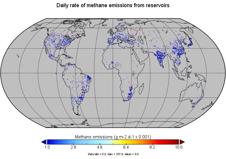
Global-Gridded Daily Methane Emissions from Inland Dam-Reservoir Systems
National Aeronautics and Space Administration —
This dataset includes global maps of methane (CH4) emissions from inland dam-reservoir systems at 0.25-degree spatial resolution. Daily emission rates (as grams of... -
Federal
LBA Regional Hydrographic Data, 1-Degree, Release 2.2 (Cogley)
National Aeronautics and Space Administration —
This subset of the Global Hydrographic data set (GGHYDRO) Release 2.2 for the study area of the Large Scale Biosphere-Atmosphere Experiment in Amazonia (LBA) in South... -
Federal
LBA Regional Freshwater Wetlands, 1-Degree (Stillwell-Soller et al.)
National Aeronautics and Space Administration —
This data set consists of a subset of a 1-degree gridded global freshwater wetlands database (Stillwell-Soller et al. 1995). This subset was created for the study... -
Federal
2020-2023 CCAP Version 2 Water Cover
National Oceanic and Atmospheric Administration, Department of Commerce —
The NOAA Coastal Change Analysis Program (C-CAP) produces national standardized land cover and change products for the coastal regions of the U.S. C-CAP products... -
Federal
Lund-Potsdam-Jena Wetland Hydrology and Methane DGV Model (LPJ-WHyMe v1.3.1)
National Aeronautics and Space Administration —
This model product provides the Fortran 77 source code for the Lund-Potsdam-Jena (LPJ) Wetland Hydrology and Methane Dynamic Global Vegetation Model (LPJ-WHyMe... -
Federal
SWOT Level 2 Water Mask Pixel Cloud Auxiliary Data Product, Version C
National Aeronautics and Space Administration —
Auxiliary information for pixel cloud product indicating to which water bodies the pixels are assigned in river and lake products. Also includes height-constrained... -
Federal
Collection TIGER/Line Shapefile, 2012, Series Information File for the Linear Hydrography County-based Shapefiles
U.S. Census Bureau, Department of Commerce —
The TIGER/Line shapefiles and related database files (.dbf) are an extract of selected geographic and cartographic information from the U.S. Census Bureau's Master... -
Federal
Western Alaska ESI: HYDRO (Land Mass Polygons)
National Oceanic and Atmospheric Administration, Department of Commerce —
This data set contains vector polygons representing coastal hydrography that defines the primary land masses used in the creation of the Environmental Sensitivity... -
Federal
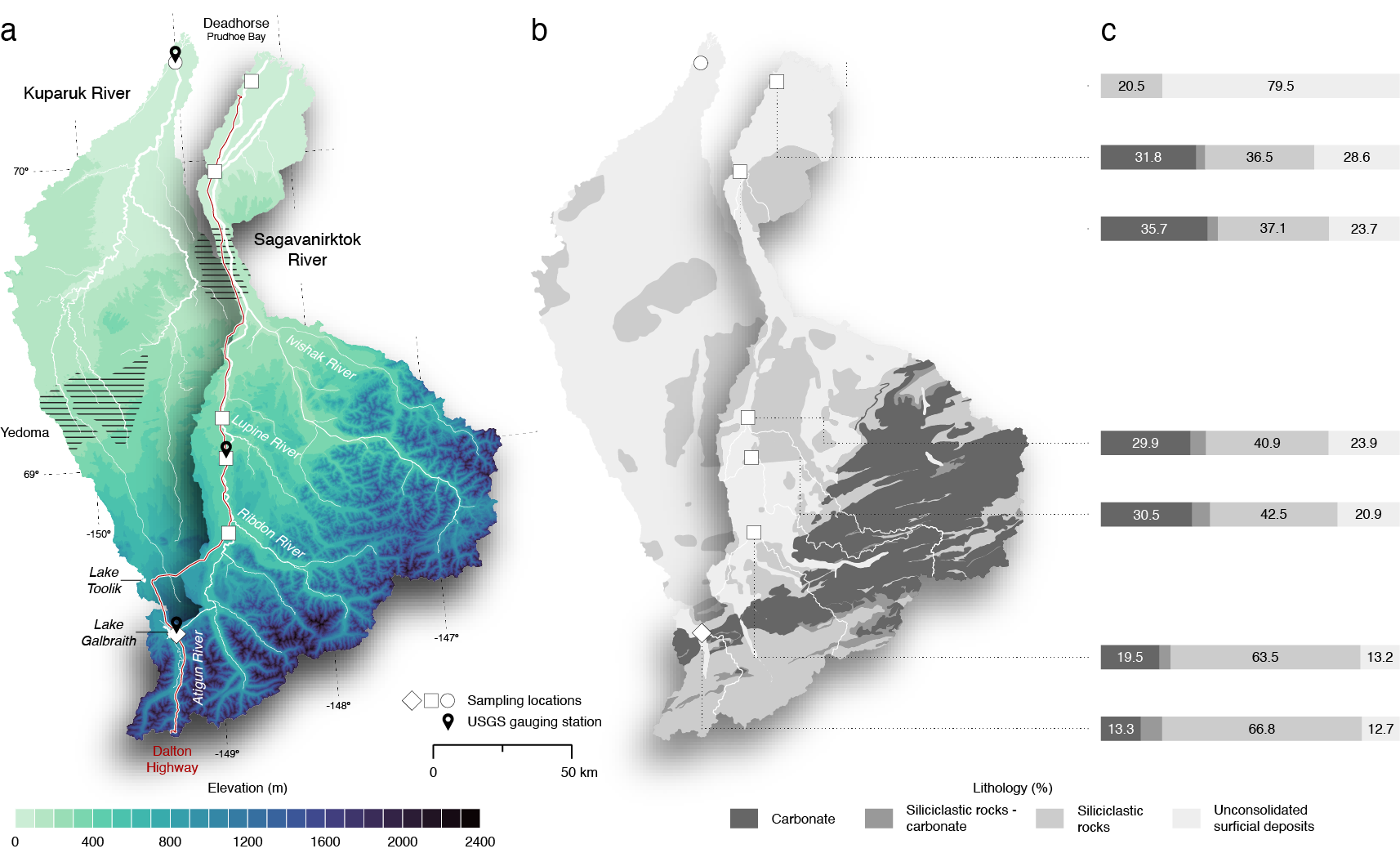
ABoVE: Seasonal Dissolved Gases and Isotopes in Arctic Alaska Rivers
National Aeronautics and Space Administration —
This dataset provides dissolved carbon dioxide (CO2) and methane (CH4) concentrations alongside their stable and radiocarbon isotopic compositions within the Arctic...

Official websites use .gov
A
.gov website belongs to an official government
organization in the United States.
Secure .gov websites use HTTPS
A
lock (
) or https:// means you’ve safely connected to
the .gov website. Share sensitive information only on official,
secure websites.