
-
Federal
Monitoring Trends in Burn Severity Burned Area Boundaries (Feature Layer)
Department of Agriculture —
The Monitoring Trends in Burn Severity (MTBS) Program assesses the frequency, extent, and magnitude (size and severity) of all large wildland fires (including... -
Federal
Landsat 7 ETM/1G satellite imagery - Hawaiian Islands cloud-free mosaics
National Oceanic and Atmospheric Administration, Department of Commerce —
Cloud-free Landsat satellite imagery mosaics of the islands of the main 8 Hawaiian Islands (Hawaii, Maui, Kahoolawe, Lanai, Molokai, Oahu, Kauai and Niihau). Landsat... -
Federal
Monitoring Trends in Burn Severity Fire Occurrence Locations (Feature Layer) NGDA
Department of Agriculture —
The Monitoring Trends in Burn Severity MTBS project assesses the frequency, extent, and magnitude (size and severity) of all large wildland fires (includes wildfire,... -
Federal
Satellite Landsat TM Extr. Data (FIFE)
National Aeronautics and Space Administration —
The Thematic Mapper sensor system was used to collect the original data between February 1987 and October 1989 from which this data set was produced. Landsat TM... -
Federal
SAFARI 2000 MODIS 500-m Burned Area Products, Southern Africa, Dry Season 2000
National Aeronautics and Space Administration —
The SAFARI 2000 project was selected as the first regional test for a prototype regional 500 m MODIS burned area product. The MODIS burned area product maps the 500 m... -
Federal
BOREAS AFM-12 1-km AVHRR Seasonal Land Cover Classification
National Aeronautics and Space Administration —
This regional land cover classification is based on the use of multitemporal 1-km Advanced Very High Resolution Radiometer (AVHRR) National Oceanic and Atmospheric... -
Federal
LBA-ECO ND-01 Land Cover Classification, Rondonia, Brazil: 1975-2000
National Aeronautics and Space Administration —
This data set provides a time series of land cover classifications for Ariquemes, Ji-Parana, and Luiza, research sites in Rondonia, Brazil. The land cover... -
Federal
Land Cover and Land Use Classification for the State of New Hampshire, 1996-2001
National Aeronautics and Space Administration —
The New Hampshire Geographically Referenced Analysis and Information Transfer System (GRANIT) land cover data set provides a land cover and land use product at 30-m... -
Federal
SAFARI 2000 ALI/ETM+ Tandem Image Pair for Skukuza, South Africa, May 2001
National Aeronautics and Space Administration —
A tandem pair of Advanced Land Imager (ALI) and Landsat Enhanced Thematic Mapper Plus (ETM+) scenes covering the same part of Kruger National Park (KNP), South Africa... -
Federal
Imagery data for the Vegetation Mapping Inventory Project of Lassen Volcanic National Park
Department of the Interior —
This reference contains the imagery data used in the completion of the baseline vegetation inventory project for the NPS park unit. Orthophotos, raw imagery, and... -
Federal
LBA-ECO ND-01 Landsat 28.5-m Land Cover Time Series, Rondonia, Brazil: 1984-2010
National Aeronautics and Space Administration —
This data set provides a 27-year land cover time series of 28.5-m resolution products derived from Landsat images for 80% of Rondonia, Brazil, for the period 1984 to... -
Federal
Imagery data for the Vegetation Mapping Inventory Project of Bandelier National Monument
Department of the Interior —
This reference contains the imagery data used in the completion of the baseline vegetation inventory project for the NPS park unit. Orthophotos, raw imagery, and... -
Federal
LBA-ECO ND-01 Primary Forests Land Cover Transition Maps, Rondonia, Brazil: 1975-1999
National Aeronautics and Space Administration —
This data set provides classified land cover transition images (maps) derived from Landsat Thematic Mapper (TM) and Multispectral Scanner (MSS) imagery for Ariquemes,... -
Federal
Decadal Land Use and Land Cover Classifications across India, 1985, 1995, 2005
National Aeronautics and Space Administration —
This data set provides land use and land cover (LULC) classification products at 100-m resolution for India at decadal intervals for 1985, 1995 and 2005. The data... -
Federal
LBA-ECO ND-01 Fractional Land Cover Images, Rondonia, Brazil: 1984-2000
National Aeronautics and Space Administration —
This data set provides fractional land cover type images for shade, green vegetation (GV), non-photosynthetic vegetation (NPV), and soil for the regions of JiParana,... -
Federal
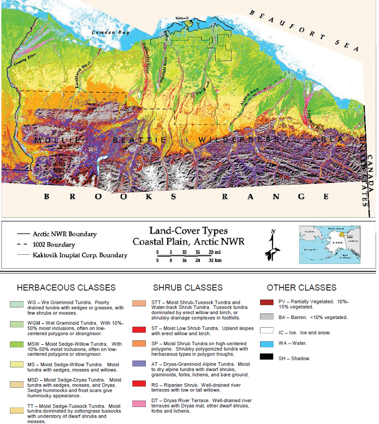
Land Cover and Vegetation Map, Arctic National Wildlife Refuge
National Aeronautics and Space Administration —
This data set provides a landcover map with 16 landcover classes for the northern coastal plain of the the Arctic National Wildlife Refuge (ANWR) on the North Slope... -
Federal
LBA-ECO ND-01 Streamwater and Watershed Characteristics, Rondonia, Brazil: 1998-1999
National Aeronautics and Space Administration —
This data set provides the results of (1) synoptic streamwater sampling and analyses from numerous sites across Rondonia and (2) corresponding watershed... -
Federal
Global Food Security-support Analysis Data (GFSAD) Cropland Extent 2015 Europe, Central Asia, Russia, Middle East product 30 m V001
National Aeronautics and Space Administration —
The NASA Making Earth System Data Records for Use in Research Environments (MEaSUREs) Global Food Security-support Analysis Data (GFSAD) data product provides... -
Federal
Global Food Security-support Analysis Data (GFSAD) Cropland Extent 2015 South America product 30 m V001
National Aeronautics and Space Administration —
The NASA Making Earth System Data Records for Use in Research Environments (MEaSUREs) Global Food Security-support Analysis Data (GFSAD) data product provides... -
Federal
LBA-ECO ND-01 Georegistered Landsat Imagery for Rondonia, Brazil: 1975-2000
National Aeronautics and Space Administration —
This data set provides a time series of Landsat Multispectral Scanner (MSS), Thematic Mapper (TM), and Enhanced Thematic Mapper Plus (ETM+) scenes for five (Path/Row)...

Official websites use .gov
A
.gov website belongs to an official government
organization in the United States.
Secure .gov websites use HTTPS
A
lock (
) or https:// means you’ve safely connected to
the .gov website. Share sensitive information only on official,
secure websites.