
-
Federal
Global Vegetation Greenness (NDVI) from AVHRR GIMMS-3G+, 1981-2022
National Aeronautics and Space Administration —
This dataset holds the Global Inventory Modeling and Mapping Studies-3rd Generation V1.2 (GIMMS-3G+) data for the Normalized Difference Vegetation Index (NDVI). NDVI... -
Federal
Aboveground Biomass, Landcover, and Degradation, Kalimantan Forests, Indonesia, 2014
National Aeronautics and Space Administration —
This dataset provides estimates of aboveground biomass, percent canopy cover, mean canopy height, landcover, and forest degradation index products for forests in... -
Federal
Leaf Area Index Maps at 30-m Resolution, VALERI Site, Larose, Canada
National Aeronautics and Space Administration —
This data set provide local LAI maps for the Larose (Ontario) site in Canada. These derived maps may also be useful for validating other LAI maps over this same site... -
Federal
NACP Peatland Landcover Type and Wildfire Burn Severity Maps, Alberta, Canada
National Aeronautics and Space Administration —
This data set provides landcover maps of (1) peatland type (bog, fen, marsh, swamp) with levels of biomass (open, forested) and (2) Burn Severity Index (BSI) (Dyrness... -
Federal
Ecosystem Functional Type Distribution Map for the Conterminous USA, 2001-2014
National Aeronautics and Space Administration —
This dataset provides maps of the distribution of ecosystem functional types (EFTs) and the interannual variability of EFTs at 0.05 degree resolution across the... -
Federal
ISLSCP II University of Maryland Global Land Cover Classifications, 1992-1993
National Aeronautics and Space Administration —
The objective of the International Satellite Land Surface Climatology Project (ISLSCP II) study that produced this data set, ISLSCP II University of Maryland Global... -
Federal
Multispectral Imagery, NDVI, and Terrain Models, Big Trail Lake, Fairbanks, AK, 2019
National Aeronautics and Space Administration —
This dataset provides multispectral reflectance imagery (green at 550 nm, red at 660 nm, red edge at 735 nm, and near-infrared at 790 nm), normalized difference... -
Federal
ABoVE: Wetland Type, Slave River and Peace-Athabasca Deltas, Canada, 2007 and 2017
National Aeronautics and Space Administration —
This dataset provides ecosystem-types for the Slave River Delta (SRD) and Peace-Athabasca Delta (PAD), Canada, for the time periods circa 2007 and circa 2017. The... -
Federal
BOREAS AFM-12 1-km AVHRR Seasonal Land Cover Classification
National Aeronautics and Space Administration —
This regional land cover classification is based on the use of multitemporal 1-km Advanced Very High Resolution Radiometer (AVHRR) National Oceanic and Atmospheric... -
Federal
Arctic Alaska Vegetation, Geobotanical, Physiographic Maps, 1993-2005
National Aeronautics and Space Administration —
This data set provides the spatial distributions of vegetation types, geobotanical characteristics, and physiographic features for the Arctic tundra region of Alaska... -
Federal
Maps of Vegetation, NDVI, Snow and Thaw Depths: North Slope, Alaska and NWT, Canada
National Aeronautics and Space Administration —
This dataset includes vegetation cover maps, Normalized Difference Vegetation Index (NDVI) maps, snow depth and thaw depth data that were obtained as part of a... -
Federal
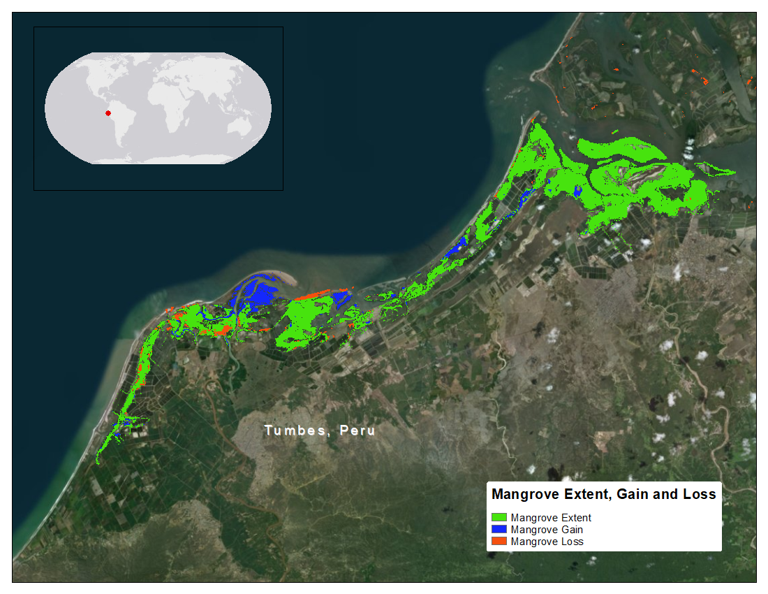
CMS: Mangrove Forest Cover Extent and Change across Major River Deltas, 2000-2016
National Aeronautics and Space Administration —
This dataset provides estimates of mangrove extent for 2016, and mangrove change (gain or loss) from 2000 to 2016, in major river delta regions of eight countries:... -
Federal
MODIS-derived Biophysical Parameters for 5-km Land Cover, North America, 2000-2012
National Aeronautics and Space Administration —
This data set provides MODIS-derived surface biophysical climatologies of bidirectional distribution function (BRDF), BDRF/albedo, land surface temperature (LST),... -
Federal
SAFARI 2000 TOMS Aerosol Index Data, Southern Africa, Dry Season 2000
National Aeronautics and Space Administration —
Daily Aerosol Index (AI) data from Earth Probe (EP) Total Ozone Mapping Spectrometer (TOMS) for the period of August 12-September 25, 2000 were processed and provided... -
Federal
Resilience of Coastal Wetlands to Sea Level Rise, CONUS, 1996-2100
National Aeronautics and Space Administration —
This dataset provides information about the resilience of tidal wetlands to sea-level rise under three scenarios of global change. With rising seas, regularly... -
Federal
SAFARI 2000 NBI Vegetation Map of the Savannas of Southern Africa
National Aeronautics and Space Administration —
The National Botanical Institute (NBI) has mapped woody plant species distribution to provide estimates of individual species contribution to peak leaf area index for... -
Federal
Phenoregions For Monitoring Vegetation Responses to Climate Change
National Aeronautics and Space Administration —
The overall purpose in this research was to identify the regions of the world best suited for long-term monitoring of biospheric responses to climate change, i.e.... -
Federal
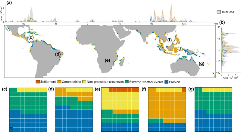
Global Mangrove Loss Extent, Land Cover Change, and Loss Drivers, 2000-2016
National Aeronautics and Space Administration —
This dataset provides estimates of the extent of mangrove loss, land cover change, and its anthropogenic or climatic drivers in three time periods: 2000-2005,... -
Federal
BOREAS Follow-On DSP-10 Regridded FPAR and LAI Maps for 1994
National Aeronautics and Space Administration —
Existing BOREAS gridded data sets were processed into projections and scales required by the Follow-on modeling teams. Existing TM and AVHRR based landcover maps,...

Official websites use .gov
A
.gov website belongs to an official government
organization in the United States.
Secure .gov websites use HTTPS
A
lock (
) or https:// means you’ve safely connected to
the .gov website. Share sensitive information only on official,
secure websites.