
-
Federal
GPM SSMI on F08 (GPROF) Climate-based Radiometer Precipitation Profiling L3 1 day 0.25 degree x 0.25 degree V07 (GPM_3GPROFF08SSMI_DAY_CLIM) at GES DISC
National Aeronautics and Space Administration —
Version 7 is the current version of the data set. Older versions will no longer be available and have been superseded by the current version. The "CLIM" products... -
Federal
OMPS-NPP L2 LP Ozone (O3) Vertical Profile swath daily 3slit V2.5 (OMPS_NPP_LP_L2_O3_DAILY) at GES DISC
National Aeronautics and Space Administration —
The OMPS-NPP L2 LP Ozone (O3) Vertical Profile swath daily 3slit collection contains ozone measured by the Ozone Mapping and Profiling Suite (OMPS) Limb-Profiler (LP)... -
Federal
Sounder SIPS: AQUA AIRS IR + MW Level 3 CLIMCAPS: Specific Quality Control Gridded Monthly V2 (SNDRAQIML3SMCCP) at GES DISC
National Aeronautics and Space Administration —
WARNING: To users of the derived product “co_mmr_midtrop” (carbon monoxide mass mixing ratio to dry air [kg/kg] at ~500 hPa). This variable has a significant bias due... -
Federal
GPM MHS on NOAA19 (GPROF) Radiometer Precipitation Profiling L3 1 month 0.25 degree x 0.25 degree V07 (GPM_3GPROFNOAA19MHS) at GES DISC
National Aeronautics and Space Administration —
Version 07 is the current version of the data set. Older versions will no longer be available and have been superseded by Version 07. 3GPROF products provide global... -
Federal
GVHRR/ATS-6 Black and White Visible Images on Film V001 (GVHRRATS6IMVIS) at GES DISC
National Aeronautics and Space Administration —
GVHRRATS6IMVIS is the Geosynchronous Very High Resolution Radiometer (GVHRR) Black and White Visible Images on Film data product from the sixth Applications... -
Federal
NLDAS Mosaic Land Surface Model L4 Monthly 0.125 x 0.125 degree V2.0 (NLDAS_MOS0125_M) at GES DISC
National Aeronautics and Space Administration —
This data set contains thirty-seven fields simulated from the Mosaic land-surface model (LSM) for Phase 2 of the North American Land Data Assimilation System... -
Federal
CAR Discover AQ BRDF Measurements V2 (CAR_DISCOVERAQ_BRDF_2)
National Aeronautics and Space Administration —
DISCOVER-AQ, a NASA Earth Venture program funded mission, stands for Deriving Information on Surface Conditions from Column and Vertically Resolved Observations... -
Federal
TIROS-4 Medium-Resolution Scanning Radiometer Level 1 Final Meteorological Radiation Data V001 (TIROS4L1FMRT) at GES DISC
National Aeronautics and Space Administration —
TIROS-4 Medium-Resolution Scanning Radiometer Level 1 Final Meteorological Radiation Data (FMRT) product contains radiances expressed in five infrared/visible... -
Federal
GPM SSMIS on F17 (GPROF) Radiometer Precipitation Profiling L3 1 month 0.25 degree x 0.25 degree V07 (GPM_3GPROFF17SSMIS) at GES DISC
National Aeronautics and Space Administration —
Version 07 is the current version of the data set. Older versions will no longer be available and have been superseded by Version 07.3GPROF products provide global... -
Federal
NLDAS VIC Land Surface Model L4 Monthly Climatology 0.125 x 0.125 degree V2.0 (NLDAS_VIC0125_MC) at GES DISC
National Aeronautics and Space Administration —
This data set contains a series of land surface parameters simulated from the VIC land-surface model (LSM) for Phase 2 of the North American Land Data Assimilation... -
Federal
MERRA-2 inst1_2d_asm_Nx: 2d,1-Hourly,Instantaneous,Single-Level,Assimilation,Single-Level Diagnostics 0.625 x 0.5 degree V5.12.4 (M2I1NXASM) at GES DISC
National Aeronautics and Space Administration —
M2I1NXASM (or inst1_2d_asm_Nx) is an instantaneous 2-dimensional hourly data collection in Modern-Era Retrospective analysis for Research and Applications version 2... -
Federal
GPM MHS on METOP-C (GPROF) Radiometer Precipitation Profiling L3 1 day 0.25 degree x 0.25 degree V07 (GPM_3GPROFMETOPCMHS_DAY) at GES DISC
National Aeronautics and Space Administration —
Version 07 is the current version of the data set. 3GPROF products provide global gridded monthly/daily precipitation averages from multiple satellites that can be... -
Federal
SBUV2/NOAA-19 Ozone (O3) Nadir Profile and Total Column 1 Day L2 V1 (SBUV2N19L2) at GES DISC
National Aeronautics and Space Administration —
The Solar Backscattered Ultraviolet (SBUV) from NOAA-19 Level-2 daily product (SBUV2N19L2) contains ozone nadir profile and total column data from retrievals... -
Federal
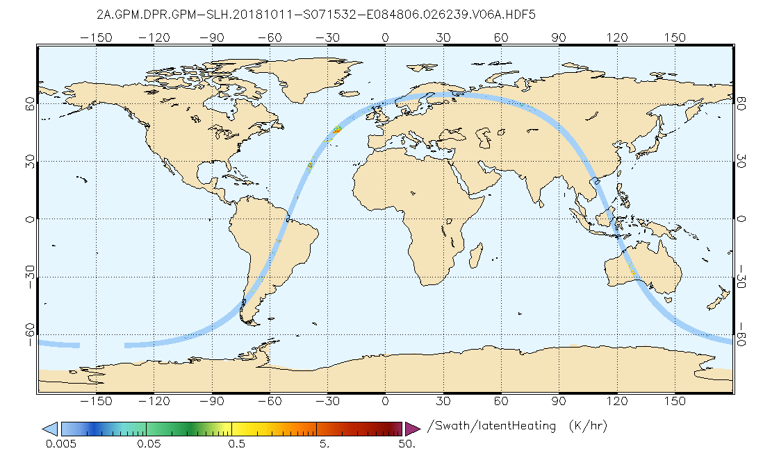
GPM DPR Spectral Latent Heating Profiles L2 1.5 hours 5 km V07 (GPM_2HSLH) at GES DISC
National Aeronautics and Space Administration —
Version 6B of these data were introduced in July, 2020. Please, see documentation tab for release notes. Latent heating variables are retrieved utilizing two separate... -
Federal
HIRS/Nimbus-6 Images of Brightness Temperature on 70 mm Film V001 (HIRSN6IM) at GES DISC
National Aeronautics and Space Administration —
The HIRSN6IM data product consists of images of brightness temperatures on 70 mm film strips from the Nimbus-6 High Resolution Infrared Radiation Sounder. Each... -
Federal
VISSR/SMS-1 Visible Imagery on 70mm Film V001 (VISSRSMS1IMVIS) at GES DISC
National Aeronautics and Space Administration —
VISSRSMS1IMVIS is the Visible Infrared Spin-Scan Radiometer (VISSR) Visible Imagery on 70mm Film data product from the first Synchronous Meteorological Satellite... -
Federal
MLS/Aura Level 2 Carbon Monoxide (CO) Mixing Ratio V005 (ML2CO) at GES DISC
National Aeronautics and Space Administration —
ML2CO is the EOS Aura Microwave Limb Sounder (MLS) standard product for carbon monoxide derived from radiances measured by the 640 GHz radiometer. The data version is... -
Federal
MLS/Aura Level 3 Daily Binned Temperature on Zonal and Similar Grids V005 (ML3DZT) at GES DISC
National Aeronautics and Space Administration —
ML3DZT is the EOS Aura Microwave Limb Sounder (MLS) daily binned on zonal and assorted vertical grids product for temperature derived from radiances measured by the... -
Federal
AIRS/Aqua L2 Standard Physical Retrieval (AIRS+AMSU) V006 (AIRX2RET) at GES DISC
National Aeronautics and Space Administration —
The Atmospheric Infrared Sounder (AIRS) is a grating spectrometer (R = 1200) aboard the second Earth Observing System (EOS) polar-orbiting platform, EOS Aqua. In... -
Federal
TROPESS CrIS-JPSS1 L2 Ammonia for Forward Stream, Standard Product V1 (TRPSDL2NH3CRS1FS) at GES DISC
National Aeronautics and Space Administration —
The TROPESS CrIS-JPSS1 L2 Ammonia for Forward Stream, Standard Product contains the vertical distribution of the retrieved atmospheric state of ammonia (NH3), formal...

Official websites use .gov
A
.gov website belongs to an official government
organization in the United States.
Secure .gov websites use HTTPS
A
lock (
) or https:// means you’ve safely connected to
the .gov website. Share sensitive information only on official,
secure websites.