
-
Federal
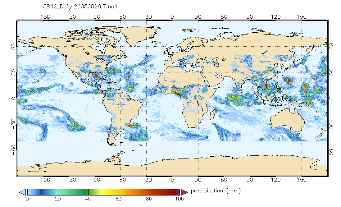
TRMM (TMPA) Precipitation L3 1 day 0.25 degree x 0.25 degree V7 (TRMM_3B42_Daily) at GES DISC recent views
National Aeronautics and Space Administration —
TMPA (3B42_Daily) dataset have been discontinued as of Dec. 31, 2019, and users are strongly encouraged to shift to the successor IMERG dataset (doi:... -
Federal
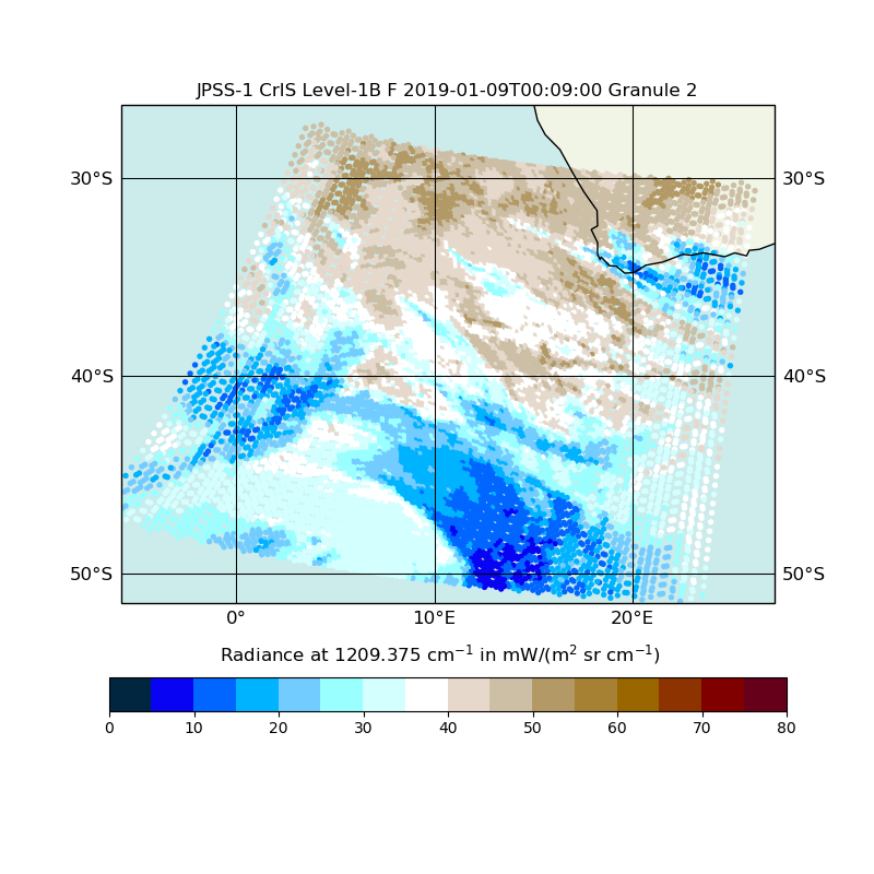
JPSS-1 CrIS Level 1B Full Spectral Resolution V2 (SNDRJ1CrISL1B) at GES DISC recent views
National Aeronautics and Space Administration —
The Cross-track Infrared Sounder (CrIS) Level 1B Full Spectral Resolution (FSR) data files contain radiance measurements along with ancillary spacecraft, instrument,... -
Federal
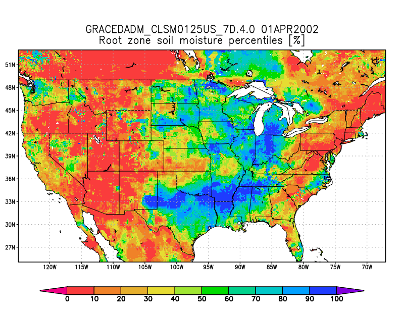
Groundwater and Soil Moisture Conditions from GRACE and GRACE-FO Data Assimilation L4 7-days 0.125 x 0.125 degree U.S. V4.0 (GRACEDADM_CLSM0125US_7D) at GES DISC recent views
National Aeronautics and Space Administration —
Scientists at NASA Goddard Space Flight Center generate groundwater and soil moisture drought indicators each week. They are based on terrestrial water storage... -
Federal
GLDAS Noah Land Surface Model L4 3 hourly 0.25 x 0.25 degree V2.0 (GLDAS_NOAH025_3H) at GES DISC recent views
National Aeronautics and Space Administration —
NASA Global Land Data Assimilation System Version 2 (GLDAS-2) has three components: GLDAS-2.0, GLDAS-2.1, and GLDAS-2.2. GLDAS-2.0 is forced entirely with the... -
Federal
MLS/Aura Level 3 Daily Binned Cloud Ice (IWC) on Assorted Grids V005 (ML3DBIWC) at GES DISC recent views
National Aeronautics and Space Administration —
ML3DBIWC is the EOS Aura Microwave Limb Sounder (MLS) daily binned on various vertical grids product for cloud ice water content (IWC) derived from radiances measured... -
Federal
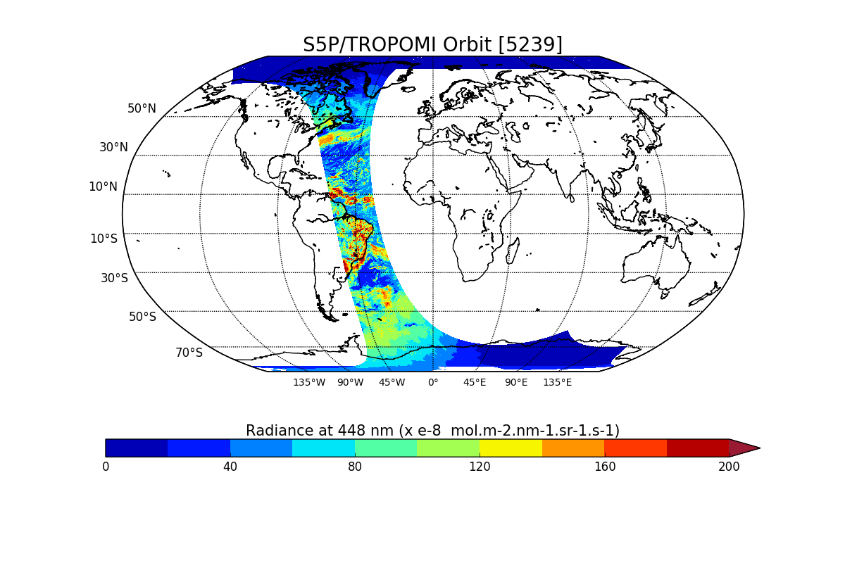
Sentinel-5P TROPOMI Radiance product band 4 (UVIS detector) L1B V1 (S5P_L1B_RA_BD4) at GES DISC recent views
National Aeronautics and Space Administration —
Starting from August 6th in 2019, Sentinel-5P TROPOMI along-track high spatial resolution (~5.5km at nadir) has been implemented. For data after August 6th of 2019,... -
Federal
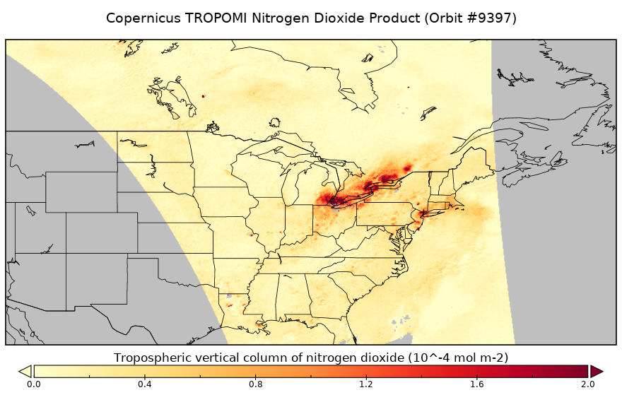
Sentinel-5P TROPOMI Tropospheric NO2 1-Orbit L2 5.5km x 3.5km V1 (S5P_L2__NO2____HiR) at GES DISC recent views
National Aeronautics and Space Administration —
Starting from August 6th in 2019, Sentinel-5P TROPOMI along-track high spatial resolution (~5.5km at nadir) has been implemented. For data before August 6th of 2019,... -
Federal
Suomi NPP CrIS Level 1B Normal Spectral Resolution V3 (SNPPCrISL1BNSR) at GES DISC recent views
National Aeronautics and Space Administration —
The Cross-track Infrared Sounder (CrIS) Level 1B Normal Spectral Resolution (NSR) data files contain radiance measurements along with ancillary spacecraft,... -
Federal
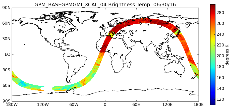
GPM GMI XCAL Common Calibrated Brightness Temperatures L1BASE 1.5 hours 13 km V07 (GPM_BASEGPMGMI_XCAL) at GES DISC recent views
National Aeronautics and Space Administration —
Version 07 is the current version of the data set. Older versions are no longer available and have been superseded by the current version. Consistent rainfall... -
Federal
GPM SSMIS on F17 (GPROF) Climate-based Radiometer Precipitation Profiling L3 1 day 0.25 degree x 0.25 degree V07 (GPM_3GPROFF17SSMIS_DAY_CLIM) at GES DISC recent views
National Aeronautics and Space Administration —
Version 07 is the current version of the data set. Older versions will no longer be available and have been superseded by Version 07. The "CLIM" products differ from... -
Federal
GLDAS Noah Land Surface Model L4 monthly 1.0 x 1.0 degree V2.0 (GLDAS_NOAH10_M) at GES DISC recent views
National Aeronautics and Space Administration —
NASA Global Land Data Assimilation System Version 2 (GLDAS-2) has three components: GLDAS-2.0, GLDAS-2.1, and GLDAS-2.2. GLDAS-2.0 is forced entirely with the... -
Federal
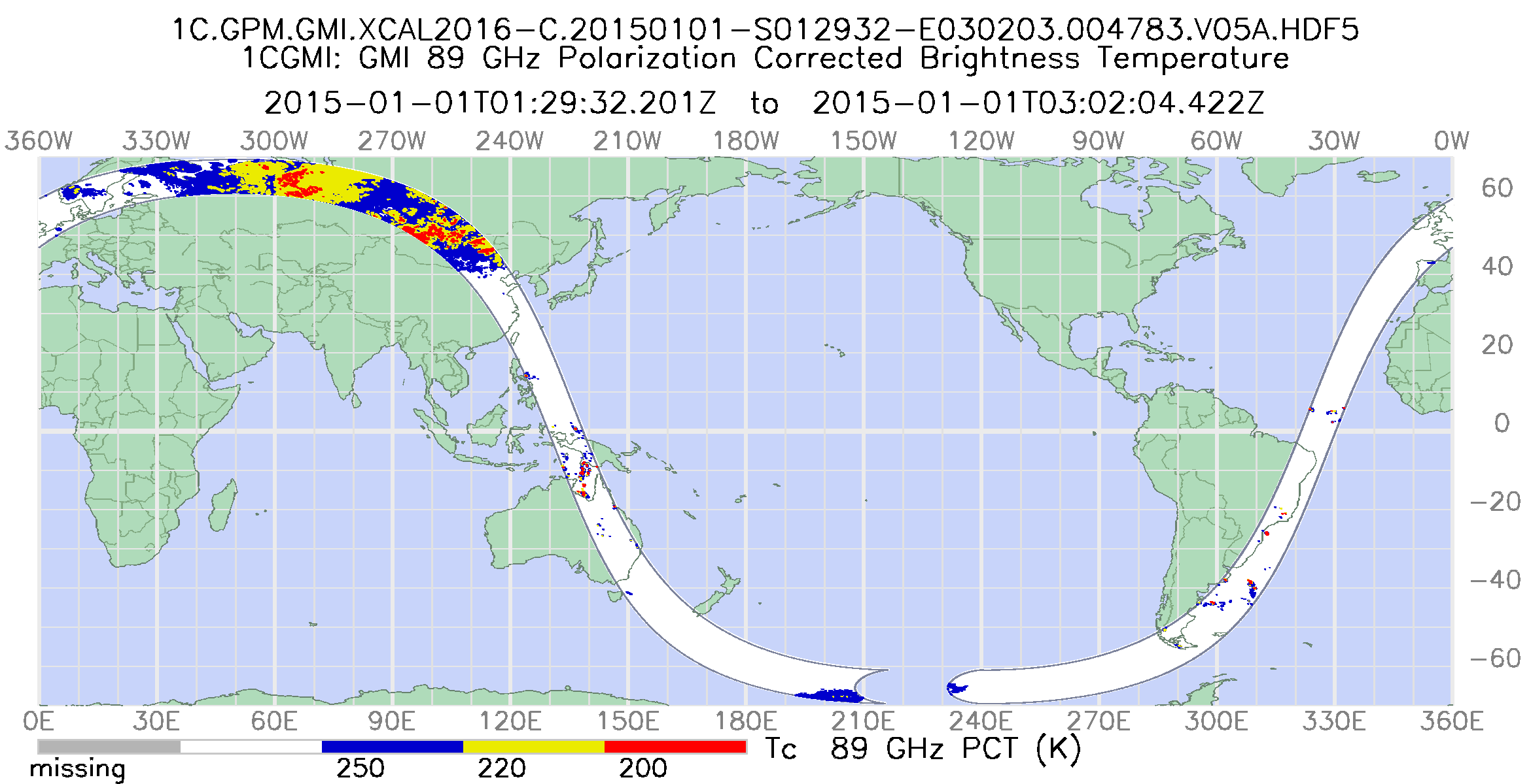
GPM GMI Common Calibrated Brightness Temperatures Collocated L1C 1.5 hours 13 km V07 (GPM_1CGPMGMI) at GES DISC recent views
National Aeronautics and Space Administration —
Version 07 is the current version of the data set. Older versions will no longer be available and have been superseded by Version 07. All 1C products have a common... -
Federal
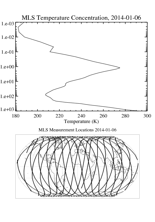
MLS/Aura Level 2 Temperature V004 (ML2T) at GES DISC recent views
National Aeronautics and Space Administration —
ML2T is the EOS Aura Microwave Limb Sounder (MLS) standard product for temperature derived from radiances measured by the 118 and 240 GHz radiometers. The data... -
Federal
Global Landslide Nowcast from LHASA L4 1 day 1 km x 1 km version 2.0.0 (Global_Landslide_Nowcast) at GES DISC recent views
National Aeronautics and Space Administration —
The Global Landslide Nowcast addresses the need for real-time situational awareness of landslide hazard. The Landslide Hazard Assessment for Situational Awareness... -
Federal
VISSR/SMS-2 Level 1 Atmospheric and Oceanographic Image Processing System (AOIPS) Data V001 (VISSRSMS2L1AOIPS) at GES DISC recent views
National Aeronautics and Space Administration —
VISSRSMS2L1AOIPS is the Visible Infrared Spin-Scan Radiometer (VISSR) Level 1 Atmospheric and Oceanographic Image Processing System (AOIPS) data product from the... -
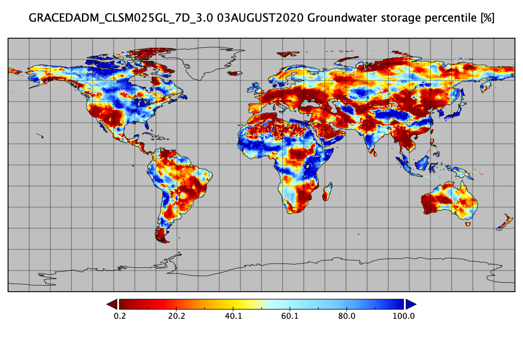
Federal
Groundwater and Soil Moisture Conditions from GRACE and GRACE-FO Data Assimilation L4 7-days 0.25 x 0.25 degree Global V3.0 (GRACEDADM_CLSM025GL_7D) at GES DISC recent views
National Aeronautics and Space Administration —
Scientists at NASA Goddard Space Flight Center generate groundwater and soil moisture drought indicators each week. They are based on terrestrial water storage... -
Federal
IMERG and LHASA Global Landslide Exposure Maps 1.0 recent views
National Aeronautics and Space Administration —
The Landslide Hazard Assessment for Situational Awareness (LHASA) model identifies locations with high potential for landslide occurrence at a daily temporal... -
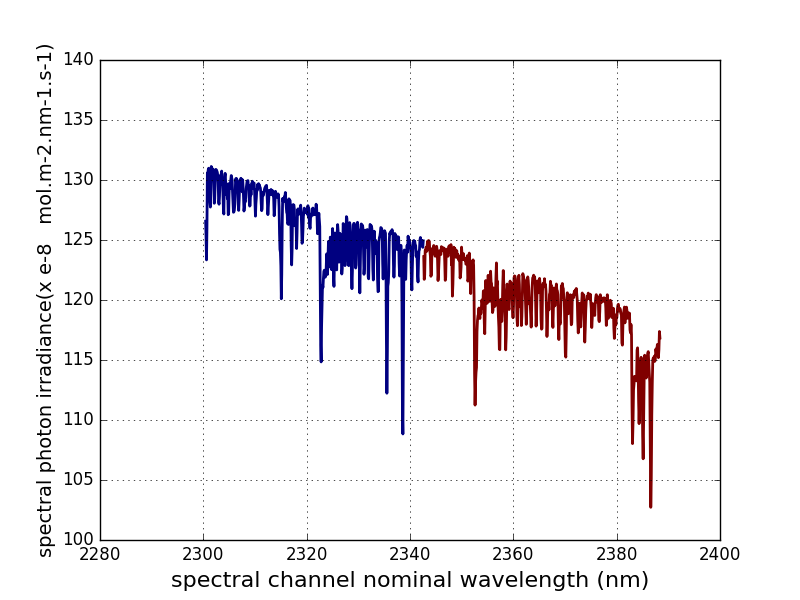
Federal
Sentinel-5P TROPOMI Irradiance product SWIR module L1B V2 (S5P_L1B_IR_SIR) at GES DISC recent views
National Aeronautics and Space Administration —
The Copernicus Sentinel-5 Precursor (Sentinel-5P or S5P) satellite mission is one of the European Space Agency's (ESA) new mission family - Sentinels, and it is a... -
Federal
SCAMS/Nimbus-6 Images of Brightness Temperatures, Water Vapor and Temperature on 70-mm Film V001 (SCAMSN6IM) at GES DISC recent views
National Aeronautics and Space Administration —
The SCAMSN6IM data product consists of images of brightness temperatures, water vapor and temperature on 70 mm film strips from the Nimbus-6 Scanning Microwave... -
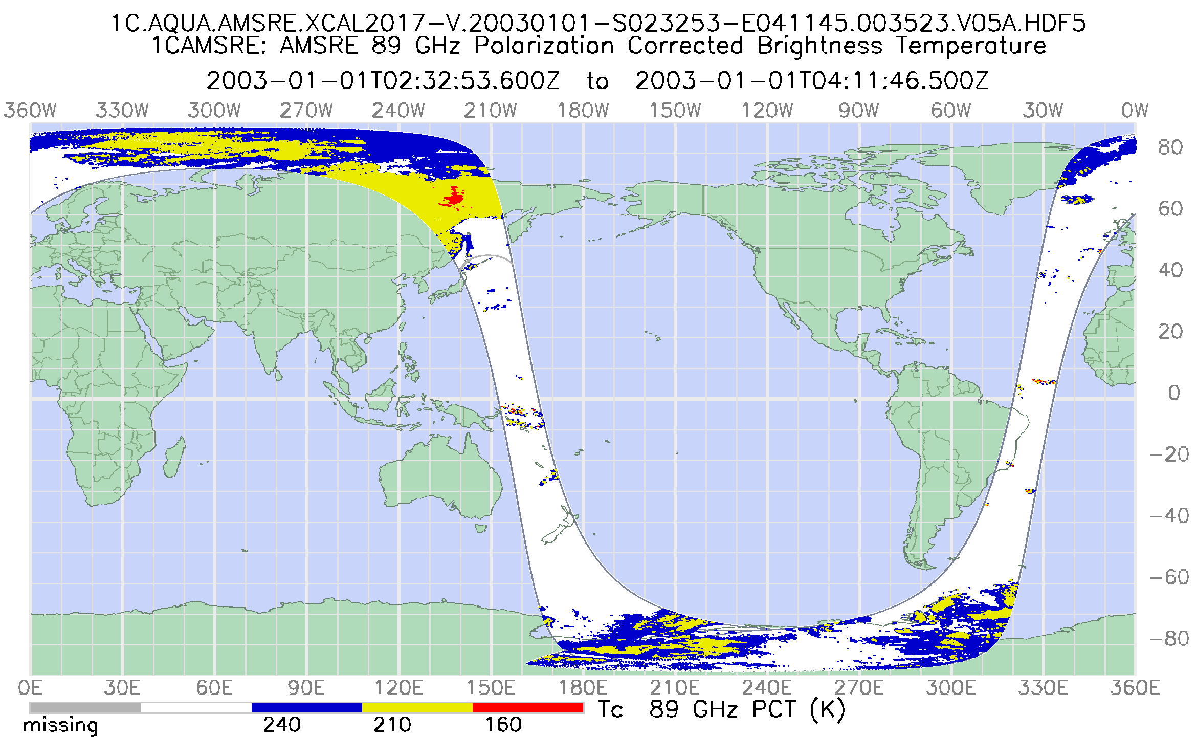
Federal
GPM AMSR-E on AQUA Common Calibrated Brightness Temperatures L1C 1.5 hours 10.5 km V07 (GPM_1CAQUAAMSRE) at GES DISC recent views
National Aeronautics and Space Administration —
All 1C products have a common L1C data structure, simple and generic. Each L1C swath includes scan time, latitude and longitude, scan status, quality, incidence...

Official websites use .gov
A
.gov website belongs to an official government
organization in the United States.
Secure .gov websites use HTTPS
A
lock (
) or https:// means you’ve safely connected to
the .gov website. Share sensitive information only on official,
secure websites.