
-
Federal
OCO-2 Level 2 geolocated XCO2 retrievals results, physical model V11.2 (OCO2_L2_Standard) at GES DISC
National Aeronautics and Space Administration —
Version 11.2 is the current version of the data set. Older versions will no longer be available and are superseded by Version 11.2. The Orbiting Carbon Observatory is... -
Federal
Sentinel-5P TROPOMI Tropospheric NO2 1-Orbit L2 7km x 3.5km V1 (S5P_L2__NO2___) at GES DISC
National Aeronautics and Space Administration —
Starting from August 6th in 2019, Sentinel-5P TROPOMI along-track high spatial resolution (~5.5km at nadir) has been implemented. For data after August 6th of 2019,... -
Federal
OCO-3 Level 2 geolocated XCO2 retrieval results and algorithm diagnostic information, Forward Processing V11 (OCO3_L2_Diagnostic) at GES DISC
National Aeronautics and Space Administration —
Version 11 is the current version of the data set. Older versions will no longer be available and are superseded by Version 11. The Orbiting Carbon Observatory -3... -
Federal
Sentinel-5P TROPOMI Methane CH4 1-Orbit L2 7km x 7km V1 (S5P_L2__CH4___) at GES DISC
National Aeronautics and Space Administration —
Starting from August 6th in 2019, Sentinel-5P TROPOMI along-track high spatial resolution (~5.5km at nadir) has been implemented. For data after August 6th of 2019,... -
Federal
OCO-2 Level 0 spacecraft attitude data V11 (OCO2_Att) at GES DISC
National Aeronautics and Space Administration —
Version 11 is the current version of the data set. Older versions will no longer be available and are superseded by Version 11. The Orbiting Carbon Observatory is the... -
Federal
OCO-2 Level 2 CO2 prior based on CO2 monthly flask record, global meteorology, and age of air V11.2 (OCO2_L2_CO2Prior) at GES DISC
National Aeronautics and Space Administration —
Version 11.2 is the current version of the data set. Older versions will no longer be available and are superseded by Version 11.2. The Orbiting Carbon Observatory is... -
Federal
Sentinel-5P TROPOMI Aerosol Layer Height 1-Orbit L2 7km x 3.5km V1 (S5P_L2__AER_LH) at GES DISC
National Aeronautics and Space Administration —
Starting from August 6th in 2019, Sentinel-5P TROPOMI along-track high spatial resolution (~5.5km at nadir) has been implemented. For data after August 6th of 2019,... -
Federal
OCO-2 Level 1B calibrated, geolocated calibration spectra V11.2 (OCO2_L1B_Calibration) at GES DISC
National Aeronautics and Space Administration —
Version 11.2 is the current version of the data set. Older versions will no longer be available and are superseded by Version 11.2. The Orbiting Carbon Observatory is... -
Federal
Sentinel-5P TROPOMI Near-Real-Time (NRT) Carbon Monoxide CO Column 1-Orbit L2 5.5km x 7km V2 (S5P_L2__CO_____HiR_NRT) at GES DISC
National Aeronautics and Space Administration —
The Sentinel-5P TROPOMI Near Real Time (NRT) Carbon Monoxide CO Column 1-Orbit L2 5.5km x 7km V2 (S5P_L2__CO_HiR_NRT) at GES DISC is the near real time version of the... -
Federal
OCO-3 Level 2 CO2 prior based on CO2 monthly flask record, global meteorology, and age of air, Forward Processing V11 (OCO3_L2_CO2Prior) at GES DISC
National Aeronautics and Space Administration —
Version 11 is the current version of the data set. Older versions will no longer be available and are superseded by Version 11. The Orbiting Carbon Observatory -3... -
Federal
TOVS GLA DAILY GRIDS from NOAA-10 V01 (TOVSADNG) at GES DISC
National Aeronautics and Space Administration —
This dataset (TOVSADNG) contains the TIROS Operational Vertical Sounder (TOVS) level 3 geophysical parameters derived using data from NOAA-10 and the physical... -
Federal
OCO-2 Level 2 spatially ordered geolocated retrievals screened using the A-band Preprocessor V11.2 (OCO2_L2_ABand) at GES DISC
National Aeronautics and Space Administration —
Version 11.2 is the current version of the data set. Older versions will no longer be available and are superseded by Version 11.2. The Orbiting Carbon Observatory is... -
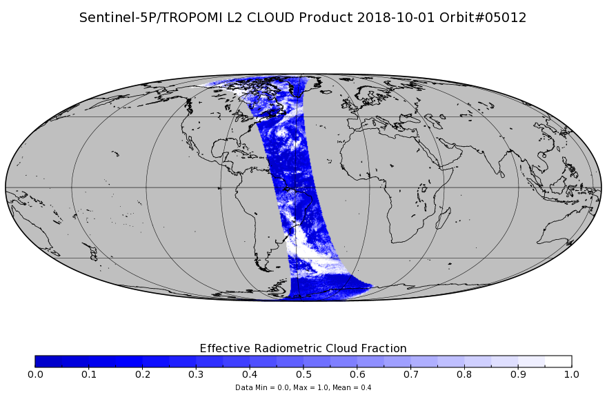
Federal
Sentinel-5P TROPOMI Cloud 1-Orbit L2 7km x 3.5km V1 (S5P_L2__CLOUD_) at GES DISC
National Aeronautics and Space Administration —
Starting from August 6th in 2019, Sentinel-5P TROPOMI along-track high spatial resolution (~5.5km at nadir) has been implemented. Starting from July 13th in 2020,... -
Federal
OCO-3 Level 2 CO2 prior based on CO2 monthly flask record, global meteorology, and age of air, Forward Processing V10 (OCO3_L2_CO2Prior) at GES DISC
National Aeronautics and Space Administration —
Version 10 is the current version of the data set. Older versions will no longer be available and are superseded by Version 10. The Orbiting Carbon Observatory -3... -
Federal
Legates Surface and Ship Observations of Precipitation Climatology 0.5 x 0.5 degree V1 (RAIN_LEGATES) at GES DISC
National Aeronautics and Space Administration —
The Legates Surface and Shipboard Rain Gauge Observations data set consists of a global climatology of monthly mean precipitation values. A global climatology of mean... -
Federal
TRMM Ground Validation Radar Site Rain Type Map L2 1 hour 2 km V7 (TRMM_2A54UW) at GES DISC
National Aeronautics and Space Administration —
This dataset is part of the University of Washington TRMM Ground Validation products. Instantaneous convective-stratiform cartesian grid based on baseUW. Values are 0... -
Federal
OCO-2 Level 1A collated, parsed, science or calibration data V11.2 (OCO2_L1aIn_Sample) at GES DISC
National Aeronautics and Space Administration —
Version 11.2 is the current version of the data set. Older versions will no longer be available and are superseded by Version 11.2. The Orbiting Carbon Observatory is... -
Federal
OMI/Aura and MODIS/Aqua Merged Cloud Product 1-Orbit L2 Swath 13x24 km V003 (OMMYDCLD) at GES DISC NGDA
National Aeronautics and Space Administration —
The OMI/Aura and MODIS/Aqua Merged Cloud Product 1-Orbit L2 Swath 13x24 km (OMMYDCLD) is a Level-2 orbital product that combines cloud parameters retrieved by the... -
Federal
TOVS GLA 5 DAY GRIDS from NOAA-11 V01 (TOVSA5NH) at GES DISC
National Aeronautics and Space Administration —
This dataset (TOVSA5NH) contains the TIROS Operational Vertical Sounder (TOVS) level 3 geophysical parameters derived using data from NOAA-11 and the physical... -
Federal
TOVS GLA 5 DAY GRIDS from TIROSN V01 (TOVSA5TN ) at GES DISC
National Aeronautics and Space Administration —
This dataset (TOVSA5TN) contains the TIROS Operational Vertical Sounder (TOVS) level 3 geophysical parameters derived using data from TIROS-N and the physical...

Official websites use .gov
A
.gov website belongs to an official government
organization in the United States.
Secure .gov websites use HTTPS
A
lock (
) or https:// means you’ve safely connected to
the .gov website. Share sensitive information only on official,
secure websites.