

129 datasets found for ""Soil Surveys""
-
Federal
Predicted Ecological States of the Semiarid Warm Sandy and Loamy Uplands Ecological Site Group in the Upper Colorado River Basin, Based on Vegetation Functional Group Cover Data from 2021
Department of the Interior —
This dataset provides a predictive ecological state map for the Southwest Sandy and Loamy Uplands Ecological Site Group (ESG). We developed a machine learning... -
Federal
Summaries of Selected SSURGO Soil Attributes Within the Lake Michigan Diversion Accounting (LMDA) System
Department of the Interior —
As part of the Lake Michigan Diversion Accounting (LMDA), the U.S. Army Corps of Engineers, Chicago District (USACE-Chicago) uses Hydrological Simulation Program-... -
Federal
Dikes of the Lake Tahoe Basin
Department of the Interior —
These data present a ground-water inventory of existing geospatial data and other information needed to determine the extent and characteristics of the aquifers in... -
Federal
SAFARI 2000 Organic Soil Carbon and Nitrogen Data (Zinke et al.)
National Aeronautics and Space Administration —
The data set contains a subset of the Worldwide Organic Soil Carbon and Nitrogen (Zinke et al. 1986) data set for southern Africa. The data were obtained from soil... -
Federal
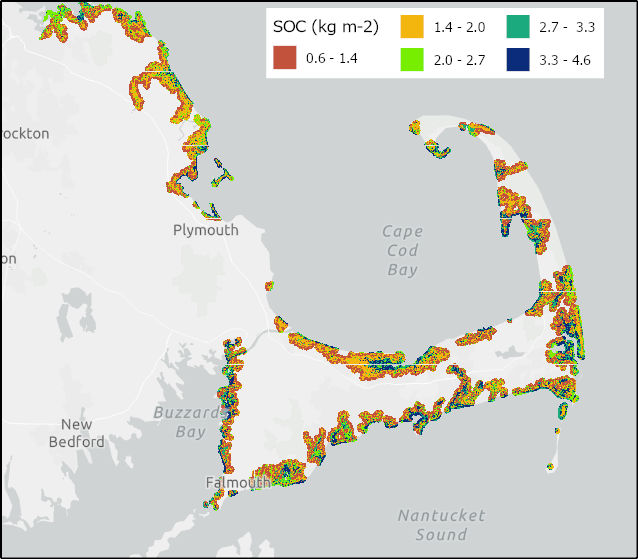
Soil Organic Carbon Distributions in Tidal Wetlands of the Northeastern USA
National Aeronautics and Space Administration —
This dataset provides estimates of soil organic carbon (SOC) in tidal wetlands for the northeastern United States. The data cover the period 1998-2018. Northeastern... -
Federal
Evapotranspiration (ET) at Dead River forested wetland site, monthly data, Hillsborough County, Florida, December 2009 - February 2016
Department of the Interior —
The data set consists of evapotranspiration measurements made at the USGS Dead River forested wetland climate station beginning November 21, 2009 and ending February... -
Federal
Evapotranspiration (ET) at Dead River forested wetland site, 30-minute data, Hillsborough County, Florida, December 2009 - February 2016
Department of the Interior —
The data set consists of evapotranspiration measurements made at the USGS Dead River forested wetland climate station beginning November 21, 2009 and ending February... -
Federal
Grain-size data from vibracores collected in 2014 from Barnegat Bay, New Jersey
Department of the Interior —
In response to the 2010 Governor’s Action Plan to clean up the Barnegat Bay–Little Egg Harbor (BBLEH) estuary in New Jersey, the U.S. Geological Survey (USGS)... -
Federal
Potential productivity and change for big bluestem in the Great Plains Landscape Conservation Cooperative area
Department of the Interior —
This data set includes the relative production scenarios for big bluestem [3.08(Temp) -0.41(Precip)+0.14(Silt) - 0.16(Temp)^2 -31.9]; this is the model from Epstein,...
129 datasets found for ""Soil Surveys""