

90 datasets found
-
Federal
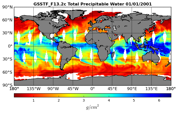
Goddard Satellite-Based Surface Turbulent Fluxes, 0.25 x 0.25 deg, Daily Grid F13 V3 (GSSTF_F13) at GES DISC recent views
National Aeronautics and Space Administration —
These data are part of the Goddard Satellite-based Surface Turbulent Fluxes Version 3 (GSSTF3) Dataset recently produced through a MEaSURES funded project led by Dr.... -
Federal
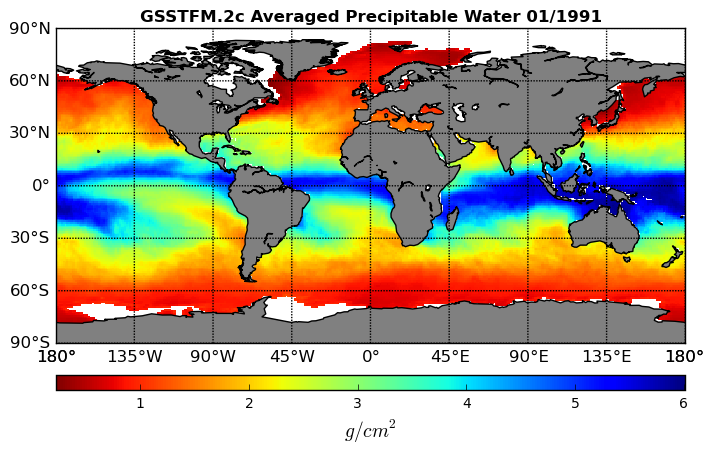
Goddard Satellite-Based Surface Turbulent Fluxes, 1x1 deg Monthly Grid, Set1 and Interpolated Data V2c (GSSTFM) at GES DISC recent views
National Aeronautics and Space Administration —
These data are the Goddard Satellite-based Surface Turbulent Fluxes Version-2c Dataset recently produced through a MEaSUREs funded project led by Dr. Chung-Lin Shie... -
Federal
PISTON 2019 Research Vessel (RV) Sally Ride Data recent views
National Aeronautics and Space Administration —
PISTON-ONR-NOAA_RVSallyRide_2019 is the Propagation of Intra-Seasonal Tropical Oscillations (PISTON) 2019 Research Vessel (RV) Sally Ride data product. This product... -
Federal
MERRA-2 tavgU_2d_slv_Nx: 2d,diurnal,Time-Averaged,Single-Level,Assimilation,Single-Level Diagnostics 0.625 x 0.5 degree V5.12.4 (M2TUNXSLV) at GES DISC recent views
National Aeronautics and Space Administration —
M2TUNXSLV (or tavgU_2d_slv_Nx) is a time-averaged 2-dimensional monthly diurnal means data collection in Modern-Era Retrospective analysis for Research and... -
Federal
WHOI mooring CTD, surface flux and meterorological data for the SPURS-1 N. Atlantic field campaign recent views
National Aeronautics and Space Administration —
The SPURS (Salinity Processes in the Upper Ocean Regional Study) project is an oceanographic process study and associated field program that aim to elucidate key... -
Federal
TOVS GLA MONTHLY GRIDS from NOAA-10 V01 (TOVSAMNG) at GES DISC recent views
National Aeronautics and Space Administration —
This dataset (TOVSAMNG) contains the TIROS Operational Vertical Sounder (TOVS) level 3 geophysical parameters derived using data from NOAA-10 and the physical... -
Federal
Environmental Working Group Joint U.S.-Russian Arctic Sea Ice Atlas, Version 1 recent views
National Aeronautics and Space Administration —
Note: The Russian chart component of this product has been replaced and updated by Sea Ice Charts of the Russian Arctic in Gridded Format, 1933-2006 and the U.S chart... -
Federal
GRACE NON-TIDAL OCEAN GEOPOTENTIAL COEFFICIENTS JPL RELEASE 6.0 GAB recent views
National Aeronautics and Space Administration —
FOR EXPERT USE ONLY. This dataset contains estimates of geopotential field derived from the Gravity Recovery and Climate Experiment (GRACE) mission measurements and a... -
Federal
MERRA-2 tavgM_2d_slv_Nx: 2d,Monthly mean,Time-Averaged,Single-Level,Assimilation,Single-Level Diagnostics 0.625 x 0.5 degree V5.12.4 (M2TMNXSLV) at GES DISC recent views
National Aeronautics and Space Administration —
M2TMNXSLV (or tavgM_2d_slv_Nx) is a time-averaged 2-dimensional monthly mean data collection in Modern-Era Retrospective analysis for Research and Applications... -
Federal
GRACE-FO Level-2 Monthly Geopotential Spherical Harmonics GFZ Release 6.1 (RL06.1) recent views
National Aeronautics and Space Administration —
FOR EXPERT USE ONLY. This dataset contains estimates of the total month-by-month geopotential of the Earth, derived from the Gravity Recovery and Climate Experiment...
90 datasets found