
-
Federal
Irrigated Acreage Geodatabase Within the Basin and Range Carbonate-Rock Aquifer System, White Pine County, Nevada, and Adjacent Areas in Nevada and Utah
Department of the Interior —
Accurate delineations of irrigated acreage are critical in the development of water-use estimates and in determining an accurate water budget for the hydrographic... -
Federal
An Unvegetated to Vegetated Ratio (UVVR) for coastal wetlands of the Conterminous United States (2014-2018)
Department of the Interior —
This USGS Data Release represents geospatial data sets which were created to produce an Unvegetated to Vegetated Ratio (UVVR) for coastal wetlands of the conterminous... -
Federal
Geospatial files associated with the delineation and characterization of surface-moisture zones in the vicinity of mapped springs in Harney County, Oregon, 2017
Department of the Interior —
This data collection includes spatial and tabular datasets related to the delineation and characterization of surface moisture zones (SMZs) in the vicinity of springs... -
Federal
Mississippi barrier island land area change 1984-2016
Department of the Interior —
The analyses of landscape change presented in this dataset use Landsat Thematic Mapper (TM), Enhanced Thematic Mapper (ETM) and Operational Land Imager (OLI) to... -
Federal
LBA-ECO ND-01 Fractional Land Cover Images, Rondonia, Brazil: 1984-2000
National Aeronautics and Space Administration —
This data set provides fractional land cover type images for shade, green vegetation (GV), non-photosynthetic vegetation (NPV), and soil for the regions of JiParana,... -
Federal
LBA-ECO ND-01 Streamwater and Watershed Characteristics, Rondonia, Brazil: 1998-1999
National Aeronautics and Space Administration —
This data set provides the results of (1) synoptic streamwater sampling and analyses from numerous sites across Rondonia and (2) corresponding watershed... -
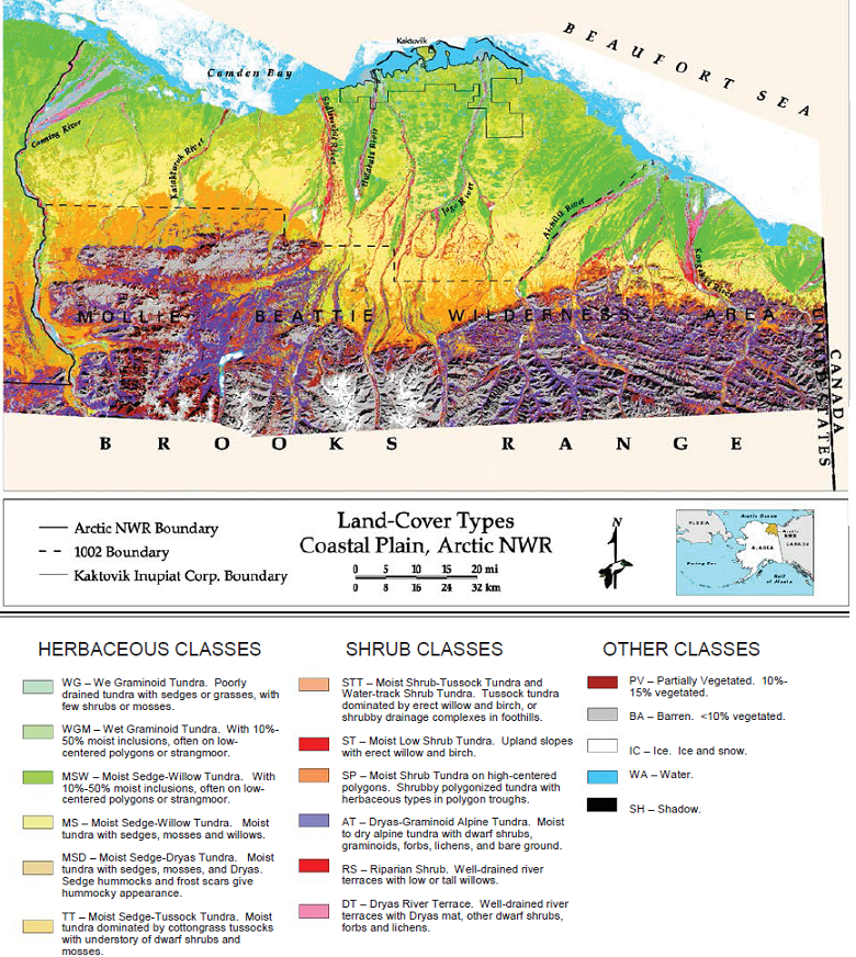
Federal
Land Cover and Vegetation Map, Arctic National Wildlife Refuge
National Aeronautics and Space Administration —
This data set provides a landcover map with 16 landcover classes for the northern coastal plain of the the Arctic National Wildlife Refuge (ANWR) on the North Slope... -
Federal
SMEX03 Landsat Thematic Mapper NDVI and NDWI: Georgia, Version 1
National Aeronautics and Space Administration —
This Normalized Difference Vegetation Index (NDVI) and Normalized Difference Water Index (NDWI) data set was developed from Landsat 5 Thematic Mapper (TM) data for... -
Federal
SMEX03 Landsat Thematic Mapper Imagery: Georgia, Version 1
National Aeronautics and Space Administration —
This data set provides imagery developed from Landsat 5 Thematic Mapper (TM) data for use in studying land cover features during the Soil Moisture Experiment 2003... -
Federal
SMEX02 Landsat Thematic Mapper Imagery, Iowa, Version 1
National Aeronautics and Space Administration —
This data set provides imagery developed from Landsat 5 and 7 Thematic Mapper (TM) data for use in studying land cover features during the Soil Moisture Experiment... -
Federal
SMEX04 Landsat Thematic Mapper Imagery, Arizona, Version 1
National Aeronautics and Space Administration —
This data set provides imagery developed from Landsat 5 Thematic Mapper (TM) data for use in studying land cover features during the Soil Moisture Experiment 2004... -
Federal
Classification of evapotranspiration units in major discharge areas of Death Valley regional
Department of the Interior —
The raster-based classification of evapotranspiration (ET) units is for nine major discharge areas in the Death Valley regional flow system. The ET units delineate... -
Federal
Imagery data for the Vegetation Mapping Inventory Project of Carlsbad Caverns National Park
Department of the Interior —
This reference contains the imagery data used in the completion of the baseline vegetation inventory project for the NPS park unit. Orthophotos, raw imagery, and... -
Federal
NOAA's Coastal Change Analysis Program (C-CAP) 2016 Regional Land Cover Data - Coastal United States
National Oceanic and Atmospheric Administration, Department of Commerce —
The NOAA Coastal Change Analysis Program (C-CAP) produces national standardized land cover and change products for the coastal regions of the U.S. C-CAP products... -
Federal
Coastal Change Analysis Program (C-CAP) 2015/2016 Regional Land Cover Data - Contiguous United States
National Oceanic and Atmospheric Administration, Department of Commerce —
NOAA's Coastal Change Analysis Program (C-CAP) produces national standardized land cover and land change information for the coastal regions of the U.S. C-CAP... -
Federal
NOAA's Coastal Change Analysis Program (C-CAP) 1992 Regional Land Cover Data - Coastal United States
National Oceanic and Atmospheric Administration, Department of Commerce —
The NOAA Coastal Change Analysis Program (C-CAP) produces national standardized land cover and change products for the coastal regions of the U.S. C-CAP products... -
Federal
NOAA's Coastal Change Analysis Program (C-CAP) 1985 Regional Land Cover Data - Coastal United States
National Oceanic and Atmospheric Administration, Department of Commerce —
The NOAA Coastal Change Analysis Program (C-CAP) produces national standardized land cover and change products for the coastal regions of the U.S. C-CAP products...

Official websites use .gov
A
.gov website belongs to an official government
organization in the United States.
Secure .gov websites use HTTPS
A
lock (
) or https:// means you’ve safely connected to
the .gov website. Share sensitive information only on official,
secure websites.