
-
Federal
Last of the Wild Project, Version 3 (LWP-3): 2009 Human Footprint, 2018 Release recent views
National Aeronautics and Space Administration —
The 2009 Human Footprint, 2018 Release provides a global map of the cumulative human pressure on the environment in 2009, at a spatial resolution of ~1 km. The human... -
Federal
ENVISAT MERIS Global Mapped Inherent Optical Properties (IOP) Data, version R2022.0 recent views
National Aeronautics and Space Administration —
MERIS (Medium Resolution Imaging Spectrometer) is a programmable, medium-spectral resolution, imaging spectrometer operating in the solar reflective spectral range.... -
Federal
Forest Inventory and Biophysical Measurements, Brazilian Amazon, 2009-2018 recent views
National Aeronautics and Space Administration —
This dataset provides the complete catalog of forest inventory and biophysical measurements collected over selected forest research sites across the Amazon rainforest... -
Federal
Classification of Global Forests for IPCC Aboveground Biomass Tier 1 Estimates, 2020 recent views
National Aeronautics and Space Administration —
This dataset provides classes of global forests delineated by status/condition in 2020 at approximately 30-m resolution. The data support generating Tier 1 estimates... -
Federal
BOREAS RSS-02 Extracted Reflectance Factors Derived from ASAS Imagery recent views
National Aeronautics and Space Administration —
Contains calculated bidirectional reflectance factor means derived from extractions of C130-based ASAS measurements made during BOREAS. -
Federal
Tidal Wetlands Soil Organic Carbon and Estuarine Characteristics, USA, 1972-2015 recent views
National Aeronautics and Space Administration —
This dataset provides a synthesis of soil organic carbon (SOC) estimates and a variety of other environmental information from tidal wetlands within estuaries in the... -
Federal
Forest Carbon Stocks and Fluxes from the NFCMS, Conterminous USA, 1990-2010 recent views
National Aeronautics and Space Administration —
This dataset, derived from the National Forest Carbon Monitoring System (NFCMS), provides estimates of forest carbon stocks and fluxes in the form of aboveground... -
Federal
ABoVE: Modeled Top Cover by Plant Functional Type over Alaska and Yukon, 1985-2020 recent views
National Aeronautics and Space Administration —
This dataset contains data files of modeled top cover estimates by plant functional type (PFT) for the Arctic and Boreal Alaska and Yukon regions. Estimates are... -
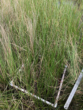
Federal
Ground-Based Vegetation Community Photos, Toolik Lake Area, Alaska, 2014-2015 recent views
National Aeronautics and Space Administration —
This dataset contains 731 ground-based nadir vegetation community and ground surface photographs of selected field plots taken as ground reference data for vegetation... -
Federal
Merged Sentinel-3A and Sentinel-3B OLCI Global Mapped Cyanobacteria Index (CI) - Near Real-time (NRT) Data, version 5.0 recent views
National Aeronautics and Space Administration —
The Ocean Biology DAAC produces near real-time (quicklook) products using the best-available combination of ancillary data from meteorological and ozone data. As... -
Federal
Delta-X: Aboveground Biomass and Necromass across Wetlands, MRD, Louisiana, 2021, V2 recent views
National Aeronautics and Space Administration —
This dataset contains total aboveground biomass (AGB) and necromass (AGN), and total carbon, total nitrogen, and total phosphorus content of aboveground biomass (AGB)... -
Federal
BOREAS Site and Area Geographic Coordinate Information recent views
National Aeronautics and Space Administration —
Geographic coordinate and other site information from several sources throughout the experiment period. The final set of information is organized into two data sets... -
Federal
Urban Biogenic CO2 fluxes: GPP, Reco and NEE Estimates from SMUrF, 2010-2019 NGDA recent views
National Aeronautics and Space Administration —
This dataset contains estimates of biogenic CO2 flux components at 0.05 degree resolution from the Solar-Induced Fluorescence (SIF) for Modeling Urban biogenic Fluxes... -
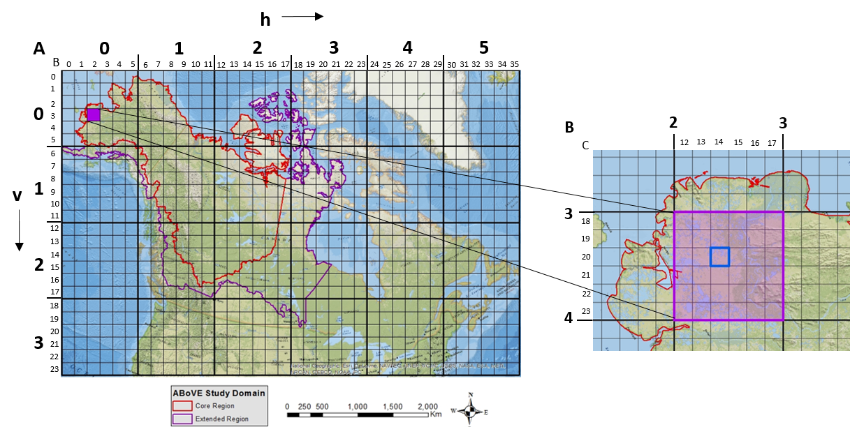
Federal
ABoVE: Study Domain and Standard Reference Grids, Version 2 recent views
National Aeronautics and Space Administration —
The Arctic - Boreal Vulnerability Experiment (ABoVE) has developed two standardized spatial data products to expedite coordination of research activities and to... -
Federal
SAFARI 2000 Historical Fire Maps, Kruger National Park, 1992-2001 recent views
National Aeronautics and Space Administration —
Kruger National Park (KNP) was established in 1898 to protect wildlife on nearly 2 million hectares of the South African Lowveld. Savanna fires are common in the... -
Federal
Global Food Security-support Analysis Data (GFSAD) Cropland Extent-Product 2015 Validation 30 m V001 recent views
National Aeronautics and Space Administration —
The NASA Making Earth System Data Records for Use in Research Environments (MEaSUREs) (https://earthdata.nasa.gov/community/community-data-system-programs/measures-... -
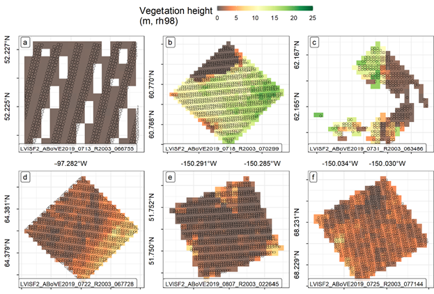
Federal
ABoVE: LVIS L3 Gridded Vegetation Structure across North America, 2017 and 2019 recent views
National Aeronautics and Space Administration —
This dataset provides Level 3 (L3) footprint-level gridded metrics and attributes collected from NASA's Land, Vegetation, and Ice Sensor (LVIS)-Facility instrument... -
Federal
ABoVE: Characterization of Carbon Dynamics in Burned Forest Plots, NWT, Canada, 2014 recent views
National Aeronautics and Space Administration —
This dataset provides field data from boreal forests in the Northwest Territories (NWT), Canada, that were burned by wildfires in 2014. During fieldwork in 2015, 211... -
Federal
CMS: Forest Biomass and Productivity, 1-degree and 5-km, Conterminous US, 2005 recent views
National Aeronautics and Space Administration —
Notice: This data set and guide were updated on June 30, 2014 to correct an error in the reported units. The data values were not changed.Spatially-gridded estimates... -
Federal
Aboveground Biomass Density for High Latitude Forests from ICESat-2, 2020 recent views
National Aeronautics and Space Administration —
This dataset provides estimates of Aboveground dry woody Biomass Density (AGBD) for high northern latitude forests at a 30-m spatial resolution. It is designed both...

Official websites use .gov
A
.gov website belongs to an official government
organization in the United States.
Secure .gov websites use HTTPS
A
lock (
) or https:// means you’ve safely connected to
the .gov website. Share sensitive information only on official,
secure websites.