
-
Federal
The Olympia & Pacific Oyster Data Portal recent views
National Oceanic and Atmospheric Administration, Department of Commerce —
Locations (i.e., "records") of Ostrea lurida (Olympia oysters) and Magallana gigas (Pacific oysters) observed 1602 to 2020 along the west coast of North America.... -
Federal
Social Vulnerability Index (SoVI) for South Carolina based on 2000 Census Block Groups recent views
National Oceanic and Atmospheric Administration, Department of Commerce —
This data depicts the social vulnerability of South Carolina census block groups to environmental hazards. Data were culled primarily from the 2000 Decennial Census. -
Federal
Gridded Population of the World, Version 4 (GPWv4): Population Density, Revision 11 recent views
National Aeronautics and Space Administration —
The Gridded Population of the World, Version 4 (GPWv4): Population Density, Revision 11 consists of estimates of human population density (number of persons per... -
Federal
Georeferenced U.S. County-Level Population Projections, Total and by Sex, Race and Age, Based on the SSPs, 2020-2100 recent views
National Aeronautics and Space Administration —
The Georeferenced U.S. County-Level Population Projections, Total and by Sex, Race and Age, Based on the SSPs, 2020-2100 consists of county-level population... -
Federal
Demographic Trends (1970-2010) for Coastal Geographies recent views
National Oceanic and Atmospheric Administration, Department of Commerce —
The Demographic Trends (1970-2010) were derived from Census Block Group Data for 13 different coastal geographies. For a full listing of the geographies available,... -
Federal
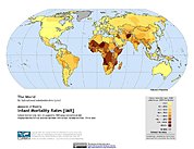
Global Subnational Infant Mortality Rates, Version 2.01 recent views
National Aeronautics and Space Administration —
The Global Subnational Infant Mortality Rates, Version 2.01 consist of Infant Mortality Rate (IMR) estimates for 234 countries and territories, 143 of which include... -
Federal
West Africa Coastal Vulnerability Mapping: Population Projections, 2030 and 2050 recent views
National Aeronautics and Space Administration —
The West Africa Coastal Vulnerability Mapping: Population Projections, 2030 and 2050 data set is based on an unreleased working version of the Gridded Population of... -
Federal
ECOHAB: Kamykowski_D- Florida Process Cruise 1998-11-16 to 1998-11-19 Karenia brevis counts, biochemistry and behavior (NCEI Accession 0000534) recent views
National Oceanic and Atmospheric Administration, Department of Commerce —
Water bottle samples were collected from selected depths (variable with station) at 14 stations in the study area. Coulter counts in the 14-28 um size class were... -
Federal
Archive of Census Related Products (ACRP): 1980 SAS Transport Files recent views
National Aeronautics and Space Administration —
The 1980 SAS Transport Files portion of the Archive of Census Related Products (ACRP) contains housing and population demographics from the 1980 Summary Tape File... -
Federal
Alaska's Changing YK Delta: Knowledge Exchange between Elders and Geoscientists, 2018 recent views
National Aeronautics and Space Administration —
This dataset provides a booklet documenting the discussions and outcomes from a knowledge-exchange meeting with Yup'ik elders from the Yukon-Kuskokwim Delta (YKD),... -
Federal
Gridded Population of the World, Version 3 (GPWv3): Population Count Grid recent views
National Aeronautics and Space Administration —
The Gridded Population of the World, Version 3 (GPWv3): Population Count Grid consists of estimates of human population for the years 1990, 1995, and 2000 by 2.5 arc-... -
Federal
Carbon Dioxide (CO2) mole fraction, CO2 flux, and others collected from Salt Lake City CO2 measurement network in Western U.S. from 2001-02-07 to 2015-10-23 (NCEI Accession 0170450) recent views
National Oceanic and Atmospheric Administration, Department of Commerce —
This dataset contains atmospheric measurements of carbon dioxide (CO2) from the Salt Lake City CO2 measurement network from 2001-2015 as well as several supporting... -
Federal
Number of Veterans who Used VA Benefits by State FY2016 recent views
Department of Veterans Affairs —
This file shows the number of Veterans in each state who used each of 7 VA benefits during fiscal year 2016. It also shows the unique count of users across all VA... -
Federal
Housing Opportunities for Persons with AIDS (HOPWA) Grantee Areas recent views
Department of Housing and Urban Development —
The Housing Opportunities for Persons with AIDS (HOPWA) program is the only Federal program dedicated to address housing needs for low-income persons who are living... -
Federal
Gridded Population of the World, Version 3 (GPWv3): Population Density Grid, Future Estimates recent views
National Aeronautics and Space Administration —
The Gridded Population of the World, Version 3 (GPWv3): Population Density Grid, Future EstimatesFuture Estimates consists of estimates of human population for the... -
Federal
Population Exposure Estimates in Proximity to Nuclear Power Plants, Country-Level Aggregates recent views
National Aeronautics and Space Administration —
The Population Exposure Estimates in Proximity to Nuclear Power Plants, Country-Level Aggregates data set consists of country-level estimates of total, urban, and... -
Federal
Poverty Mapping Project: Global Subnational Infant Mortality Rates recent views
National Aeronautics and Space Administration —
The Poverty Mapping Project: Global Subnational Infant Mortality Rates data set consists of estimates of infant mortality rates for the year 2000. The infant... -
Federal
San Pedro River Aquifer Data Release - Transboundary Aquifer Assessment Program (TAAP) recent views
Department of the Interior —
This is a release of data presented in the report "Binational Study of the Transboundary San Pedro Aquifer", Callegary and others, 2016: Callegary, J.B., Minjárez... -
Federal
National Park Service Alaskan Dall Sheep Survey Units, Francis Singer, 1984 recent views
Department of the Interior —
Dall sheep aerial survey units from the early 1980s by Francis Singer in Noatak National Preserve and Gates of the Arctic National Park and Preserve in Alaska. Dall... -
Federal
Global 1-km Downscaled Population Base Year and Projection Grids Based on the Shared Socioeconomic Pathways, Revision 01 recent views
National Aeronautics and Space Administration —
The Global 1-km Downscaled Population Base Year and Projection Grids Based on the Shared Socioeconomic Pathways, Revision 01, data set consists of global urban,...

Official websites use .gov
A
.gov website belongs to an official government
organization in the United States.
Secure .gov websites use HTTPS
A
lock (
) or https:// means you’ve safely connected to
the .gov website. Share sensitive information only on official,
secure websites.