
-
Federal
Benthic Habitats of Puerto Rico and the U.S. Virgin Islands;Photomosaic of Puerto Rico (Isla de Culebra), 1999
National Oceanic and Atmospheric Administration, Department of Commerce —
Habitat maps of Puerto Rico and the U.S. Virgin Islands were created by visual interpretation of aerial photographs using the Habitat Digitizer Extension. Aerial... -
Federal
Historic Inventory of Acropora Around Puerto Rico and U.S. Virgin Islands
National Oceanic and Atmospheric Administration, Department of Commerce —
Atlantic acroporid corals were listed as threatened under the Endangered Species Act (ESA) of 1973 on May 9, 2006, and a 4(d) rule was final on October 29, 2008,... -
Federal
Water Depth and acoustic backscatter data collected from NOAA Ship Nancy Foster in the US Caribbean/ Puerto Rico and St. Thomas from 2016-04-07 to 2016-04-26 (NCEI Accession 0157612)
National Oceanic and Atmospheric Administration, Department of Commerce —
NOAA's NOS/NCCOS/CCMA Biogeography Team, in collaboration with NOAA Ship Nancy Foster, federal, academic, and private sector partners conducted the 2016 Seafloor... -
Federal
Benthic Habitat Maps of Puerto Rico Prepared by Visual Interpretation from Remote Sensing Imagery Collected by NOAA, 1999
National Oceanic and Atmospheric Administration, Department of Commerce —
This project is a cooperative effort among the National Ocean Service, National Centers for Coastal Ocean Science, Center for Coastal Monitoring and Assessment; the... -
Federal
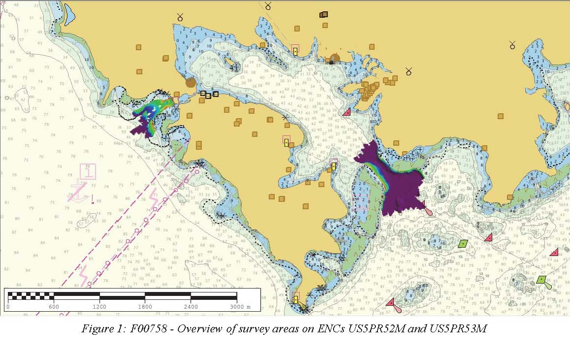
F00758: NOS Hydrographic Survey , 2018-10-30
National Oceanic and Atmospheric Administration, Department of Commerce —
The National Oceanic and Atmospheric Administration (NOAA) has the statutory mandate to collect hydrographic data in support of nautical chart compilation for safe... -
Federal
Puerto Rico Relative Erosion Potential (REP) - 2000
National Oceanic and Atmospheric Administration, Department of Commerce —
The relative erosion potential is an indicator of sediment and pollution runoff from land based on slope, soil type, land cover (circa 2000) and (maximum monthly)... -
Federal
Northeast Puerto Rico and Culebra Island - Geographic Zone Map 2015
National Oceanic and Atmospheric Administration, Department of Commerce —
This geographic zone map was created by interpreting satellite and aerial imagery, seafloor topography (bathymetry model), and the new NEPR Benthic Habitat Map... -
Federal
La Parguera Accuracy Assessment Point Data for Benthic Habitats of Puerto Rico and the U.S. Virgin Islands
National Oceanic and Atmospheric Administration, Department of Commerce —
This project is a cooperative effort among the National Ocean Service, National Centers for Coastal Ocean Science, Center for Coastal Monitoring and Assessment; the... -
Federal
Northeast Puerto Rico and Culebra Island Accuracy Assessment Points - 2015
National Oceanic and Atmospheric Administration, Department of Commerce —
This shapefile denotes the location of underwater photos and videos taken in shallow water (0-35m) benthic habitats surrounding Northeast Puerto Rico and Culebra... -
Federal
Puerto Rico Land-Based Threat to Benthic Habitats
National Oceanic and Atmospheric Administration, Department of Commerce —
This data set describes the potential threat of sediment delivery and land-based sources of pollution to benthic habitats. This dataset is derived from NOAA's study,... -
Federal
Benthic Habitats of Puerto Rico and the U.S. Virgin Islands;Photomosaic of Puerto Rico (East Culebra), 1999
National Oceanic and Atmospheric Administration, Department of Commerce —
Habitat maps of Puerto Rico and the U.S. Virgin Islands were created by visual interpretation of aerial photographs using the Habitat Digitizer Extension. Aerial... -
Federal
NCCOS Assessment: Underwater Video for Ground Validation and Accuracy Assessment of Benthic Habitat Maps of the Insular Shelf South of St. Thomas and St. John, U.S. Virgin Islands, 2010-03-20 to 2017-02-10
National Oceanic and Atmospheric Administration, Department of Commerce —
The presence and absence of the four substrate and four biological cover types were documented at 1,353 locations on the insular shelf south of St. Thomas and St.... -
Federal
1999 Photomosaics of Puerto Rico and U.S. Virgin Islands Utilized to Map Shallow Water Benthic Habitats of the Region
National Oceanic and Atmospheric Administration, Department of Commerce —
Habitat maps of Puerto Rico and the U.S. Virgin Islands were created by visual interpretation of aerial photographs using the Habitat Digitizer Extension. Aerial... -
Federal
La Parguera Accuracy Assessment Point Data for Benthic Habitats of Puerto Rico and the U.S. Virgin Islands
National Oceanic and Atmospheric Administration, Department of Commerce —
This project is a cooperative effort among the National Ocean Service, National Centers for Coastal Ocean Science, Center for Coastal Monitoring and Assessment; the... -
Federal
Northeast Puerto Rico and Culebra Island - Benthic Habitat Map 2015
National Oceanic and Atmospheric Administration, Department of Commerce —
This benthic habitat map was created from a semi-automated habitat mapping process, using a combination of bathymetry, satellite imagery, aerial imagery and...

Official websites use .gov
A
.gov website belongs to an official government
organization in the United States.
Secure .gov websites use HTTPS
A
lock (
) or https:// means you’ve safely connected to
the .gov website. Share sensitive information only on official,
secure websites.