
-
Federal
Palm Beach, Florida Tsunami Forecast Grids for MOST Model
National Oceanic and Atmospheric Administration, Department of Commerce —
The Palm Beach, Florida Forecast Model Grids provides bathymetric data strictly for tsunami inundation modeling with the Method of Splitting Tsunami (MOST) model.... -
Federal
Massachusetts Recreational Fishing Demand Survey
National Oceanic and Atmospheric Administration, Department of Commerce —
Stated preference choice experiment data were collected in 2012 from Massachuestts saltwater recreational fishermen. Saltwater anglers fishing in Massachusetts (MA)... -
Federal
NOAA TIFF Image - 8m Backscatter Mosaic, W00221-222 USVI 2012, Seafloor Characterization of the US Caribbean - Nancy Foster - M-I907-NF-12 (2012), UTM 20N NAD83
National Oceanic and Atmospheric Administration, Department of Commerce —
This image represents a 8 meter resolution backscatter mosaic of of a sharply sloping swath of the St. John Shelf, south of NE Reserve, offshore of Fajardo, Puerto... -
Federal
Habitat classification from multibeam. SEFIS Survey Areas in the South Atlantic Bight, 2012
National Oceanic and Atmospheric Administration, Department of Commerce —
This dataset contains a vector shapefile describing the geomorphology of 21 areas along the shelf edge off the South Atlantic Bight where NOAA South East Fisheries... -
Federal
Atka, Alaska Tsunami Forecast Grids for MOST Model
National Oceanic and Atmospheric Administration, Department of Commerce —
The Atka, Alaska Forecast Grids provides bathymetric data strictly for tsunami inundation modeling with the Method of Splitting Tsunami (MOST) model. MOST is a suite... -
Federal
Cost Earnings Data 2012 - Hawaii Longline
National Oceanic and Atmospheric Administration, Department of Commerce —
The data collection project assessed the economic performance of Hawaii-based longline vessels that made trips in 2012. Operational and vessel costs were collected by... -
Federal
Marine Fisheries Initiative Program (MARFIN) Exploratory surveys for red snapper juveniles off Florida South Atlantic coast from 2012-07-31 to 2012-09-08 (NCEI Accession 0156976)
National Oceanic and Atmospheric Administration, Department of Commerce —
The data set contains information on locations sampled, gears used, and whether red snapper were observed. If a red snapper was caught its total length was recorded. -
Federal
Kailua-Kona, Hawaii Tsunami Forecast Grids for MOST Model
National Oceanic and Atmospheric Administration, Department of Commerce —
The Kailua-Kona, Hawaii Forecast Model Grids provides bathymetric data strictly for tsunami inundation modeling with the Method of Splitting Tsunami (MOST) model.... -
Federal
NOAA TIFF Image - 1m Backscatter Mosaic, W00221-222 USVI 2012, Seafloor Characterization of the US Caribbean - Nancy Foster - M-I907-NF-12 (2012), UTM 20N NAD83
National Oceanic and Atmospheric Administration, Department of Commerce —
This image represents a 1 meter resolution backscatter mosaic of the bathymetry of a reef shelf/bank and the steep slopes and canyons of the NE Reserve, offshore of... -
Federal
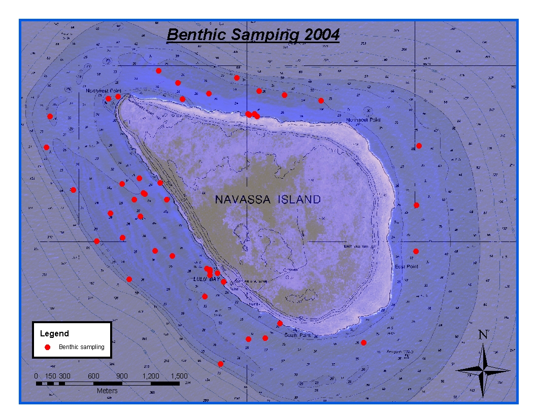
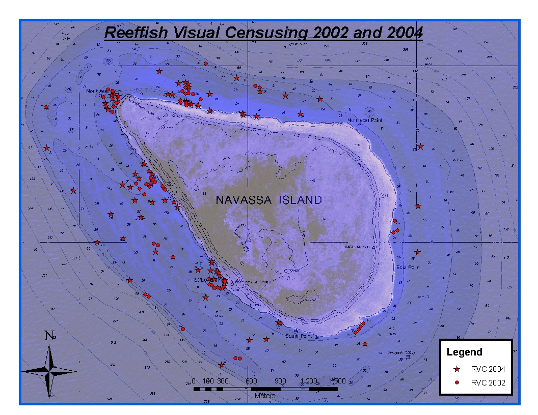
CRCP-Navassa reef assessment
National Oceanic and Atmospheric Administration, Department of Commerce —
Episodic cruises ( every 2 years) were conducted to perform assessments of Navassa Island coral reef resources including reeffish visual census, benthic reef... -
Federal
Hanalei, Hawaii Tsunami Forecast Grids for MOST Model
National Oceanic and Atmospheric Administration, Department of Commerce —
The Hanalei, Hawaii Forecast Model Grids provides bathymetric data strictly for tsunami inundation modeling with the Method of Splitting Tsunami (MOST) model. MOST is... -
Federal
Elfin Cove, Alaska Tsunami Forecast Grids for MOST Model
National Oceanic and Atmospheric Administration, Department of Commerce —
The Elfin Cove, Alaska Forecast Grids provides bathymetric data strictly for tsunami inundation modeling with the Method of Splitting Tsunami (MOST) model. MOST is a... -
Federal
Sensitivity of Coastal Environments and Wildlife to Spilled Oil: Florida Panhandle: ESIP (ESI Shoreline Types - Polygons)
National Oceanic and Atmospheric Administration, Department of Commerce —
The ESIP data set contains vector polygons representing the shoreline and coastal habitats of the Florida Panhandle, classified according to the Environmental... -
Federal
Shallow-Water Benthic Habitats of Southwest Puerto Rico: GeoEye Image po_1700252_PS
National Oceanic and Atmospheric Administration, Department of Commerce —
Shallow-water (<30m) benthic habitat maps of the nearshore marine environment of two areas in Southwest Puerto Rico (PR), including the Guanica Bay/La Parguera... -
Federal
Shallow-Water Benthic Habitats of Southwest Puerto Rico: GeoEye Image po_483895_PS
National Oceanic and Atmospheric Administration, Department of Commerce —
Shallow-water (<30m) benthic habitat maps of the nearshore marine environment of two areas in Southwest Puerto Rico (PR), including the Guanica Bay/La Parguera... -
Federal
Dissolved inorganic carbon, total alkalinity, pH and other variables collected from surface discrete measurements using Coulometer, alkalinity titrator and other instruments from the Philippines from 2012-03-12 to 2015-06-03 (NCEI Accession 0242691)
National Oceanic and Atmospheric Administration, Department of Commerce —
This dataset contains carbonate chemistry data from samples collected across the Philippines as part of the USAID-funded US Coral Triangle Initiative from 2012-03-12... -
Federal
Water depth and acoustic backscatter data collected from NOAA Ship Nancy Foster in Caribbean Sea, offshore of Cabo San Juan from 2012-04-03 to 2012-04-20 (NCEI Accession 0131856)
National Oceanic and Atmospheric Administration, Department of Commerce —
The Center for Coastal Monitoring and Assessment (CCMA) conducted the ninth year of an ongoing scientific research mission on board NOAA Ship Nancy Foster from April... -
Federal
Shallow-Water Benthic Habitats of Southwest Puerto Rico: GeoEye Image po_0100092_PS
National Oceanic and Atmospheric Administration, Department of Commerce —
Shallow-water (<30m) benthic habitat maps of the nearshore marine environment of two areas in Southwest Puerto Rico (PR), including the Guanica Bay/La Parguera... -
Federal
Port San Luis, California Tsunami Forecast Grids for MOST Model
National Oceanic and Atmospheric Administration, Department of Commerce —
The Port San Luis, California Forecast Model Grids provides bathymetric data strictly for tsunami inundation modeling with the Method of Splitting Tsunami (MOST)... -
Federal
Sensitivity of Coastal Environments and Wildlife to Spilled Oil: Florida Panhandle: HYDRO (Hydrography Lines and Polygons)
National Oceanic and Atmospheric Administration, Department of Commerce —
This data set contains vector lines and polygons representing coastal hydrography used in the creation of the Environmental Sensitivity Index (ESI) for the Florida...

Official websites use .gov
A
.gov website belongs to an official government
organization in the United States.
Secure .gov websites use HTTPS
A
lock (
) or https:// means you’ve safely connected to
the .gov website. Share sensitive information only on official,
secure websites.