
-
Federal
Fisheries One Stop Shop Public Data 2009 - Present
National Oceanic and Atmospheric Administration, Department of Commerce —
The purpose of the Fisheries One-Stop-Shop (FOSS) is to make fisheries dependent information readily available to fisheries managers, scientists and the American... -
Federal
Water depth and acoustic backscatter data collected from NOAA Ship Nancy Foster in Caribbean Sea, southern and eastern offshore of Isla de Vieques from 2009-03-26 to 2009-04-02 (NCEI Accession 0131857)
National Oceanic and Atmospheric Administration, Department of Commerce —
The Center for Coastal Monitoring and Assessment (CCMA) completed its sixth year of an ongoing scientific research mission on board NOAA Ship NANCY FOSTER. The... -
Federal
Shallow-water Benthic Habitats in Jobos Bay
National Oceanic and Atmospheric Administration, Department of Commerce —
Shallow-water (<30m) benthic habitat maps of the nearshore marine environment of Jobos Bay, Puerto Rico were mapped and characterized using visual interpretation... -
Federal
NOAA TIFF Image - 1m Multibeam Bathymetry, US Virgin Islands - Virgin Passage - Project NF-10-03 - (2010), UTM 20N NAD83
National Oceanic and Atmospheric Administration, Department of Commerce —
This dataset contains a GeoTIFF with 1x1 meter cell size representing the bathymetry of a portion of the Virgin Passage, a selected area of seafloor southwest of St.... -
Federal
Fishing Revenue-Intensity Raster Database, 2007-2012
National Oceanic and Atmospheric Administration, Department of Commerce —
These revenue-intensity rasters were built as part of an effort to improve upon the spatial precision of self-reported Vessel Trip Report (VTR) fishing locations.... -
Federal
Northeast Groundfish Recreational demand survey of anglers, ME through NJ
National Oceanic and Atmospheric Administration, Department of Commerce —
Stated preference choice experiment data were collected in conjunction with NMFSâ Marine Recreational Fisheries Statistics Survey (MRFSS) along the coastal states... -
Federal
Juvenile Sportfish Monitoring in Florida Bay, Everglades National Park, DATA 2009
National Oceanic and Atmospheric Administration, Department of Commerce —
This data set is a component of the Restoration Coordination and Verification (RECOVER) Monitoring and Assessment Plan which is a part of the Comprehensive Everglade... -
Federal
NOAA TIFF Image - 10m Bathymetric Slope, South Atlantic Bight - Deep Coral Priority Areas - NOAA Ship Nancy Foster - (2009), UTM 17N NAD83
National Oceanic and Atmospheric Administration, Department of Commerce —
This dataset contains a unified GeoTiff with 10x10 meter cell size representing the slope (in degrees) of several deep coral priority areas off the South Atlantic... -
Federal
Coastal Resources Atlas: Long Island: M_MAMMAL (Marine Mammal Polygons)
National Oceanic and Atmospheric Administration, Department of Commerce —
This data set contains sensitive biological resource data for seals, whales, and porpoises for Long Island, New York. Vector polygons in this data set represent... -
Federal
Ichthyoplankton (biological) data collected aboard NOAA Ship Nancy Foster during cruise 0903 from 2009-04-07 to 2009-04-20 (NCEI Accession 0071978)
National Oceanic and Atmospheric Administration, Department of Commerce —
Station data and ichthyoplankton (biological) data from cruise 0903 from the US Virgin Islands, British Virgin Islands, Puerto Rico, Anegada Passage, Leeward Islands... -
Federal
NOAA TIFF Image - 2m Multibeam Bathymetry, US Virgin Islands - Vieques Island - Project NF-09-01 - (2009), UTM 20N NAD83
National Oceanic and Atmospheric Administration, Department of Commerce —
This dataset contains a unified ESRI Geotiff with 2x2 meter cell size representing the bathymetry of a selected portion of seafloor southwest of Vieques Island,... -
Federal
NOAA TIFF Image - 3x3m Multibeam Backscatter, US Virgin Islands - Vieques Island (South Bank) - Project NF-09-01 - (2009), UTM 20N NAD83
National Oceanic and Atmospheric Administration, Department of Commerce —
This dataset contains a GeoTIFF with 3x3 meter cell size representing the backscatter or intensity of sound returned from the seafloor on the bank/shelf escarpment... -
Federal
Coastal Resources Atlas: Long Island: INVERT (Invertebrate Polygons)
National Oceanic and Atmospheric Administration, Department of Commerce —
This data set contains sensitive biological resource data for coastal, estuarine, and marine invertebrate species for Long Island, New York. Vector polygons in this... -
Federal
Cooperative Research Paired Trawl Sweep Comparison Study
National Oceanic and Atmospheric Administration, Department of Commerce —
In the spring of 2009, Northeast Fisheries Science Center (NEFSC) replaced the previous standard bottom trawl gear (Yankee 36) with a new standard survey trawl... -
Federal
Cooperative Research Twin Trawl Sweep Comparison Study
National Oceanic and Atmospheric Administration, Department of Commerce —
The "Twin-Trawl Sweep Efficiency Study" was intended to compare the sweep efficiency and selectivity of the NEFSC standardized bottom trawl to that of a standardized... -
Federal
Cost Earnings Data 2009 - American Samoa Longline
National Oceanic and Atmospheric Administration, Department of Commerce —
The data collection project assessed the economic performance of American Samoa-based longline vessels that made trips in 2009. Operational and vessel costs were... -
Federal
NOAA TIFF Image - 10m Multibeam Bathymetry, South Atlantic Bight - Deep Coral Priority Areas - NOAA Ship Nancy Foster - (2009), UTM 17N NAD83
National Oceanic and Atmospheric Administration, Department of Commerce —
This dataset contains a unified GeoTiff with 10x10 meter cell size representing the bathymetry of several deep coral priority areas off the South Atlantic Bight,... -
Federal
Water depth and acoustic backscatter data collected from NOAA Ship Nancy Foster in Caribbean Sea from 2010-03-18 to 2010-04-06 (NCEI Accession 0131854)
National Oceanic and Atmospheric Administration, Department of Commerce —
The Center for Coastal Monitoring and Assessment (CCMA) completed its seventh year of an ongoing scientific research mission on board NOAA Ship Nancy Foster. The... -
Federal
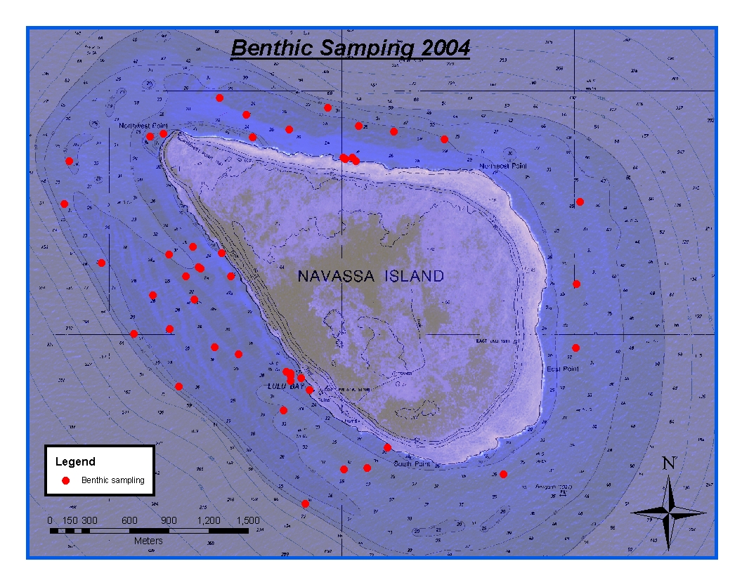
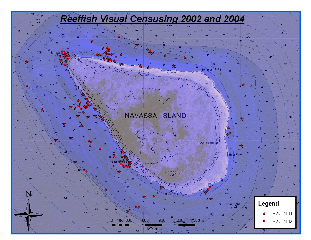
CRCP-Navassa reef assessment
National Oceanic and Atmospheric Administration, Department of Commerce —
Episodic cruises ( every 2 years) were conducted to perform assessments of Navassa Island coral reef resources including reeffish visual census, benthic reef... -
Federal
NOAA TIFF Image - 1m Multibeam Bathymetry, US Virgin Islands - Vieques Island (El Seco) - Project NF-09-01 - (2009), UTM 20N NAD83 (NCEI Accession 0131857)
National Oceanic and Atmospheric Administration, Department of Commerce —
This dataset contains a unified ESRI Grid with 1x1 meter cell size representing the bathymetry of El Seco, a selected portion of seafloor east of Vieques Island,...

Official websites use .gov
A
.gov website belongs to an official government
organization in the United States.
Secure .gov websites use HTTPS
A
lock (
) or https:// means you’ve safely connected to
the .gov website. Share sensitive information only on official,
secure websites.