
-
Federal
Shipping Fairways, Lanes, and Zones for US waters
National Oceanic and Atmospheric Administration, Department of Commerce —
Various shipping zones delineate activities and regulations for marine vessel traffic. Traffic lanes define specific traffic flow, while traffic separation zones... -
Federal
NOAA/WDS Paleoclimatology - The International Tree-Ring Data Bank (ITRDB) Revisited
National Oceanic and Atmospheric Administration, Department of Commerce —
This archived Paleoclimatology Study is available from the NOAA National Centers for Environmental Information (NCEI), under the World Data Service (WDS) for... -
Federal
Tropical Cyclone Wind Exposure
National Oceanic and Atmospheric Administration, Department of Commerce —
Hurricanes and other tropical cyclones pose a high risk to people, property, and ecosystems along the coastline of the United States. The impact of these storms can... -
Federal
NOAA/WDS Paleoclimatology - The Great Barrier Reef Coral Skeletal Records Database (GBRCD)
National Oceanic and Atmospheric Administration, Department of Commerce —
This archived Paleoclimatology Study is available from the NOAA National Centers for Environmental Information (NCEI), under the World Data Service (WDS) for... -
Federal
Sea Scallop Survey
National Oceanic and Atmospheric Administration, Department of Commerce —
The standardized NEFSC Sea Scallop Survey began in 1980 and has covered an area from Cape Hatteras to Georges Bank. The survey aims to determine the distribution and... -
Federal
Biologically Important Areas for Cetaceans within U.S. Waters 2015-03-01 - Present
National Oceanic and Atmospheric Administration, Department of Commerce —
The Cetacean Density and Distribution Mapping Working Group identified Biologically Important Areas (BIAs) for 24 cetacean species, stocks, or populations in seven... -
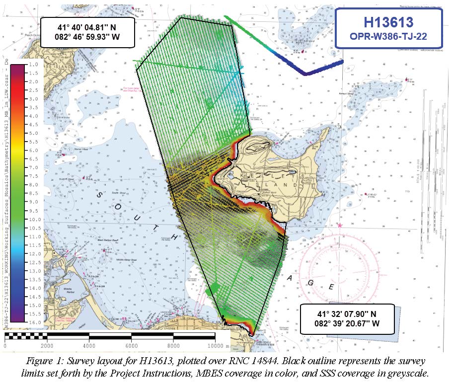
Federal
H13613: NOS Hydrographic Survey , 2022-06-15
National Oceanic and Atmospheric Administration, Department of Commerce —
The National Oceanic and Atmospheric Administration (NOAA) has the statutory mandate to collect hydrographic data in support of nautical chart compilation for safe... -
Federal
NOAA/WDS Paleoclimatology - Pregitzer, K.S., Gribben Forest (GRIBBEN) North American Plant Macrofossil Database
National Oceanic and Atmospheric Administration, Department of Commerce —
This archived Paleoclimatology Study is available from the NOAA National Centers for Environmental Information (NCEI), under the World Data Service (WDS) for... -
Federal
CRED Gridded 20m bathymetry and IKONOS estimated depths of Midway Atoll, Hawaii, USA (NetCDF Format)
National Oceanic and Atmospheric Administration, Department of Commerce —
Gridded bathymetry and IKONOS estimated depths of the shelf and slope environments of Midway Atoll, Hawaii, USA. Bottom coverage was achieved in depths between 0 and... -
Federal
COLREGS Demarcation Lines
National Oceanic and Atmospheric Administration, Department of Commerce —
U.S. collision regulation boundaries delineate those waters upon which mariners shall comply with the International Regulations for Preventing Collisions at Sea, 1972... -
Federal
Hawaii Hyperspectral Imagery 2000 (401-402-0620-332211) - Visual Interpretation from Remote Sensing Imagery Main Eight Hawaiian Islands
National Oceanic and Atmospheric Administration, Department of Commerce —
This project is a cooperative effort between the National Ocean Service, National Centers for Coastal Ocean Science, Center for Coastal Monitoring and Assessment, the... -
Federal
Hawaii Hyperspectral Imagery 2000 (420-0619-272217) - Visual Interpretation from Remote Sensing Imagery Main Eight Hawaiian Islands
National Oceanic and Atmospheric Administration, Department of Commerce —
This project is a cooperative effort between the National Ocean Service, National Centers for Coastal Ocean Science, Center for Coastal Monitoring and Assessment, the... -
Federal
Hillshades for the main 8 Hawaiian Islands
National Oceanic and Atmospheric Administration, Department of Commerce —
These hillshade datasets were derived from USGS 7.5' DEM Quads for the main 8 Hawaiian Islands. Individual DEM quads were first converted to a common datum, and... -
Federal
CRED 20m Gridded bathymetry of the banktop and slope environments of Northeast Bank (sometimes called "Muli" Seamount), American Samoa (NetCDF Format)
National Oceanic and Atmospheric Administration, Department of Commerce —
Gridded (20 m cell size) bathymetry of the banktop and slope environments of Northeast Bank (sometimes called "Muli" Seamount), American Samoa, South Pacific. Almost... -
Federal
Habitat Zone, Cover and Structure Maps of Tutuila 2001-2003, Derived from IKONOS Imagery
National Oceanic and Atmospheric Administration, Department of Commerce —
This project is a cooperative effort between the National Ocean Service, National Centers for Coastal Ocean Science, Center for Coastal Monitoring and Assessment, the... -
Federal
NOAA/WDS Paleoclimatology - Miller, N.G., Columbia Bridge (COLUMBIA) North American Plant Macrofossil Database
National Oceanic and Atmospheric Administration, Department of Commerce —
This archived Paleoclimatology Study is available from the NOAA National Centers for Environmental Information (NCEI), under the World Data Service (WDS) for... -
Federal
NOAA/WDS Paleoclimatology - Spear, R.W., Eagle Lake Bog (EAGLE) North American Plant Macrofossil Database
National Oceanic and Atmospheric Administration, Department of Commerce —
This archived Paleoclimatology Study is available from the NOAA National Centers for Environmental Information (NCEI), under the World Data Service (WDS) for... -
Federal
Archival and Discovery of March 28, 1964 Tsunami Event on Marigrams
National Oceanic and Atmospheric Administration, Department of Commerce —
NOAA National Centers for Environmental Information have more than 3,000 tsunami marigram (tide gauge) records in both image and paper format. The majority of these... -
Federal
Molokai Choice B IKONOS and Quickbird Imagery - Mosaic
National Oceanic and Atmospheric Administration, Department of Commerce —
This project is a cooperative effort between the National Ocean Service, National Centers for Coastal Ocean Science, Center for Coastal Monitoring and Assessment, BAE... -
Federal
Rugosity 20m grid derived from gridded bathymetry of Brooks Banks, Hawaii, USA
National Oceanic and Atmospheric Administration, Department of Commerce —
Rugosity is derived from gridded (20 m cell size) multibeam bathymetry, collected aboard NOAA ship Hi'ialakai and R/V AHI using the Benthic Terrain Modeler with...

Official websites use .gov
A
.gov website belongs to an official government
organization in the United States.
Secure .gov websites use HTTPS
A
lock (
) or https:// means you’ve safely connected to
the .gov website. Share sensitive information only on official,
secure websites.