
-
Federal
Coastal meteorological and water temperature data from the NOAA Center for Operational Oceanographic Products and Services (CO-OPS)
National Oceanic and Atmospheric Administration, Department of Commerce —
The NOAA Center for Operational Oceanographic Products and Services (CO-OPS) operates and maintains a network of long-term water level stations called the National... -
Federal
EMAG2: Earth Magnetic Anomaly Grid (2-arc-minute resolution)
National Oceanic and Atmospheric Administration, Department of Commerce —
EMAG2 is a global Earth Magnetic Anomaly Grid compiled from satellite, ship, and airborne magnetic measurements. It is a significant update of our previous candidate... -
Federal
Meteorological and oceanographic data collected from the National Data Buoy Center Coastal-Marine Automated Network (C-MAN) and moored (weather) buoys
National Oceanic and Atmospheric Administration, Department of Commerce —
The National Data Buoy Center (NDBC) established the Coastal-Marine Automated Network (C-MAN) for the National Weather Service in the early 1980's. NDBC has installed... -
Federal
MarineCadastre.gov
National Oceanic and Atmospheric Administration, Department of Commerce —
MarineCadastre.gov is a marine information system that provides authoritative ocean data, offshore planning tools, and technical support to the offshore renewable... -
Federal
NOAA ENC Direct to GIS
National Oceanic and Atmospheric Administration, Department of Commerce —
NOAA's Electronic Navigational Charts (NOAA ENCs) have been developed to support the marine transportation infrastructure and coastal management. The NOAA ENCs are in... -
Federal
Annual Penguin Census 1977-2015 v1.0
National Oceanic and Atmospheric Administration, Department of Commerce —
Data were collected from two penguin monitoring sites in the Antarctic peninsula region between 1977 and 2015 using traditional census methods. Seabirds observed in... -
Federal
RESTORE Sponsored Research Project: Protecting Texas coastlines from potential oil spills in Galveston Bay using drone surveys and maps of a new response effectiveness index
National Oceanic and Atmospheric Administration, Department of Commerce —
Galveston Bay and the surrounding Texas coast are vulnerable to marine oil spills, from both the high volume of marine commerce through the Galveston Bay ship channel... -
Federal
Physical and meteorological data from the Tropical Atmosphere Ocean (TAO) array in the tropical Pacific Ocean
National Oceanic and Atmospheric Administration, Department of Commerce —
The Tropical Atmosphere Ocean (TAO) Array of 55 moored buoys spans the tropical Pacific from longitudes 165°E to 95°W between latitudes of approximately 8°S and... -
Federal
Benthic Habitats of Puerto Rico and the U.S. Virgin Islands;Photomosaic of Puerto Rico (Luquillo), 1999
National Oceanic and Atmospheric Administration, Department of Commerce —
Habitat maps of Puerto Rico and the U.S. Virgin Islands were created by visual interpretation of aerial photographs using the Habitat Digitizer Extension. Aerial... -
Federal
NCCOS Long-term Monitoring Project: Regional Ecological Assessments and National Benthic Inventory
National Oceanic and Atmospheric Administration, Department of Commerce —
NOAA's National Centers for Coastal Ocean Science (NCCOS) works in partnership with other federal agencies and coastal states to conduct assessments of ecological... -
Federal
National Coral Reef Monitoring Program: Stratified Random Surveys (StRS) of Reef Fish, including Benthic Estimate Data of the Hawaiian Archipelago since 2013
National Oceanic and Atmospheric Administration, Department of Commerce —
The stationary point count (SPC) method is used to conduct reef fish surveys in the Hawaiian and Mariana Archipelagos, American Samoa, and the Pacific Remote Island... -
Federal
HMSRP Hawaiian Monk Seal Survey Data
National Oceanic and Atmospheric Administration, Department of Commerce —
This data set contains records of Hawaiian monk seal and green turtle sightings in the Northwestern Hawaiian Islands (NWHI) since 1982 at Lisianski Island, and since... -
Federal
National Coral Reef Monitoring Program: Assessment of coral reef fish communities in Puerto Rico
National Oceanic and Atmospheric Administration, Department of Commerce —
Data provided in this collection were gathered around Puerto Rico as part of NCCOS-led missions in collaboration with partners at U.S. Fish and Wildlife Service,... -
Federal
CO-OPS Air Gap Observations from Various Bridges within the United States and Its Territories
National Oceanic and Atmospheric Administration, Department of Commerce —
The Center for Operational Oceanographic Products and Services (CO-OPS) of the National Ocean Service (NOS), an organizational element of NOAA, operates and maintains... -
Federal
National Fish Habitat Action Plan (NFHAP) - Coastal Spatial Framework and Coastal Indicator Data
National Oceanic and Atmospheric Administration, Department of Commerce —
The NFHAP Coastal Spatial Framework and Indicator Datasets consist of a geospatial base layer developed in ArcGIS, and associated data fields joined to the spatial... -
Federal
H11195: NOS Hydrographic Survey , Southwest Alaska Peninsula, Alaska, 2003-06-06
National Oceanic and Atmospheric Administration, Department of Commerce —
The National Oceanic and Atmospheric Administration (NOAA) has the statutory mandate to collect hydrographic data in support of nautical chart compilation for safe... -
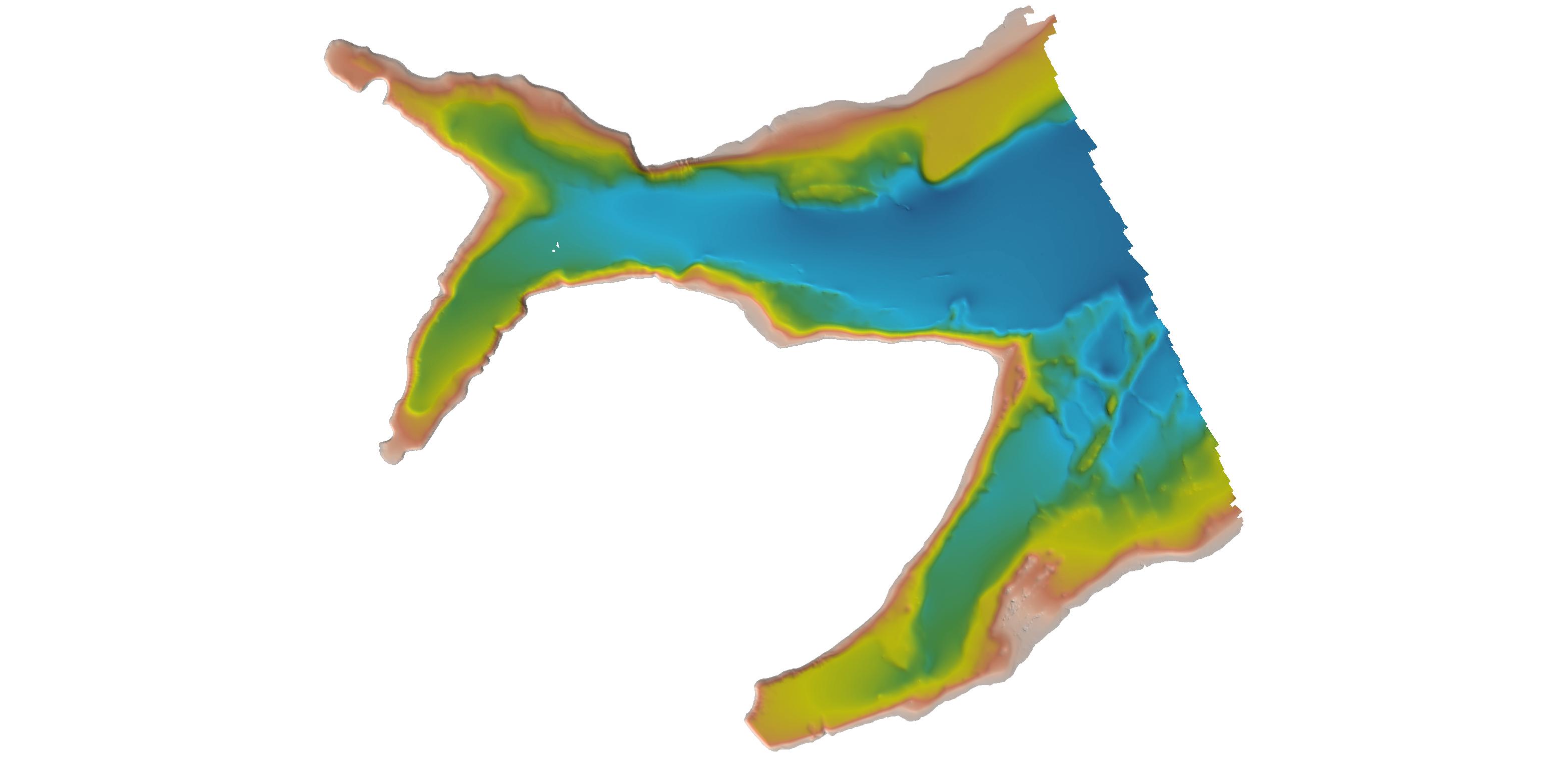
Federal
H12998: NOS Hydrographic Survey , 2017-06-30
National Oceanic and Atmospheric Administration, Department of Commerce —
The National Oceanic and Atmospheric Administration (NOAA) has the statutory mandate to collect hydrographic data in support of nautical chart compilation for safe... -
Federal
H13115: NOS Hydrographic Survey , 2018-07-21
National Oceanic and Atmospheric Administration, Department of Commerce —
The National Oceanic and Atmospheric Administration (NOAA) has the statutory mandate to collect hydrographic data in support of nautical chart compilation for safe... -
Federal
AFSC/NMML/CCEP: Diet of Pacific harbor seals at Umpqua River, Oregon and Columbia River, Oregon/Washington during 1994 through 2005
National Oceanic and Atmospheric Administration, Department of Commerce —
From 1994 to 2005, The National Marine Mammal Laboratories' California Current Ecosystem Program (AFSC/NOAA) collected fecal samples at the Umpqua River, Oregon and...

Official websites use .gov
A
.gov website belongs to an official government
organization in the United States.
Secure .gov websites use HTTPS
A
lock (
) or https:// means you’ve safely connected to
the .gov website. Share sensitive information only on official,
secure websites.
.jpg)