
-
Federal
Maritime Limits and Boundaries of United States of America NGDA
National Oceanic and Atmospheric Administration, Department of Commerce —
NOAA is responsible for depicting on its nautical charts the limits of the 12 nautical mile Territorial Sea, 24 nautical mile Contiguous Zone, and 200 nautical mile... -
Federal
H13773: NOS Hydrographic Survey , 2023-12-14
National Oceanic and Atmospheric Administration, Department of Commerce —
The National Oceanic and Atmospheric Administration (NOAA) has the statutory mandate to collect hydrographic data in support of nautical chart compilation for safe... -
Federal
Federal and State Waters
National Oceanic and Atmospheric Administration, Department of Commerce —
These data show the geographic representation of Federal and State Waters for the purpose of display in the MarineCadastre.gov OceanReports application. The boundary... -
Federal
Light Attenuation Kd490
National Oceanic and Atmospheric Administration, Department of Commerce —
This dataset represents monthly and annual mean summaries for Kd490 for the time period from 2000/2001 to 2017/2018, depending on the month and data available (see... -
Federal
Sea Scallop Survey
National Oceanic and Atmospheric Administration, Department of Commerce —
The standardized NEFSC Sea Scallop Survey began in 1980 and has covered an area from Cape Hatteras to Georges Bank. The survey aims to determine the distribution and... -
Federal
Archival and Discovery of November 4, 1952 Tsunami Event on Marigrams
National Oceanic and Atmospheric Administration, Department of Commerce —
NOAA National Centers for Environmental Information have more than 3,000 tsunami marigram (tide gauge) records in both image and paper format. The majority of these... -
Federal
Benthic Habitat Database
National Oceanic and Atmospheric Administration, Department of Commerce —
The NOAA Northeast Fisheries Science Center has, through the years, accumulated an extensive data base of qualitative and quantitative (wet weight and number per... -
Federal
Biologically Important Areas for Cetaceans within U.S. Waters 2015-03-01 - Present
National Oceanic and Atmospheric Administration, Department of Commerce —
The Cetacean Density and Distribution Mapping Working Group identified Biologically Important Areas (BIAs) for 24 cetacean species, stocks, or populations in seven... -
Federal
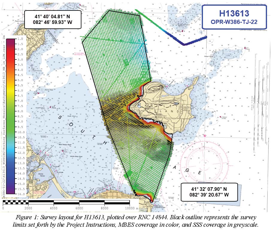
H13613: NOS Hydrographic Survey , 2022-06-15
National Oceanic and Atmospheric Administration, Department of Commerce —
The National Oceanic and Atmospheric Administration (NOAA) has the statutory mandate to collect hydrographic data in support of nautical chart compilation for safe... -
Federal
H13384: NOS Hydrographic Survey , 2021-03-10
National Oceanic and Atmospheric Administration, Department of Commerce —
The National Oceanic and Atmospheric Administration (NOAA) has the statutory mandate to collect hydrographic data in support of nautical chart compilation for safe... -
Federal
H13380: NOS Hydrographic Survey , 2020-08-12
National Oceanic and Atmospheric Administration, Department of Commerce —
The National Oceanic and Atmospheric Administration (NOAA) has the statutory mandate to collect hydrographic data in support of nautical chart compilation for safe... -
Federal
Summary of recreational hook and line caught sea turtles documented by the NOAA Galveston Laboratory
National Oceanic and Atmospheric Administration, Department of Commerce —
The database is a summary of sea turtles that are hook and line captured by recreational anglers in the region covered by the NOAA Galveston Laboratory through its... -
Federal
Landsat 7 ETM/1G satellite imagery - Hawaiian Islands cloud-free mosaics
National Oceanic and Atmospheric Administration, Department of Commerce —
Cloud-free Landsat satellite imagery mosaics of the islands of the main 8 Hawaiian Islands (Hawaii, Maui, Kahoolawe, Lanai, Molokai, Oahu, Kauai and Niihau). Landsat... -
Federal
Kelp distribution off California
National Oceanic and Atmospheric Administration, Department of Commerce —
This data set delineates kelp beds (Nereocystis leutkeana and Macrocystis spp.) along the Pacific Coast of California. Multiple years of kelp mapping data for the... -
Federal
Time-Series Data on the Ocean and Great Lakes Economy for Counties, States, and the Nation between 2005 and 2019 (Sector Level)
National Oceanic and Atmospheric Administration, Department of Commerce —
Economics: National Ocean Watch (ENOW) contains annual time-series data for over 400 coastal counties, 30 coastal states, 8 regions, and the nation, derived from the... -
Federal
Archival and Discovery of May 22, 1960 Tsunami Event on Marigrams
National Oceanic and Atmospheric Administration, Department of Commerce —
NOAA National Centers for Environmental Information have more than 3,000 tsunami marigram (tide gauge) records in both image and paper format. The majority of these... -
Federal
AIS Vessel Tracks 2016
National Oceanic and Atmospheric Administration, Department of Commerce —
Vessels traveling in U.S. coastal and inland waters frequently use Automatic Identification Systems (AIS) for navigation safety. The U.S. Coast Guard collects AIS... -
Federal
H13761: NOS Hydrographic Survey , 2023-10-25
National Oceanic and Atmospheric Administration, Department of Commerce —
The National Oceanic and Atmospheric Administration (NOAA) has the statutory mandate to collect hydrographic data in support of nautical chart compilation for safe...

Official websites use .gov
A
.gov website belongs to an official government
organization in the United States.
Secure .gov websites use HTTPS
A
lock (
) or https:// means you’ve safely connected to
the .gov website. Share sensitive information only on official,
secure websites.