
-
Federal
EMAG2: Earth Magnetic Anomaly Grid (2-arc-minute resolution)
National Oceanic and Atmospheric Administration, Department of Commerce —
EMAG2 is a global Earth Magnetic Anomaly Grid compiled from satellite, ship, and airborne magnetic measurements. It is a significant update of our previous candidate... -
Federal
H11370: NOS Hydrographic Survey , Budd Inlet, Washington, 2005-08-22
National Oceanic and Atmospheric Administration, Department of Commerce —
The National Oceanic and Atmospheric Administration (NOAA) has the statutory mandate to collect hydrographic data in support of nautical chart compilation for safe... -
Federal
42012 - Orange Beach AL Buoy
National Oceanic and Atmospheric Administration, Department of Commerce —
GCOOS 52North Sensor Observation Service This station provides the following variables: Air pressure, Air temperature, Sea water temperature, Wind speed, Wind speed... -
Federal
CRED SVP Drifting Buoy Argos_ID 29103 Data, Pathfinder Reef in the Marianas Archipelago, 200309-200406 (NODC Accession 0067473)
National Oceanic and Atmospheric Administration, Department of Commerce —
CRED SVP drifter Argos_ID 29103 was deployed in the region of Marianas Archipelago to assess ocean currents and sea surface temperature. SVP drifter data files... -
Federal
H10555: NOS Hydrographic Survey , Port Angeles, Washington, 1994-11-21
National Oceanic and Atmospheric Administration, Department of Commerce —
The National Oceanic and Atmospheric Administration (NOAA) has the statutory mandate to collect hydrographic data in support of nautical chart compilation for safe... -
Federal
CRED SVP Drifting Buoy Argos_ID 30340 Data Kauai Channel, Main Hawaiian Islands, 200210-200409 (NODC Accession 0049436)
National Oceanic and Atmospheric Administration, Department of Commerce —
CRED SVP drifter Argos_ID 30340 was deployed in the region of Main Hawaiian Islands to assess ocean currents and sea surface temperature. SVP drifter data files... -
Federal
Bayou La Batre Bridge, AL
National Oceanic and Atmospheric Administration, Department of Commerce —
GCOOS 52North Sensor Observation Service This station provides the following variables: Sea surface height above sea level -
Federal
CRED Cumulative Map of Percent Scleractinian Coral Cover at Maug
National Oceanic and Atmospheric Administration, Department of Commerce —
This map displays optical validation observation locations and percent coverage of scleractinian coral overlaid on bathymetry. -
Federal
H11086: NOS Hydrographic Survey , Olympic Coast National Marine Sanctuary, Washington, 2001-10-24
National Oceanic and Atmospheric Administration, Department of Commerce —
The National Oceanic and Atmospheric Administration (NOAA) has the statutory mandate to collect hydrographic data in support of nautical chart compilation for safe... -
Federal
Dauphin Island, AL
National Oceanic and Atmospheric Administration, Department of Commerce —
GCOOS 52North Sensor Observation Service This station provides the following variables: Air pressure, Air temperature, Sea surface height above sea level, Wind speed,... -
Federal
H03011A: NOS Hydrographic Survey , 1910-12-31
National Oceanic and Atmospheric Administration, Department of Commerce —
The National Oceanic and Atmospheric Administration (NOAA) has the statutory mandate to collect hydrographic data in support of nautical chart compilation for safe... -
Federal
H11649: NOS Hydrographic Survey , Mid-Atlantic Corridor, Maryland, 2007-11-18
National Oceanic and Atmospheric Administration, Department of Commerce —
The National Oceanic and Atmospheric Administration (NOAA) has the statutory mandate to collect hydrographic data in support of nautical chart compilation for safe... -
Federal
H12310: NOS Hydrographic Survey , Southern Puget Sound, Washington, 2011-10-14
National Oceanic and Atmospheric Administration, Department of Commerce —
The National Oceanic and Atmospheric Administration (NOAA) has the statutory mandate to collect hydrographic data in support of nautical chart compilation for safe... -
Federal
F00411: NOS Hydrographic Survey , One Mile South of Nashawena Island, Massachusetts, 1995-03-22
National Oceanic and Atmospheric Administration, Department of Commerce —
The National Oceanic and Atmospheric Administration (NOAA) has the statutory mandate to collect hydrographic data in support of nautical chart compilation for safe... -
Federal
H10665: NOS Hydrographic Survey , Southern Puget Sound, Washington, 1996-04-25
National Oceanic and Atmospheric Administration, Department of Commerce —
The National Oceanic and Atmospheric Administration (NOAA) has the statutory mandate to collect hydrographic data in support of nautical chart compilation for safe... -
Federal
42003 - E GULF 262 nm South of Panama City, FL
National Oceanic and Atmospheric Administration, Department of Commerce —
GCOOS 52North Sensor Observation Service This station provides the following variables: Air pressure, Air temperature, Direction of sea water velocity, Sea water... -
Federal
Mobile State Docks, AL
National Oceanic and Atmospheric Administration, Department of Commerce —
GCOOS 52North Sensor Observation Service This station provides the following variables: Air pressure, Air temperature, Sea surface height above sea level, Sea water... -
Federal
F00364: NOS Hydrographic Survey , Southern New England Coast, Connecticut and New York, 1991-09-18
National Oceanic and Atmospheric Administration, Department of Commerce —
The National Oceanic and Atmospheric Administration (NOAA) has the statutory mandate to collect hydrographic data in support of nautical chart compilation for safe... -
Federal
F00389: NOS Hydrographic Survey , Solomons Island Naval Annex Pier, Maryland, 1993-07-20
National Oceanic and Atmospheric Administration, Department of Commerce —
The National Oceanic and Atmospheric Administration (NOAA) has the statutory mandate to collect hydrographic data in support of nautical chart compilation for safe... -
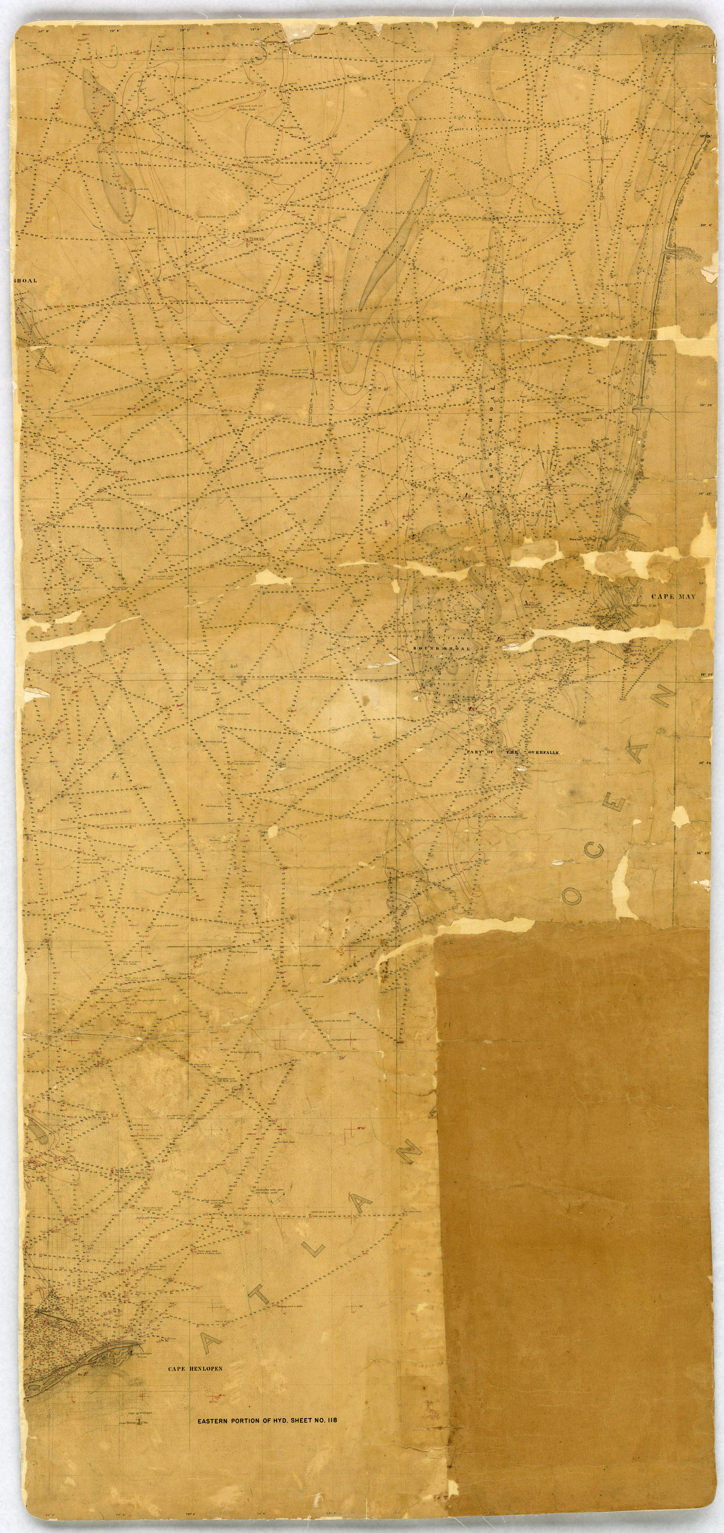
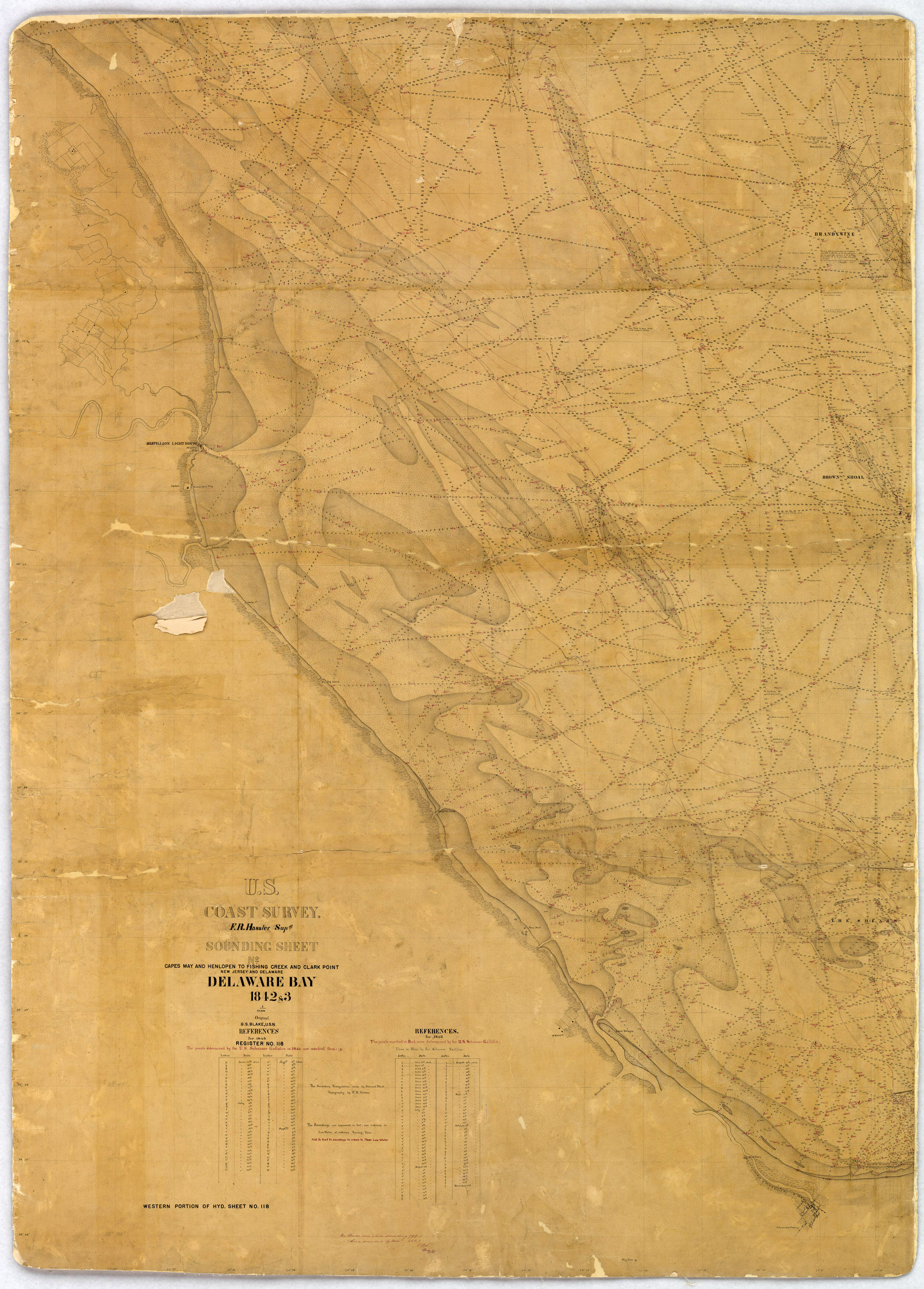
Federal
H00118: NOS Hydrographic Survey , 1843-12-31
National Oceanic and Atmospheric Administration, Department of Commerce —
The National Oceanic and Atmospheric Administration (NOAA) has the statutory mandate to collect hydrographic data in support of nautical chart compilation for safe...

Official websites use .gov
A
.gov website belongs to an official government
organization in the United States.
Secure .gov websites use HTTPS
A
lock (
) or https:// means you’ve safely connected to
the .gov website. Share sensitive information only on official,
secure websites.
.jpg)
.jpg)
.jpg)
.jpg)
.jpg)
.jpg)
.jpg)