
-
Federal
Gulf of Mexico Hypoxia Watch Bottom Dissolved Oxygen Contours for June and July SEAMAP Cruise of 2005
National Oceanic and Atmospheric Administration, Department of Commerce —
The NOAA Hypoxia Watch project provides near-real-time, web-based maps of dissolved oxygen near the sea floor over the Texas-Louisiana continental shelf during a... -
Federal
Shipping Fairways, Lanes, and Zones for US waters
National Oceanic and Atmospheric Administration, Department of Commerce —
Various shipping zones delineate activities and regulations for marine vessel traffic. Traffic lanes define specific traffic flow, while traffic separation zones... -
Federal
Tropical Cyclone Storm Segments
National Oceanic and Atmospheric Administration, Department of Commerce —
The patterns and variability of hurricane tracks are an important indicator for scientists and emergency managers to assess risk and build resilience among coastal... -
Federal
H13773: NOS Hydrographic Survey , 2023-12-14
National Oceanic and Atmospheric Administration, Department of Commerce —
The National Oceanic and Atmospheric Administration (NOAA) has the statutory mandate to collect hydrographic data in support of nautical chart compilation for safe... -
Federal
Congressional Districts
National Oceanic and Atmospheric Administration, Department of Commerce —
These data depict the 117th Congressional Districts and their representatives for the United States. Congressional districts are the 435 areas from which members are... -
Federal
Side-Scan-Sonar Lines for Hudson River, NY
National Oceanic and Atmospheric Administration, Department of Commerce —
Side Scan Sonar and Subbottom Profiler Tracklines. Data was collected November 5 to December 15, 2009, in the estuary north from Saugerties to Troy. Fugro utilized... -
Federal
Federal and State Waters
National Oceanic and Atmospheric Administration, Department of Commerce —
These data show the geographic representation of Federal and State Waters for the purpose of display in the MarineCadastre.gov OceanReports application. The boundary... -
Federal
Time-Series Data on the Ocean and Great Lakes Economy for Counties, States, and the Nation between 2005 and 2019 (Sector Level)
National Oceanic and Atmospheric Administration, Department of Commerce —
Economics: National Ocean Watch (ENOW) contains annual time-series data for over 400 coastal counties, 30 coastal states, 8 regions, and the nation, derived from the... -
Federal
Atlantic Surfclam and Ocean Quahog Survey
National Oceanic and Atmospheric Administration, Department of Commerce —
The standardized NEFSC Atlantic Surfclam and Ocean Quahog Survey has covered an area from Cape Hatteras to Georges Bank. The survey was conducted every two or three... -
Federal
Marine Protected Areas (MPA) Inventory 2023-2024 NGDA
National Oceanic and Atmospheric Administration, Department of Commerce —
The NOAA MPA Inventory represents a collection of data compiled from various federal, state, tribal and territorial entities to provide a publicly available source of... -
Federal
2005 Hypoxia Watch Bottom CTD Station Locations
National Oceanic and Atmospheric Administration, Department of Commerce —
The NOAA Hypoxia Watch project provides near-real-time, web-based maps of dissolved oxygen near the sea floor over the Texas-Louisiana continental shelf during a... -
Federal
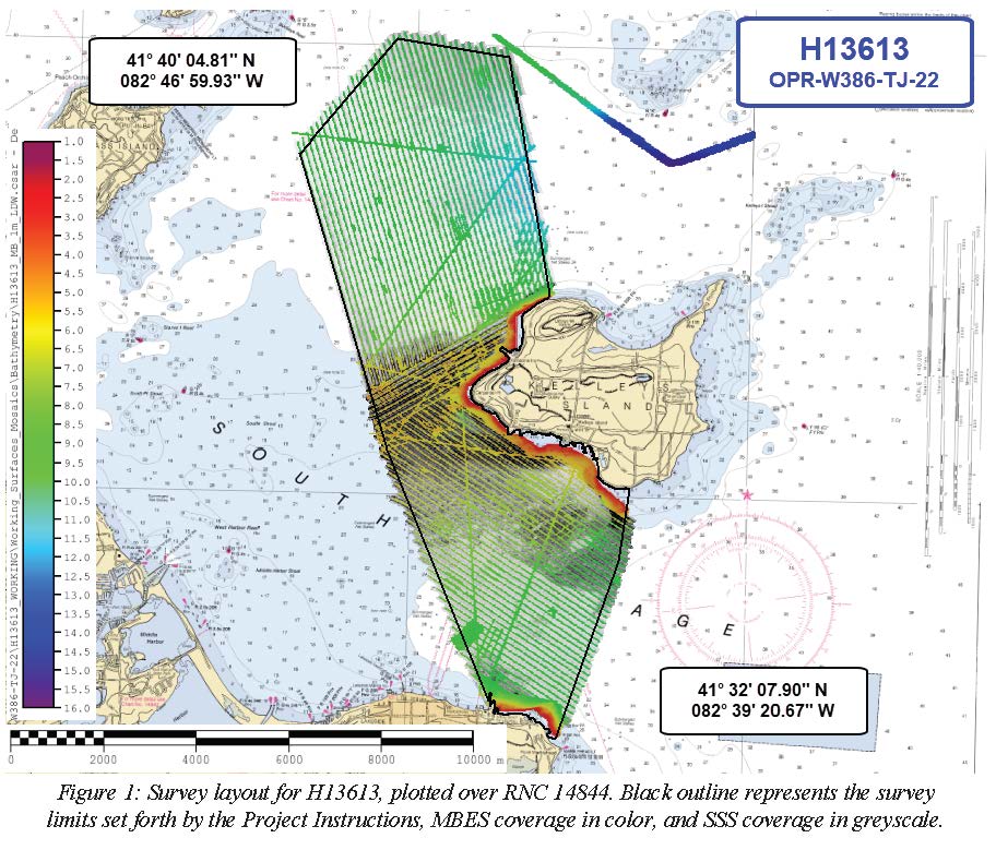
H13613: NOS Hydrographic Survey , 2022-06-15
National Oceanic and Atmospheric Administration, Department of Commerce —
The National Oceanic and Atmospheric Administration (NOAA) has the statutory mandate to collect hydrographic data in support of nautical chart compilation for safe... -
Federal
NOAA/WDS Paleoclimatology - Givens, C.R., Little Bayou Sara 4 (LBSARA4J) North American Plant Macrofossil Database
National Oceanic and Atmospheric Administration, Department of Commerce —
This archived Paleoclimatology Study is available from the NOAA National Centers for Environmental Information (NCEI), under the World Data Service (WDS) for...

Official websites use .gov
A
.gov website belongs to an official government
organization in the United States.
Secure .gov websites use HTTPS
A
lock (
) or https:// means you’ve safely connected to
the .gov website. Share sensitive information only on official,
secure websites.