
-
Federal
NOAA NWS Historical Hydrology Data, Air Temperature, AORC ABRFC (Oklahoma), 1979 [EXPERIMENTAL DEMONSTRATION], Lon0360
National Oceanic and Atmospheric Administration, Department of Commerce —
NOAA National Weather Service (NWS) Historical Hydrology, Analysis of Record for Calibration (AORC), air temperature data for the AORC ABRFC (Oklahoma) region, using... -
Federal
Meteorological and oceanographic data collected from the National Data Buoy Center Coastal-Marine Automated Network (C-MAN) and moored (weather) buoys
National Oceanic and Atmospheric Administration, Department of Commerce —
The National Data Buoy Center (NDBC) established the Coastal-Marine Automated Network (C-MAN) for the National Weather Service in the early 1980's. NDBC has installed... -
Federal
NOAA GOES-R Series Advanced Baseline Imager (ABI) Level 2 Cloud and Moisture Imagery Products (CMIP)
National Oceanic and Atmospheric Administration, Department of Commerce —
The Cloud and Moisture Imagery product contains one or more Earth-view images with pixel values identifying brightness values that are scaled to support visual... -
Federal
NOAA Coral Reef Watch (CRW) Daily Global 5-km (0.05 degree) Satellite Coral Bleaching Heat Stress Monitoring Product Suite
National Oceanic and Atmospheric Administration, Department of Commerce —
The NOAA Coral Reef Watch (CRW) daily global 5-km (0.05 degree) satellite coral bleaching heat stress monitoring product suite (currently Version 3.1, released August... -
Federal
NOAA GOES-R Series Advanced Baseline Imager (ABI) Level 1b Radiances
National Oceanic and Atmospheric Administration, Department of Commerce —
The Advanced Baseline Imager (ABI) operates on board the NOAA Geostationary Operational Environmental Satellite-R (GOES-R) Series weather satellites providing... -
Federal
Geostationary Operational Environmental Satellite, R-Series (GOES-R) Space Environment In-Situ Suite (SEISS) Level 2 Products
National Oceanic and Atmospheric Administration, Department of Commerce —
The Space Environment In-Situ Suite (SEISS) is comprised of four sensors that monitor proton, electron, and heavy ion fluxes in the magnetosphere. These four sensors... -
Federal
Marine Mammals and Sea Turtles data for the Deepwater Horizon Response and Assessment in the Gulf of Mexico, dating from 2001-06-19 to 2016-02-16
National Oceanic and Atmospheric Administration, Department of Commerce —
These Marine Mammals and Sea Turtles data were gathered and utilized during the Response and Assessment phases of the Deepwater Horizon oil spill in the Gulf of... -
Federal
Right Whale Sightings Advisory System (RWSAS)
National Oceanic and Atmospheric Administration, Department of Commerce —
The Right Whale Sighting Advisory System (RWSAS) is a NOAA Fisheries program which was designed to reduce collisions between ships and the critically endangered North... -
Federal
NOAA Marine Debris Clearinghouse Program data on debris surveys and removal projects from 2005 to 2019 (NCEI Accession 0190414)
National Oceanic and Atmospheric Administration, Department of Commerce —
This data set contains information on historical marine debris survey and removal projects of the NOAA Marine Debris Program and its many funded partners. This data... -
Federal
National Coral Reef Monitoring Program: Stratified Random Surveys (StRS) of Coral Demography (Adult and Juvenile Corals) across the Pacific Remote Island Areas from 2014 to 2018
National Oceanic and Atmospheric Administration, Department of Commerce —
NCRMP CORAL DEMOGRAPHIC DATA HAS NOW BEEN MERGED INTO A PACIFIC-WIDE METADATA RECORD -- PLEASE REFER TO https://www.fisheries.noaa.gov/inport/item/71550 FOR MOST... -
Federal
Surface ocean radial velocities obtained by HF-radar from stations located along coastal waters of Hawaii, North Slope Alaska, Gulf of Alaska, Puerto Rico/Virgin Islands, eastern U.S./Gulf of America, western U.S., and the Great Lakes
National Oceanic and Atmospheric Administration, Department of Commerce —
This dataset contains surface ocean radial velocities data obtained by HF-radar from stations located along coastal waters of the United States. Radial velocity files... -
Federal
NOAA/WDS Paleoclimatology - Veblen fire data from BM39 - IMPD USBM-039
National Oceanic and Atmospheric Administration, Department of Commerce —
This archived Paleoclimatology Study is available from the NOAA National Centers for Environmental Information (NCEI), under the World Data Service (WDS) for... -
Federal
H06264: NOS Hydrographic Survey , 1937-12-31
National Oceanic and Atmospheric Administration, Department of Commerce —
The National Oceanic and Atmospheric Administration (NOAA) has the statutory mandate to collect hydrographic data in support of nautical chart compilation for safe... -
Federal
Physical and meteorological data from the Tropical Atmosphere Ocean (TAO) array in the tropical Pacific Ocean
National Oceanic and Atmospheric Administration, Department of Commerce —
The Tropical Atmosphere Ocean (TAO) Array of 55 moored buoys spans the tropical Pacific from longitudes 165°E to 95°W between latitudes of approximately 8°S and... -
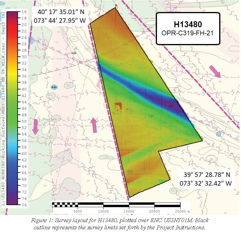
Federal
H13480: NOS Hydrographic Survey , 2021-10-07
National Oceanic and Atmospheric Administration, Department of Commerce —
The National Oceanic and Atmospheric Administration (NOAA) has the statutory mandate to collect hydrographic data in support of nautical chart compilation for safe... -
Federal
AFSC/RACE/GAP/Prescott: Norton Sound Shoreline
National Oceanic and Atmospheric Administration, Department of Commerce —
We assembled approximately 230,000 National Ocean Service (NOS) bathymetric soundings from 39 lead-line and single-beam echosounder hydrographic surveys conducted... -
Federal
H06140: NOS Hydrographic Survey , 1936-12-31
National Oceanic and Atmospheric Administration, Department of Commerce —
The National Oceanic and Atmospheric Administration (NOAA) has the statutory mandate to collect hydrographic data in support of nautical chart compilation for safe... -
Federal
Near-real-time surface ocean velocities derived from HF-radar stations located along coastal waters of North Slope Alaska, Gulf of Alaska, Puerto Rico/Virgin Islands, eastern U.S./Gulf of America, Hawaii, Great Lakes, and western U.S.
National Oceanic and Atmospheric Administration, Department of Commerce —
This dataset contains near-real-time ocean surface velocities, also known as total vector velocities, derived from high-frequency (HF) radar stations. The velocities... -
Federal
H06217: NOS Hydrographic Survey , 1937-12-31
National Oceanic and Atmospheric Administration, Department of Commerce —
The National Oceanic and Atmospheric Administration (NOAA) has the statutory mandate to collect hydrographic data in support of nautical chart compilation for safe...

Official websites use .gov
A
.gov website belongs to an official government
organization in the United States.
Secure .gov websites use HTTPS
A
lock (
) or https:// means you’ve safely connected to
the .gov website. Share sensitive information only on official,
secure websites.