
-
Federal
Food Habits Database (FHDBS)
National Oceanic and Atmospheric Administration, Department of Commerce —
The NEFSC Food Habits Database has two major sources of data. The first, and most extensive, is the standard NEFSC Bottom Trawl Surveys Program. During these surveys,... -
Federal
Sea Scallop Survey
National Oceanic and Atmospheric Administration, Department of Commerce —
The standardized NEFSC Sea Scallop Survey began in 1980 and has covered an area from Cape Hatteras to Georges Bank. The survey aims to determine the distribution and... -
Federal
Tissue Tracking System
National Oceanic and Atmospheric Administration, Department of Commerce —
NEFSC holds a sample inventory of marine mammal parts collected from stranded and bycaught animals as well as from our field research activities. The database holds... -
Federal
H13761: NOS Hydrographic Survey , 2023-10-25
National Oceanic and Atmospheric Administration, Department of Commerce —
The National Oceanic and Atmospheric Administration (NOAA) has the statutory mandate to collect hydrographic data in support of nautical chart compilation for safe... -
Federal
H11760: NOS Hydrographic Survey , Endicott Arm, Alaska, 2007-11-01
National Oceanic and Atmospheric Administration, Department of Commerce —
The National Oceanic and Atmospheric Administration (NOAA) has the statutory mandate to collect hydrographic data in support of nautical chart compilation for safe... -
Federal
Winter Bottom Trawl Survey
National Oceanic and Atmospheric Administration, Department of Commerce —
The standardized NEFSC Winter Bottom Trawl Survey was initiated in 1992 and covered offshore areas from the Mid-Atlantic to Georges Bank. Inshore strata were covered... -
Federal
H11587: NOS Hydrographic Survey , Southwest Alaska Peninsula, Alaska, 2006-08-30
National Oceanic and Atmospheric Administration, Department of Commerce —
The National Oceanic and Atmospheric Administration (NOAA) has the statutory mandate to collect hydrographic data in support of nautical chart compilation for safe... -
Federal
Benthic grab data from October 1999 in Apalachicola Bay, Florida
National Oceanic and Atmospheric Administration, Department of Commerce —
The Apalachicola Bay National Estuarine Research Reserve and the NOAA Office for Coastal Management worked together to map benthic habitats within Apalachicola Bay,... -
Federal
Benthic Habitats of Guam Derived From IKONOS Imagery, 2001-2003
National Oceanic and Atmospheric Administration, Department of Commerce —
This project is a cooperative effort among the National Ocean Service, National Centers for Coastal Ocean Science, Center for Coastal Monitoring and Assessment; the... -
Federal
Benthic Habitats of Puerto Rico and the U.S. Virgin Islands; Photomosaic of Puerto Rico (Cabo Rojo), 1999
National Oceanic and Atmospheric Administration, Department of Commerce —
Habitat maps of Puerto Rico and the U.S. Virgin Islands were created by visual interpretation of aerial photographs using the Habitat Digitizer Extension. Aerial... -
Federal
NOAA/WDS Paleoclimatology - Payette, S., Lac des Indiens, Site 3 (LACIND3C) North American Plant Macrofossil Database
National Oceanic and Atmospheric Administration, Department of Commerce —
This archived Paleoclimatology Study is available from the NOAA National Centers for Environmental Information (NCEI), under the World Data Service (WDS) for... -
Federal
NOAA/WDS Paleoclimatology - Payette, S., Riviere Emerillon, Site 11 (RIVEM11C) North American Plant Macrofossil Database
National Oceanic and Atmospheric Administration, Department of Commerce —
This archived Paleoclimatology Study is available from the NOAA National Centers for Environmental Information (NCEI), under the World Data Service (WDS) for... -
Federal
Deep Water Survey Data
National Oceanic and Atmospheric Administration, Department of Commerce —
The deep water biodiversity surveys explore and describe the biodiversity of the bathy- and bentho-pelagic nekton using Midwater and bottom trawls. The covered area... -
Federal
Slope Grid Derived from Gridded Bathymetry for Select U.S. Coral Reef Locations across the Pacific Ocean
National Oceanic and Atmospheric Administration, Department of Commerce —
Slope is derived for islands and banks across the U.S. Pacific Islands Region primarily from gridded multibeam bathymetry collected aboard NOAA Ships Hi'ialakai and... -
Federal
Archival and Discovery of April 1, 1946 Tsunami Event on Marigrams
National Oceanic and Atmospheric Administration, Department of Commerce —
NOAA National Centers for Environmental Information have more than 3,000 tsunami marigram (tide gauge) records in both image and paper format. The majority of these... -
Federal
Habitat Zone, Cover and Structure Maps of Guam 2001-2003, Derived From IKONOS Imagery
National Oceanic and Atmospheric Administration, Department of Commerce —
This project is a cooperative effort between the National Ocean Service, National Centers for Coastal Ocean Science, Center for Coastal Monitoring and Assessment, the... -
Federal
Atlantic Surfclam and Ocean Quahog Survey
National Oceanic and Atmospheric Administration, Department of Commerce —
The standardized NEFSC Atlantic Surfclam and Ocean Quahog Survey has covered an area from Cape Hatteras to Georges Bank. The survey was conducted every two or three... -
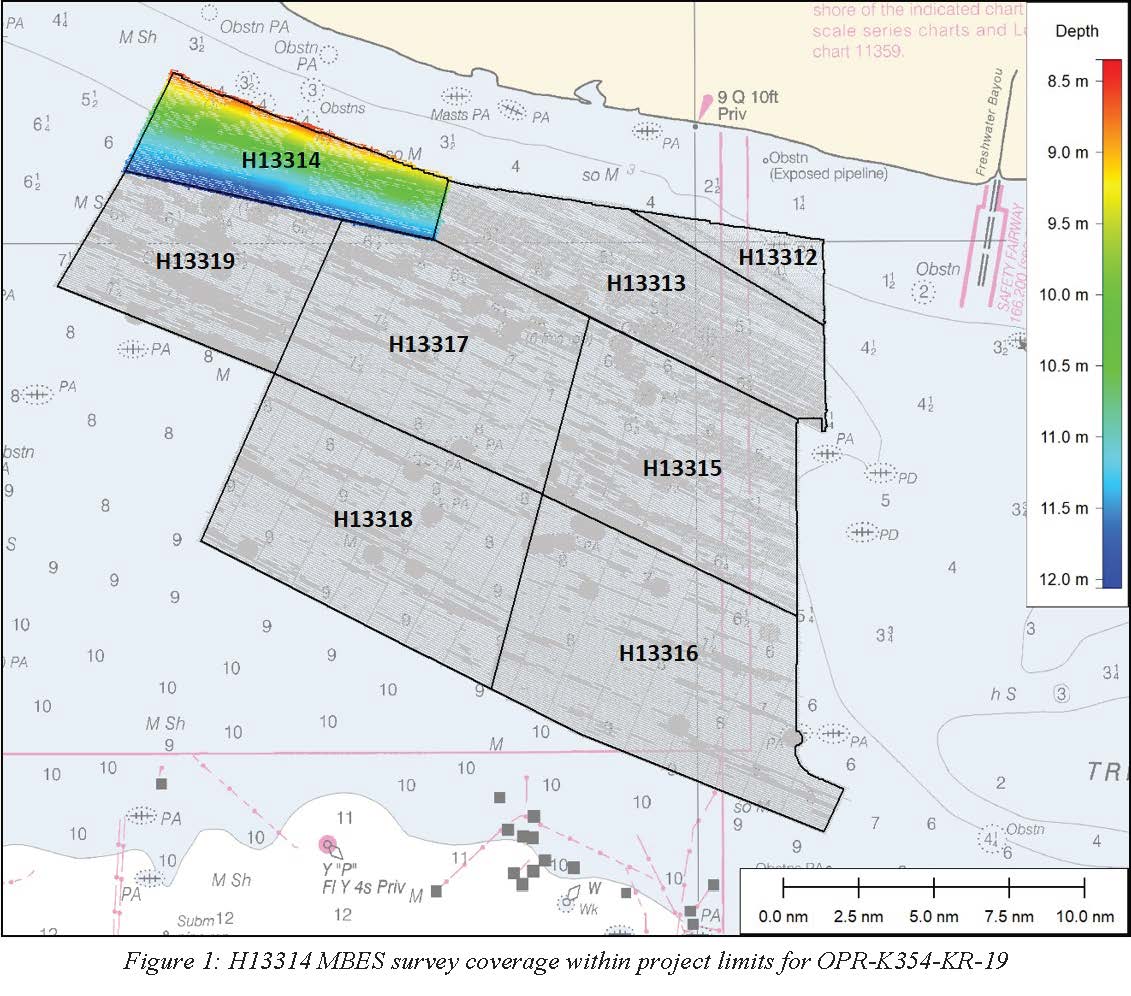
Federal
H13314: NOS Hydrographic Survey , 2020-02-22
National Oceanic and Atmospheric Administration, Department of Commerce —
The National Oceanic and Atmospheric Administration (NOAA) has the statutory mandate to collect hydrographic data in support of nautical chart compilation for safe... -
Federal
AFSC/FMA/North Pacific Observer Debriefed Data Presentation Layer (OBSINT)
National Oceanic and Atmospheric Administration, Department of Commerce —
Observer data span more than two decades and multiple database development interations. To facilitate status of stocks authors and other users of these records, a... -
Federal
Fish assemblages in southern California using trawl data from the National Marine Fisheries Service
National Oceanic and Atmospheric Administration, Department of Commerce —
Fish benthic trawls were completed by the National Marine Fisheries Service Groundfish Survey Program (NMFS GSP). Data from 477 fishery independent trawls ranging...

Official websites use .gov
A
.gov website belongs to an official government
organization in the United States.
Secure .gov websites use HTTPS
A
lock (
) or https:// means you’ve safely connected to
the .gov website. Share sensitive information only on official,
secure websites.