
-
Federal
Kelp distribution off California
National Oceanic and Atmospheric Administration, Department of Commerce —
This data set delineates kelp beds (Nereocystis leutkeana and Macrocystis spp.) along the Pacific Coast of California. Multiple years of kelp mapping data for the... -
Federal
Gulf of Mexico Hypoxia Watch Bottom Dissolved Oxygen Contours for June and July SEAMAP Cruise of 2005
National Oceanic and Atmospheric Administration, Department of Commerce —
The NOAA Hypoxia Watch project provides near-real-time, web-based maps of dissolved oxygen near the sea floor over the Texas-Louisiana continental shelf during a... -
Federal
Delaware River and Upper Bay Sediment Data
National Oceanic and Atmospheric Administration, Department of Commerce —
The area of coverage consists of 192 square miles of benthic habitat mapped from 2005 to 2007 in the Delaware River and Upper Delaware Bay. The bottom sediment map... -
Federal
2005 Hypoxia Watch Bottom CTD Station Locations
National Oceanic and Atmospheric Administration, Department of Commerce —
The NOAA Hypoxia Watch project provides near-real-time, web-based maps of dissolved oxygen near the sea floor over the Texas-Louisiana continental shelf during a... -
Federal
2003 Hypoxia Watch Bottom CTD Station Locations
National Oceanic and Atmospheric Administration, Department of Commerce —
The NOAA Hypoxia Watch project provides near-real-time, web-based maps of dissolved oxygen near the sea floor over the Texas-Louisiana continental shelf during a... -
Federal
Benthic Habitats of Puerto Rico and the U.S. Virgin Islands;Photomosaic of Puerto Rico (Rincon), 1999
National Oceanic and Atmospheric Administration, Department of Commerce —
Habitat maps of Puerto Rico and the U.S. Virgin Islands were created by visual interpretation of aerial photographs using the Habitat Digitizer Extension. Aerial... -
Federal
COLREGS Demarcation Lines
National Oceanic and Atmospheric Administration, Department of Commerce —
U.S. collision regulation boundaries delineate those waters upon which mariners shall comply with the International Regulations for Preventing Collisions at Sea, 1972... -
Federal
Gulf of Mexico Hypoxia Watch Bottom Dissolved Oxygen Contours for June and July SEAMAP Cruise of 2008
National Oceanic and Atmospheric Administration, Department of Commerce —
The NOAA Hypoxia Watch project provides near-real-time, web-based maps of dissolved oxygen near the sea floor over the Texas-Louisiana continental shelf during a... -
Federal
H13973: NOS Hydrographic Survey , 2025-01-25
National Oceanic and Atmospheric Administration, Department of Commerce —
The National Oceanic and Atmospheric Administration (NOAA) has the statutory mandate to collect hydrographic data in support of nautical chart compilation for safe... -
Federal
Atlantic Surfclam and Ocean Quahog Survey
National Oceanic and Atmospheric Administration, Department of Commerce —
The standardized NEFSC Atlantic Surfclam and Ocean Quahog Survey has covered an area from Cape Hatteras to Georges Bank. The survey was conducted every two or three... -
Federal
Benthic Habitats of Puerto Rico and the U.S. Virgin Islands;Photomosaic of Puerto Rico (San Juan), 1999
National Oceanic and Atmospheric Administration, Department of Commerce —
Habitat maps of Puerto Rico and the U.S. Virgin Islands were created by visual interpretation of aerial photographs using the Habitat Digitizer Extension. Aerial... -
Federal
NOAA Point Shapefile - ROV transects, US Caribbean - St. Thomas and St. John - Project NF-03-10-USVI - (2010), UTM 20N NAD83
National Oceanic and Atmospheric Administration, Department of Commerce —
This shapefile denotes the location of underwater photos and/or video that were collected by NOAA scientists using a Spectrum Phantom S2 ROV (remotely operated... -
Federal
Benthic Habitats of Puerto Rico and the U.S. Virgin Islands;Photomosaic of Puerto Rico (Barcelon), 1999
National Oceanic and Atmospheric Administration, Department of Commerce —
Habitat maps of Puerto Rico and the U.S. Virgin Islands were created by visual interpretation of aerial photographs using the Habitat Digitizer Extension. Aerial... -
Federal
Red Porgy Reproductive Analysis
National Oceanic and Atmospheric Administration, Department of Commerce —
Protogynous fishes are often assumed to be more sensitive than gonochorists to exploitation, primarily because of potential sperm limitation and/or social disruption... -
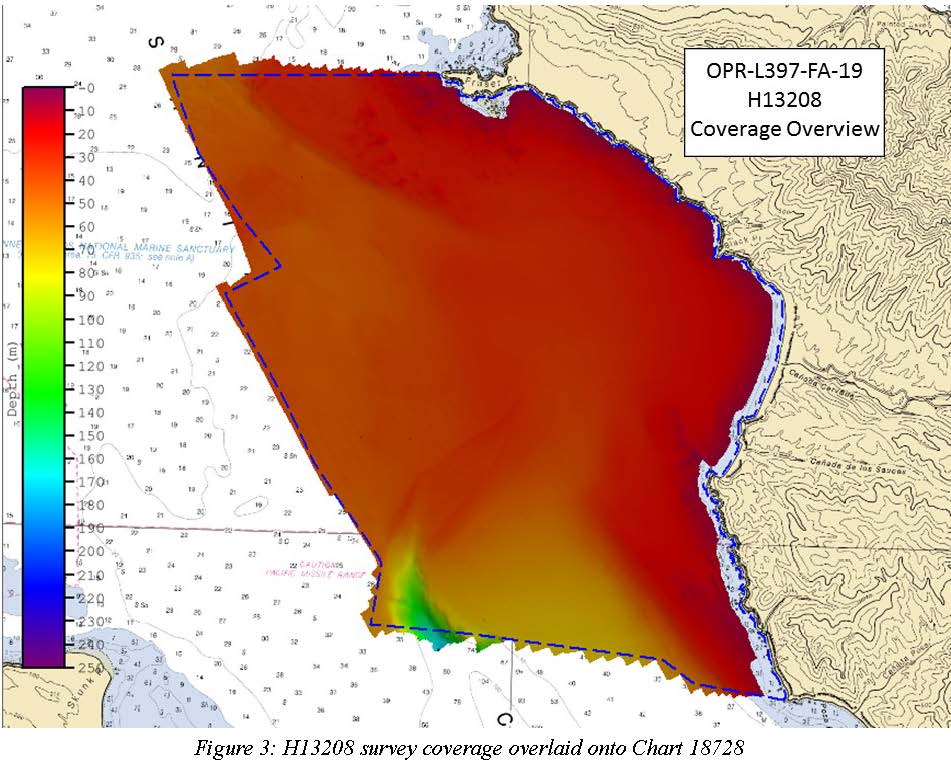
Federal
H13208: NOS Hydrographic Survey , 2019-10-14
National Oceanic and Atmospheric Administration, Department of Commerce —
The National Oceanic and Atmospheric Administration (NOAA) has the statutory mandate to collect hydrographic data in support of nautical chart compilation for safe... -
Federal
Downscaled projections of Sea Surface Temperatures and Degree Heating Weeks in the wider Caribbean and Gulf of Mexico
National Oceanic and Atmospheric Administration, Department of Commerce —
Projections of the onset of annual coral bleaching conditions in the Caribbean under Representative Concentration Pathway (RCP) 8.5 are produced using an ensemble of... -
Federal
Gulf of Mexico Hypoxia Watch Bottom Dissolved Oxygen Contours for October and November SEAMAP Cruise of 2008
National Oceanic and Atmospheric Administration, Department of Commerce —
The NOAA Hypoxia Watch project provides near-real-time, web-based maps of dissolved oxygen near the sea floor over the Texas-Louisiana continental shelf during a... -
Federal
H13750: NOS Hydrographic Survey , 2024-05-22
National Oceanic and Atmospheric Administration, Department of Commerce —
The National Oceanic and Atmospheric Administration (NOAA) has the statutory mandate to collect hydrographic data in support of nautical chart compilation for safe... -
Federal
1994 Average Monthly Sea Surface Temperature for California
National Oceanic and Atmospheric Administration, Department of Commerce —
The NOAA/ NASA AVHRR Oceans Pathfinder sea surface temperature data are derived from the 5-channel Advanced Very High Resolution Radiometers (AVHRR) on board the NOAA...

Official websites use .gov
A
.gov website belongs to an official government
organization in the United States.
Secure .gov websites use HTTPS
A
lock (
) or https:// means you’ve safely connected to
the .gov website. Share sensitive information only on official,
secure websites.