
-
Federal
H12996: NOS Hydrographic Survey , 2017-07-02
National Oceanic and Atmospheric Administration, Department of Commerce —
The National Oceanic and Atmospheric Administration (NOAA) has the statutory mandate to collect hydrographic data in support of nautical chart compilation for safe... -
Federal
NOAA TIFF Image - 3m Bathymetry Slope, Florida Deep Coral Areas - Lost Coast Explorer - (2010), UTM 17N NAD83
National Oceanic and Atmospheric Administration, Department of Commerce —
This dataset contains a unified GeoTiff with 3x3 meter cell size representing the slope (in degrees) of several deep coral priority areas off the Atlantic Coast of... -
Federal
H13176: NOS Hydrographic Survey , 2019-06-21
National Oceanic and Atmospheric Administration, Department of Commerce —
The National Oceanic and Atmospheric Administration (NOAA) has the statutory mandate to collect hydrographic data in support of nautical chart compilation for safe... -
Federal
H13927: NOS Hydrographic Survey , 2024-09-27
National Oceanic and Atmospheric Administration, Department of Commerce —
The National Oceanic and Atmospheric Administration (NOAA) has the statutory mandate to collect hydrographic data in support of nautical chart compilation for safe... -
Federal
H13706: NOS Hydrographic Survey , 2023-06-27
National Oceanic and Atmospheric Administration, Department of Commerce —
The National Oceanic and Atmospheric Administration (NOAA) has the statutory mandate to collect hydrographic data in support of nautical chart compilation for safe... -
Federal
F00634: NOS Hydrographic Survey , 2013-06-04
National Oceanic and Atmospheric Administration, Department of Commerce —
The National Oceanic and Atmospheric Administration (NOAA) has the statutory mandate to collect hydrographic data in support of nautical chart compilation for safe... -
Federal
CRED 20 m Gridded bathymetry and IKONOS estimated depths of Pearl and Hermes Atoll, Hawaii, USA (NetCDF format)
National Oceanic and Atmospheric Administration, Department of Commerce —
Gridded bathymetry and IKONOS estimated depths of the shelf and slope environments of Pearl and Hermes Atoll, Hawaii, USA. Bottom coverage was achieved in depths... -
Federal
Benthic Habitats of Puerto Rico and the U.S. Virgin Islands;Photomosaic of Puerto Rico (Ponce), 1999
National Oceanic and Atmospheric Administration, Department of Commerce —
Habitat maps of Puerto Rico and the U.S. Virgin Islands were created by visual interpretation of aerial photographs using the Habitat Digitizer Extension. Aerial... -
Federal
Spring Bottom Trawl Survey
National Oceanic and Atmospheric Administration, Department of Commerce —
The standardized NEFSC Spring Bottom Trawl Survey was initiated in 1968 and covered an area from Cape Hatteras, NC, to Nova Scotia, Canada, at depths >27m.... -
Federal
Bathymetric Position Index (BPI) Zones Grid Derived from Gridded Bathymetry for Select U.S. Coral Reef Locations across the Pacific Ocean
National Oceanic and Atmospheric Administration, Department of Commerce —
Bathymetric Position Index (BPI) Zones are derived for islands and banks across the U.S. Pacific Islands Region from a focal mean analysis on bathymetry and slope,... -
Federal
H13172: NOS Hydrographic Survey , 2019-03-29
National Oceanic and Atmospheric Administration, Department of Commerce —
The National Oceanic and Atmospheric Administration (NOAA) has the statutory mandate to collect hydrographic data in support of nautical chart compilation for safe... -
Federal
H11477: NOS Hydrographic Survey , Southwest Alaska Peninsula,. Alaska, 2005-08-21
National Oceanic and Atmospheric Administration, Department of Commerce —
The National Oceanic and Atmospheric Administration (NOAA) has the statutory mandate to collect hydrographic data in support of nautical chart compilation for safe... -
Federal
H13930: NOS Hydrographic Survey , 2024-09-27
National Oceanic and Atmospheric Administration, Department of Commerce —
The National Oceanic and Atmospheric Administration (NOAA) has the statutory mandate to collect hydrographic data in support of nautical chart compilation for safe... -
Federal
H13177: NOS Hydrographic Survey , 2019-03-02
National Oceanic and Atmospheric Administration, Department of Commerce —
The National Oceanic and Atmospheric Administration (NOAA) has the statutory mandate to collect hydrographic data in support of nautical chart compilation for safe... -
Federal
Red Porgy Reproductive Analysis
National Oceanic and Atmospheric Administration, Department of Commerce —
Protogynous fishes are often assumed to be more sensitive than gonochorists to exploitation, primarily because of potential sperm limitation and/or social disruption... -
Federal
Slope Grid Derived from Gridded Bathymetry for Select U.S. Coral Reef Locations across the Pacific Ocean
National Oceanic and Atmospheric Administration, Department of Commerce —
Slope is derived for islands and banks across the U.S. Pacific Islands Region primarily from gridded multibeam bathymetry collected aboard NOAA Ships Hi'ialakai and... -
Federal
ASV_SEISMICSHOT500 - Shot Points at 500 Shot Intervals for Seismic Data Collected with Autonomous Surface Vehicle (ASV) IRIS in Apalachicola Bay and St. George Sound, FL.
National Oceanic and Atmospheric Administration, Department of Commerce —
These data were collected under a cooperative mapping program between the U.S. Geological Survey (USGS), the National Oceanic and Atmospheric Administration Office... -
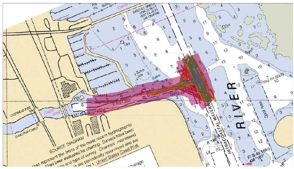
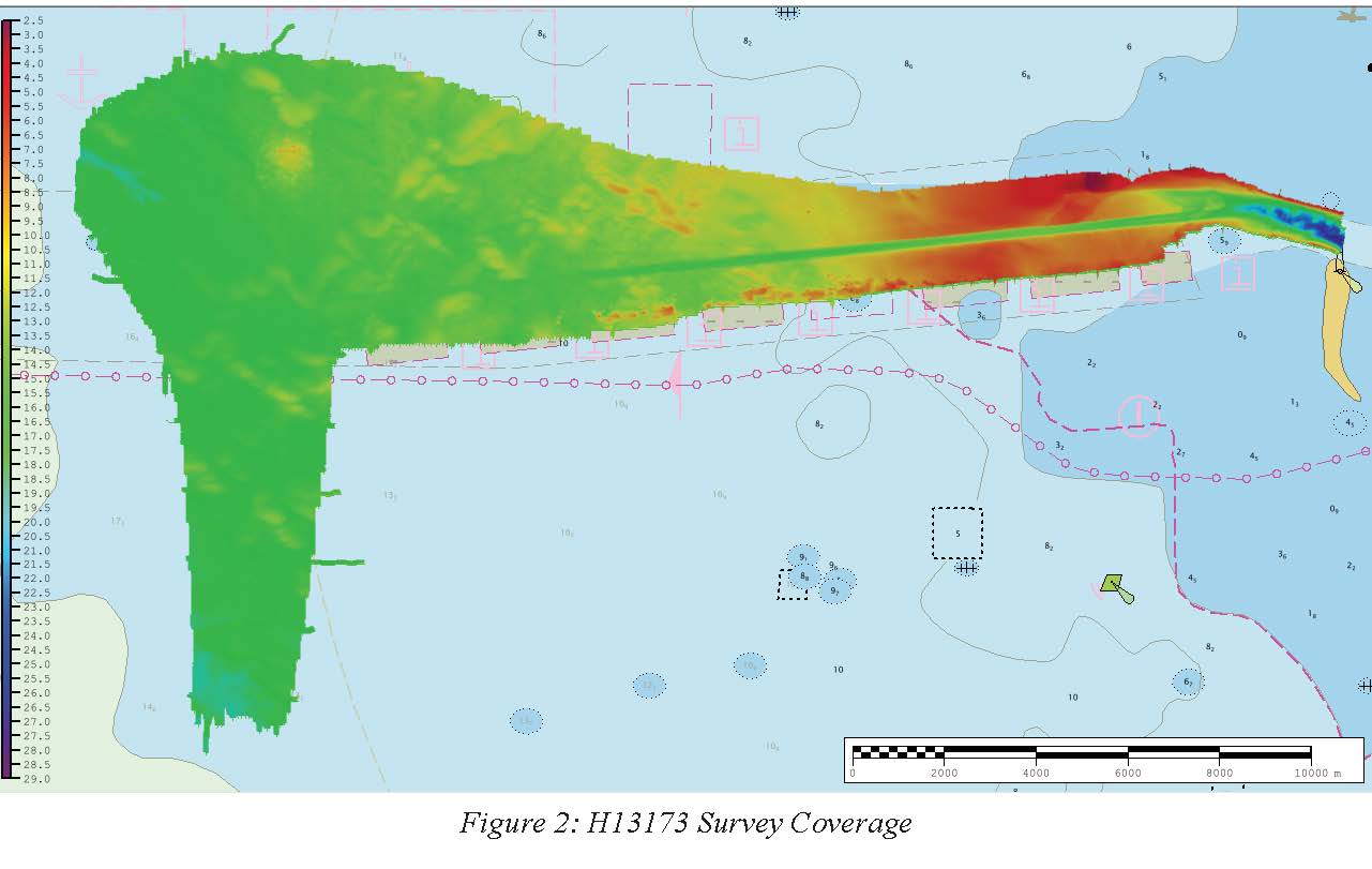
Federal
H13173: NOS Hydrographic Survey , 2019-07-21
National Oceanic and Atmospheric Administration, Department of Commerce —
The National Oceanic and Atmospheric Administration (NOAA) has the statutory mandate to collect hydrographic data in support of nautical chart compilation for safe... -
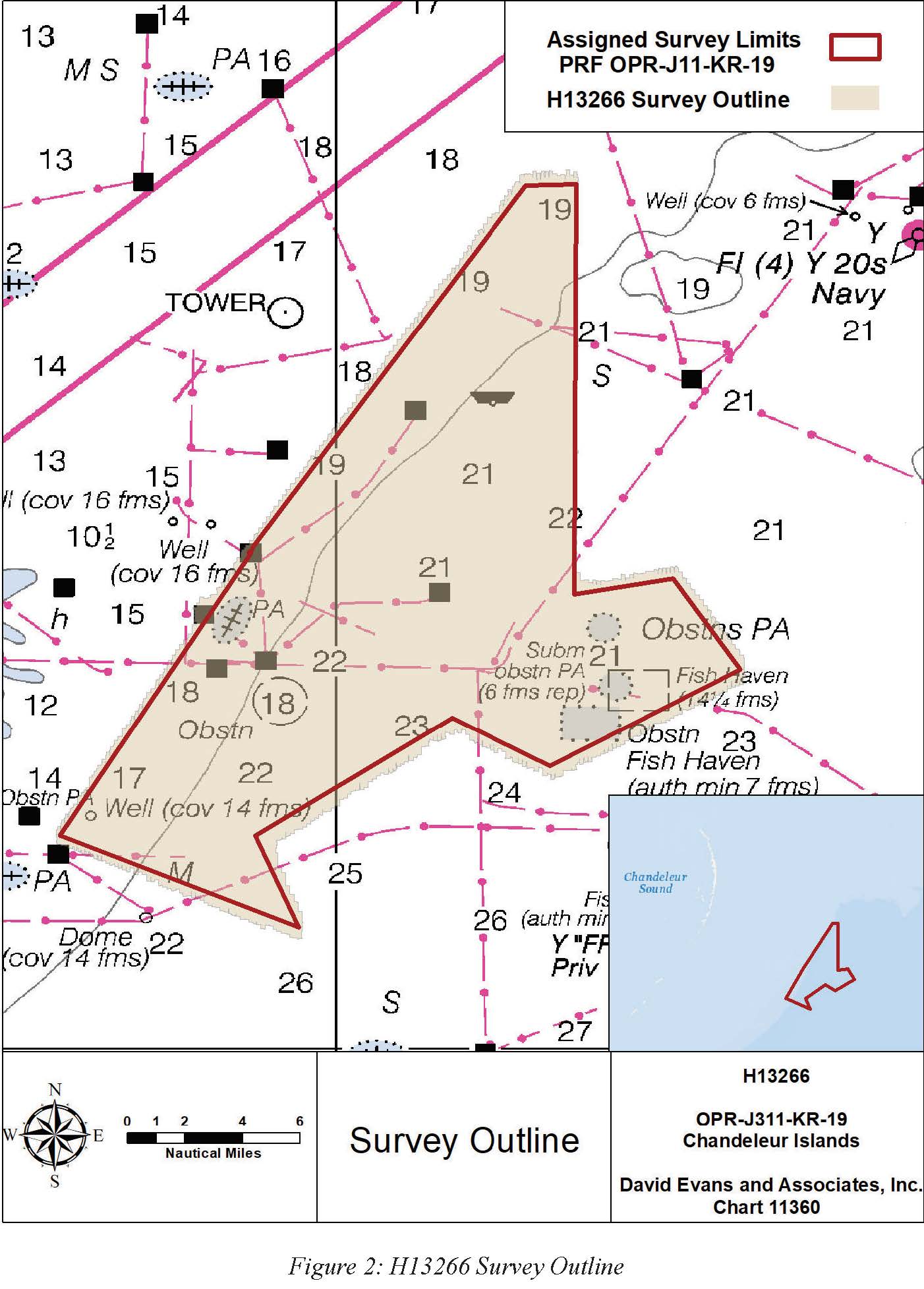
Federal
H13266: NOS Hydrographic Survey , 2020-01-14
National Oceanic and Atmospheric Administration, Department of Commerce —
The National Oceanic and Atmospheric Administration (NOAA) has the statutory mandate to collect hydrographic data in support of nautical chart compilation for safe...

Official websites use .gov
A
.gov website belongs to an official government
organization in the United States.
Secure .gov websites use HTTPS
A
lock (
) or https:// means you’ve safely connected to
the .gov website. Share sensitive information only on official,
secure websites.