
-
Federal
Munitions and Explosives of Concern
National Oceanic and Atmospheric Administration, Department of Commerce —
Munitions and explosives of concern (MEC) have been deposited on the seabed of the United States outer continental shelf since World War I. The bulk of these... -
Federal
Map of percent scleractinian coral cover along camera tows and ROV tracks in the Auau Channel, Island of Maui, Hawaii
National Oceanic and Atmospheric Administration, Department of Commerce —
This map displays optical validation observation locations and percent coverage of scleractinian coral overlaid on bathymetry and landsat imagery. Optical data were... -
Federal
Atlantic Surfclam and Ocean Quahog Survey
National Oceanic and Atmospheric Administration, Department of Commerce —
The standardized NEFSC Atlantic Surfclam and Ocean Quahog Survey has covered an area from Cape Hatteras to Georges Bank. The survey was conducted every two or three... -
Federal
NOAA/WDS Paleoclimatology - Jackson, S.T., Heart Lake (HEARTLK1) North American Plant Macrofossil Database
National Oceanic and Atmospheric Administration, Department of Commerce —
This archived Paleoclimatology Study is available from the NOAA National Centers for Environmental Information (NCEI), under the World Data Service (WDS) for... -
Federal
NOAA/WDS Paleoclimatology - Bennike, O., Fortunebay Lake (FORTUBAY) North American Plant Macrofossil Database
National Oceanic and Atmospheric Administration, Department of Commerce —
This archived Paleoclimatology Study is available from the NOAA National Centers for Environmental Information (NCEI), under the World Data Service (WDS) for... -
Federal
H11706: NOS Hydrographic Survey , Chatham Strait, Alaska, 2007-05-25
National Oceanic and Atmospheric Administration, Department of Commerce —
The National Oceanic and Atmospheric Administration (NOAA) has the statutory mandate to collect hydrographic data in support of nautical chart compilation for safe... -
Federal
H13069: NOS Hydrographic Survey , 2017-10-30
National Oceanic and Atmospheric Administration, Department of Commerce —
The National Oceanic and Atmospheric Administration (NOAA) has the statutory mandate to collect hydrographic data in support of nautical chart compilation for safe... -
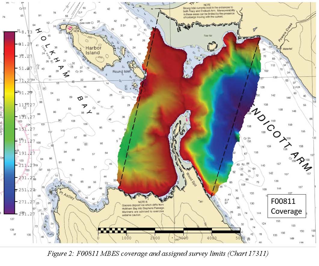
Federal
F00811: NOS Hydrographic Survey , 2020-10-10
National Oceanic and Atmospheric Administration, Department of Commerce —
The National Oceanic and Atmospheric Administration (NOAA) has the statutory mandate to collect hydrographic data in support of nautical chart compilation for safe... -
Federal
H11691: NOS Hydrographic Survey , West of Prince of Wales Island, Alaska, 2007-07-28
National Oceanic and Atmospheric Administration, Department of Commerce —
The National Oceanic and Atmospheric Administration (NOAA) has the statutory mandate to collect hydrographic data in support of nautical chart compilation for safe... -
Federal
Military Surface Grid Areas within the Atlantic and Gulf of Mexico
National Oceanic and Atmospheric Administration, Department of Commerce —
A regular pattern of polygons that represent arbitrary delineations of an Operating Area (OPAREA). These data are a subset of the Navy's Common Operating Picture for... -
Federal
2002 Long Island South Shore Estuary Benthic Habitat Polygon Data Set Biotic
National Oceanic and Atmospheric Administration, Department of Commerce —
In June 2002, 200 1:20,000 scale conventional-color metric film diapositives for Long Island, New York were collected as part of an effort to map submerged aquatic... -
Federal
H11760: NOS Hydrographic Survey , Endicott Arm, Alaska, 2007-11-01
National Oceanic and Atmospheric Administration, Department of Commerce —
The National Oceanic and Atmospheric Administration (NOAA) has the statutory mandate to collect hydrographic data in support of nautical chart compilation for safe... -
Federal
2002 Long Island South Shore Estuary Benthic Habitat Polygon Data Set Substrate
National Oceanic and Atmospheric Administration, Department of Commerce —
In June 2002, 200 1:20,000 scale conventional-color metric film diapositives for Long Island, New York were collected as part of an effort to map submerged aquatic... -
Federal
NOAA/WDS Paleoclimatology - Anderson, R.S., Gould Pond (GOULD) North American Plant Macrofossil Database
National Oceanic and Atmospheric Administration, Department of Commerce —
This archived Paleoclimatology Study is available from the NOAA National Centers for Environmental Information (NCEI), under the World Data Service (WDS) for... -
Federal
NOAA/WDS Paleoclimatology - Kearsley, J.B., Valhalla Hollow (VALHALLA) North American Plant Macrofossil Database
National Oceanic and Atmospheric Administration, Department of Commerce —
This archived Paleoclimatology Study is available from the NOAA National Centers for Environmental Information (NCEI), under the World Data Service (WDS) for... -
Federal
NOAA/WDS Paleoclimatology - CoralHydro2k Database (Common Era coral d18O and Sr/Ca data compilation)
National Oceanic and Atmospheric Administration, Department of Commerce —
This archived Paleoclimatology Study is available from the NOAA National Centers for Environmental Information (NCEI), under the World Data Service (WDS) for... -
Federal
Industry Based Monkfish Survey
National Oceanic and Atmospheric Administration, Department of Commerce —
Monkfish industry leaders expressed concerns that the NEFSC bottom trawl surveys did not sample in all monkfish habitats; particularly the deeper water outside the... -
Federal
2002 Long Island South Shore Estuary Benthic Habitat Polygon Data Set Geodatabase
National Oceanic and Atmospheric Administration, Department of Commerce —
In June 2002, 200 1:20,000 scale conventional-color metric film diapositives for Long Island, New York were collected as part of an effort to map submerged aquatic... -
Federal
H12133: NOS Hydrographic Survey , Thunder Bay, Michigan, 2011-11-23
National Oceanic and Atmospheric Administration, Department of Commerce —
The National Oceanic and Atmospheric Administration (NOAA) has the statutory mandate to collect hydrographic data in support of nautical chart compilation for safe... -
Federal
H11677: NOS Hydrographic Survey , Approaches to Sitka, Alaska, 2007-06-02
National Oceanic and Atmospheric Administration, Department of Commerce —
The National Oceanic and Atmospheric Administration (NOAA) has the statutory mandate to collect hydrographic data in support of nautical chart compilation for safe...

Official websites use .gov
A
.gov website belongs to an official government
organization in the United States.
Secure .gov websites use HTTPS
A
lock (
) or https:// means you’ve safely connected to
the .gov website. Share sensitive information only on official,
secure websites.
.jpg)
.jpg)