
-
Federal
NCCOS Assessment: Modeling at-sea density of marine birds to support renewable energy planning on the Pacific Outer Continental Shelf of the contiguous United States (NCEI Accession 0242882)
National Oceanic and Atmospheric Administration, Department of Commerce —
This dataset provides seasonal spatial rasters of predicted long-term (1980-2017) density of 33 individual species and 13 taxonomic groups of marine birds throughout... -
Federal
Hawaii Volcanism: Impact on the Environment
National Oceanic and Atmospheric Administration, Department of Commerce —
Fewer than one hundred people have been killed by eruptions in the recorded history of Hawaii, and only one death has occurred in the 20th Century. However, the lava... -
Federal
2023 NOAA Topobathy Lidar: Northern Lake Michigan & Northern Lake Huron, MI
National Oceanic and Atmospheric Administration, Department of Commerce —
Product: This topobathy lidar dataset consists of processed classified LAS 1.4 files used to create intensity images and topobathymetric DEMs as necessary. Three... -
Federal
Bathymetry of Lake Huron
National Oceanic and Atmospheric Administration, Department of Commerce —
Bathymetry of Lake Huron has been compiled as a component of a NOAA project to rescue Great Lakes lake floor geological and geophysical data and make it more... -
Federal
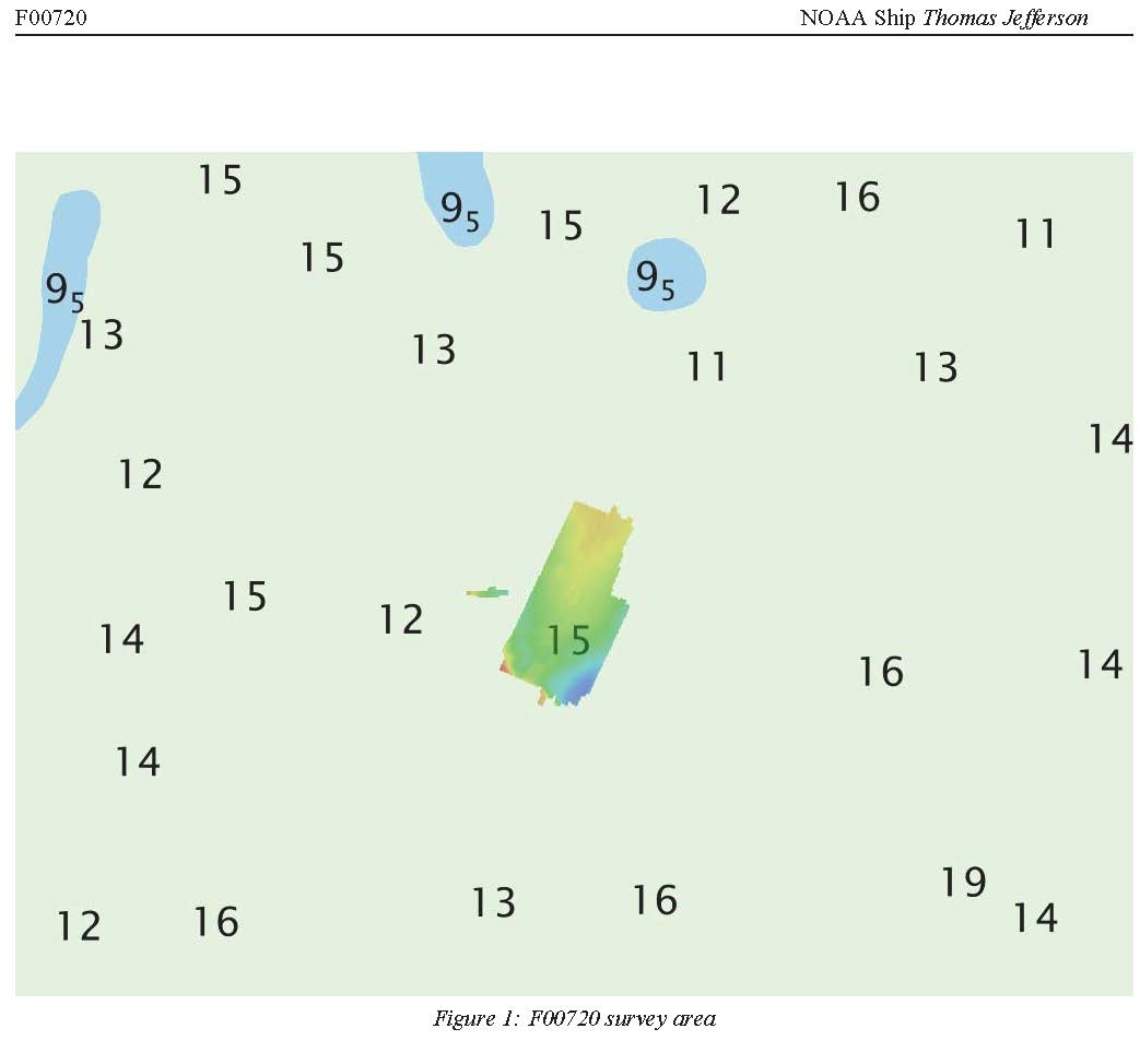
F00720: NOS Hydrographic Survey , 2018-05-01
National Oceanic and Atmospheric Administration, Department of Commerce —
The National Oceanic and Atmospheric Administration (NOAA) has the statutory mandate to collect hydrographic data in support of nautical chart compilation for safe... -
Federal
Limits of Resilience: Uncertain Recovery in Mangrove Ecosystems Following Repeated Hurricane Disturbance - NERRS/NSC(NERRS Science Collaborative)
National Oceanic and Atmospheric Administration, Department of Commerce —
Building on the momentum of an earlier collaborative project, this team and their users reunited to assess how mangrove recovery and resilience is impacted by... -
Federal
Bathymetry of Lake Ontario
National Oceanic and Atmospheric Administration, Department of Commerce —
Bathymetry of Lake Ontario has been compiled as a component of a NOAA project to rescue Great Lakes lake floor geological and geophysical data and make it more... -
Federal
Distance to Nearest Coastline: 0.01-Degree Grid: Land
National Oceanic and Atmospheric Administration, Department of Commerce —
A global data set of land distances from the nearest coastline. NASA's Ocean Biology Processing Group (OBPG) generated this data set using the Generic Mapping Tools... -
Federal
2018-2019 NOAA NGS Topobathy Lidar DEM Hurricane Irma Delivery 1: Miami to Key Largo, FL
National Oceanic and Atmospheric Administration, Department of Commerce —
The NOAA Hurricane Irma Florida Keys Topobathymetric LiDAR Delivery 1 area data were collected by Quantum Spatial, Inc. (QSI) using three Riegl systems: a Riegl... -
Federal
AFSC/RACE/SAP: Detailed Crab Data From NOAA Fisheries Service 2012 Chukchi Sea Bottom Trawl Surveys
National Oceanic and Atmospheric Administration, Department of Commerce —
This dataset contains detailed crab data collected from the 2012 NOAA/NMFS/AFSC/RACE crab-groundfish bottom trawl survey of the Chukchi Sea. 71 survey stations were... -
Federal
Sea ice meiofauna abundance in coastal fast ice off Barrow, Alaska, with a focus on Scolelepis squamata (Polychaeta), July 12, 2005 - April 4, 2006 (NCEI Accession 0064869)
National Oceanic and Atmospheric Administration, Department of Commerce —
The fast ice along the Alaskan coastline forms in November/December and reaches a thickness of 1.5-1.8m by April. Break-up usually occurs between late June and mid-... -
Federal
Monitoring of coral reef ecosystems on the Island of Hawaii from 22 May 1999 to 25 May 1999 through the Quantitative Underwater Ecological Surveying Techniques (QUEST) project (NCEI Accession 0000264)
National Oceanic and Atmospheric Administration, Department of Commerce —
In an effort to detect spatial and temporal changes in the structure of the coral reef community, coral coverage and reef fish density and diversity were documented... -
Federal
BENTHIC SPECIES and Other Data from UNKNOWN From North American Coastline-North for 1990-10-10 (NCEI Accession 7400205)
National Oceanic and Atmospheric Administration, Department of Commerce —
This dataset is a Moriches Bay benthic fauna study. -
Federal
WorldView-2 Satellite Image Inventory for Timor-Leste
National Oceanic and Atmospheric Administration, Department of Commerce —
Inventory of satellite images from DigitalGlobeâs WorldView-2 satellite purchased by the NOAA Coral Reef Ecosystem Program for Timor-leste from Jan 26, 2010 to... -
Federal
NCCOS Assessment: U.S. West Coast Cross-Shelf Habitat Suitability Modeling of Deep-Sea Corals and Sponges, 2016-10-01 to 2020-09-30 (NCEI Accession 0276883)
National Oceanic and Atmospheric Administration, Department of Commerce —
This data collection contains geospatial data from models predicting the spatial distributions of deep-sea corals and sponges offshore of the continental U.S. West... -
Federal
Cloud amount/frequency, NITRATE and other data from NOAA Ship WHITING in the North American Coastline-North from 1990-04-20 to 1990-06-28 (NCEI Accession 9000151)
National Oceanic and Atmospheric Administration, Department of Commerce —
The Conductivity, Temperature and Depth (CTD) and other data were collected using SEACAT recorders from North American Coast line. NOAA Ship Whiting was used to... -
Federal
Tropical Cyclone Wind Exposure
National Oceanic and Atmospheric Administration, Department of Commerce —
Hurricanes and other tropical cyclones pose a high risk to people, property, and ecosystems along the coastline of the United States. The impact of these storms can... -
Federal
PARTICULATE ORGANIC CARBON, cloud amount/frequency and other data from COLUMBUS ISELIN in the North American Coastline-South and South Atlantic Ocean from 1990-05-23 to 1990-06-13 (NCEI Accession 9100150)
National Oceanic and Atmospheric Administration, Department of Commerce —
Data was collected from R/V COLUMBUS ISELIN in South Atlantic Ocean and North American Coast line-South during the Amazon Shelf Sediment Study (AMASSEDS) between May...

Official websites use .gov
A
.gov website belongs to an official government
organization in the United States.
Secure .gov websites use HTTPS
A
lock (
) or https:// means you’ve safely connected to
the .gov website. Share sensitive information only on official,
secure websites.