
-
Federal
Fisheries One Stop Shop Public Data 2009 - Present
National Oceanic and Atmospheric Administration, Department of Commerce —
The purpose of the Fisheries One-Stop-Shop (FOSS) is to make fisheries dependent information readily available to fisheries managers, scientists and the American... -
Federal
NOAA Point Shapefile- Benthic Habitat Classifications from Minibat ROV Underwater Video, US Virgin Islands, Project NF-04-06, 2004, UTM 20N WGS84
National Oceanic and Atmospheric Administration, Department of Commerce —
This dataset contains a point shapefile with benthic habitat classifications of vertical relief, geomorphological structure, substrate, and biological cover for... -
Federal
NOAA TIFF Graphic- 0.5m Backscatter Mosaic of St. Croix (Buck Island), US Virgin Islands, 2004
National Oceanic and Atmospheric Administration, Department of Commerce —
This geotiff represents a 0.5 meter resolution backscatter mosaic of the north shore of Buck Island, St. Croix, US Virgin Islands.NOAA's NOS/NCCOS/CCMA Biogeography... -
Federal
American Samoa ESI: ESI (Environmental Sensitivity Index Shoreline Types - Polygons and Lines)
National Oceanic and Atmospheric Administration, Department of Commerce —
This data set contains vector lines and polygons representing the shoreline and coastal habitats of American Samoa classified according to the Environmental... -
Federal
Bristol Bay, Alaska Subarea ESI: M_MAMMAL (Marine Mammal Polygons)
National Oceanic and Atmospheric Administration, Department of Commerce —
This data set contains sensitive biological resource data for seals, whales, porpoises, walruses, sea otters, and Steller sea lions in the Bristol Bay Subarea. The... -
Federal
NOAA TIFF Graphic- 0.5m Backscatter Mosaic of St. Thomas, US Virgin Islands, 2004
National Oceanic and Atmospheric Administration, Department of Commerce —
This image represents a 0.5 meter resolution backscatter mosaic of the south shore of St. Thomas, US Virgin Islands.NOAA's NOS/NCCOS/CCMA Biogeography Team and... -
Federal
NOAA TIFF Image - 3x3m Multibeam Backscatter, US Virgin Islands - Vieques Island (South Bank) - Project NF-09-01 - (2009), UTM 20N NAD83
National Oceanic and Atmospheric Administration, Department of Commerce —
This dataset contains a GeoTIFF with 3x3 meter cell size representing the backscatter or intensity of sound returned from the seafloor on the bank/shelf escarpment... -
Federal
Bristol Bay, Alaska Subarea ESI: M_MAMPT (Marine Mammal Points)
National Oceanic and Atmospheric Administration, Department of Commerce —
This data set contains sensitive biological resource data for Steller sea lions and seals in the Bristol Bay Subarea. The Subarea includes marine and coastal areas of... -
Federal
Columbia River ESI: HYDRO (Hydrography Lines and Polygons)
National Oceanic and Atmospheric Administration, Department of Commerce —
This data set contains vector lines and polygons representing coastal hydrography used in the creation of the Environmental Sensitivity Index (ESI) for Columbia... -
Federal
Sensitivity of Coastal Environments and Wildlife to Spilled Oil: New Hampshire: REPTILES (Reptile Polygons)
National Oceanic and Atmospheric Administration, Department of Commerce —
This data set contains sensitive biological resource data for estuarine turtles in New Hampshire. Vector polygons in this data set represent turtle distribution.... -
Federal
Columbia River ESI: T_MAMMAL (Terrestrial Mammal Polygons)
National Oceanic and Atmospheric Administration, Department of Commerce —
This data set contains sensitive biological resource data for beavers, otters, nutria, mink, muskrats, and Columbian white-tailed deer in the Columbia River area.... -
Federal
Bristol Bay, Alaska Subarea ESI: HABITATS (Habitats Polygons)
National Oceanic and Atmospheric Administration, Department of Commerce —
This data set contains sensitive biological resource data for submerged aquatic vegetation (SAV) in the Bristol Bay Subarea. The Subarea includes marine and coastal... -
Federal
2004 Alaska Lidar Mapping
National Oceanic and Atmospheric Administration, Department of Commerce —
The data sets are generated using the OPTECH ALTM 70 kHz LIDAR system mounted onboard AeroMap's twin-engine Cessna 320 aircraft. Classified data sets such as this one... -
Federal
Columbia River ESI: M_MAMPT (Marine Mammal Points)
National Oceanic and Atmospheric Administration, Department of Commerce —
This data set contains sensitive biological resource data for sea lions and harbor seals in Columbia River. Vector points in this data set represent locations of seal... -
Federal
American Samoa ESI: T_MAMPT (Terrestrial Mammal Points)
National Oceanic and Atmospheric Administration, Department of Commerce —
This data set contains sensitive biological resource data for bats in American Samoa. Vector points in this data set represent bat roosts and caves. Species-specific... -
Federal
NOAA ESRI Geotiff- 1m Bathymetry of St. Thomas, US Virgin Islands, 2004, UTM 20 WGS84
National Oceanic and Atmospheric Administration, Department of Commerce —
This dataset contains an ESRI Geotiff with 1 meter cell size representing the bathymetry of the south shore of St. Thomas, US Virgin Islands.NOAA's NOS/NCCOS/CCMA... -
Federal
NOAA TIFF Image - 2m Multibeam Bathymetry, US Virgin Islands - Vieques Island - Project NF-09-01 - (2009), UTM 20N NAD83
National Oceanic and Atmospheric Administration, Department of Commerce —
This dataset contains a unified ESRI Geotiff with 2x2 meter cell size representing the bathymetry of a selected portion of seafloor southwest of Vieques Island,... -
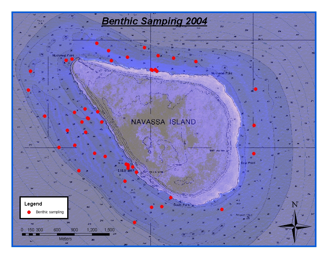
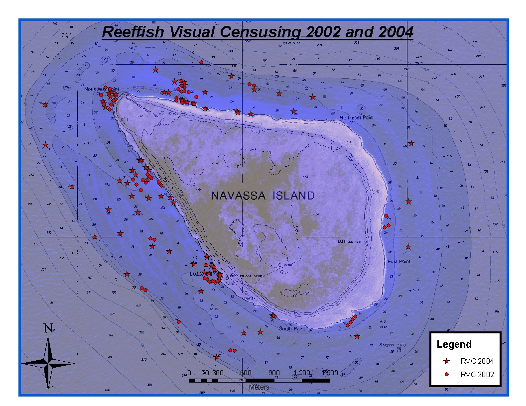
Federal
CRCP-Navassa reef assessment
National Oceanic and Atmospheric Administration, Department of Commerce —
Episodic cruises ( every 2 years) were conducted to perform assessments of Navassa Island coral reef resources including reeffish visual census, benthic reef... -
Federal
Loggerhead oral cavity morphometry study (NCEI Accession 0164321)
National Oceanic and Atmospheric Administration, Department of Commerce —
Standard external morphometrics and internal oral cavity morphometrics data were collected on wild and captive reared loggerhead sea turtles in size classes ranging... -
Federal
American Samoa ESI: CASSPT (Coral Areas of Special Significance - Points)
National Oceanic and Atmospheric Administration, Department of Commerce —
This data set contains sensitive biological resource data for "Coral Areas of Special Significance" in American Samoa. Coral Areas of Special Significance were...

Official websites use .gov
A
.gov website belongs to an official government
organization in the United States.
Secure .gov websites use HTTPS
A
lock (
) or https:// means you’ve safely connected to
the .gov website. Share sensitive information only on official,
secure websites.