
-
Federal
H13197: NOS Hydrographic Survey , 2018-10-29
National Oceanic and Atmospheric Administration, Department of Commerce —
The National Oceanic and Atmospheric Administration (NOAA) has the statutory mandate to collect hydrographic data in support of nautical chart compilation for safe... -
Federal
Shoreline Data Rescue Project of Southern California, CA1934A NGDA
National Oceanic and Atmospheric Administration, Department of Commerce —
These data were automated to provide an accurate high-resolution historical shoreline of Southern California suitable as a geographic information system (GIS) data... -
Federal
Sensitivity of Coastal Environments and Wildlife to Spilled Oil: Southern California: MGT (Management Area Polygons)
National Oceanic and Atmospheric Administration, Department of Commerce —
This data set contains sensitive human-use data for critical habitats, fishery areas, management areas, marine sanctuaries, national forests, national parks, The... -
Federal
Santa Monica, California 1/3 arc-second NAVD 88 Coastal Digital Elevation Model
National Oceanic and Atmospheric Administration, Department of Commerce —
NOAA's National Geophysical Data Center (NGDC) is building high-resolution digital elevation models (DEMs) for select U.S. coastal regions. These integrated... -
Federal
Nearshore marine fish assemblages in southern California
National Oceanic and Atmospheric Administration, Department of Commerce —
Fish benthic trawls were completed by the Southern California Coastal Water Research Project (SCCWRP). Data from 425 fisheries independent trawls ranging from 2-215... -
Federal
San Diego, California 1/3 Arc-second MHW Coastal Digital Elevation Model
National Oceanic and Atmospheric Administration, Department of Commerce —
NOAA's National Geophysical Data Center (NGDC) is building high-resolution digital elevation models (DEMs) for select U.S. coastal regions. These integrated... -
Federal
Fish assemblages in southern California kelp forests.
National Oceanic and Atmospheric Administration, Department of Commerce —
This is a point file of fish assemblages calculated from diver surveys in kelp forests in Southern California. Visual census data was combined for two separate... -
Federal
Rockcrabs of the genus Cancer habitat suitability model for Channel Islands National Marine Sanctuary Biogeographic Assessment
National Oceanic and Atmospheric Administration, Department of Commerce —
The National Marine Sanctuary Program (NMSP) updates and revises the management plans for each of its 13 sanctuaries. This process, which is open to the public,... -
Federal
Sensitivity of Coastal Environments and Wildlife to Spilled Oil: Southern California: NESTS (Nest Points)
National Oceanic and Atmospheric Administration, Department of Commerce —
This data set contains sensitive biological resource data for nesting and roosting gulls, terns, seabirds, shorebirds, and T/E species in Southern California. Vector... -
Federal
Sensitivity of Coastal Environments and Wildlife to Spilled Oil: Southern California: ESI (Shoreline Types - Lines and Polygons)
National Oceanic and Atmospheric Administration, Department of Commerce —
This data set contains vector lines and polygons representing the shoreline and coastal habitats of Southern California, classified according to the Environmental... -
Federal
Sensitivity of Coastal Environments and Wildlife to Spilled Oil: Southern California: T_MAMMAL (Terrestrial Mammal Polygons)
National Oceanic and Atmospheric Administration, Department of Commerce —
This data set contains sensitive biological resource data for rare and threatened/endangered terrestrial mammals in Southern California. Vector polygons in this data... -
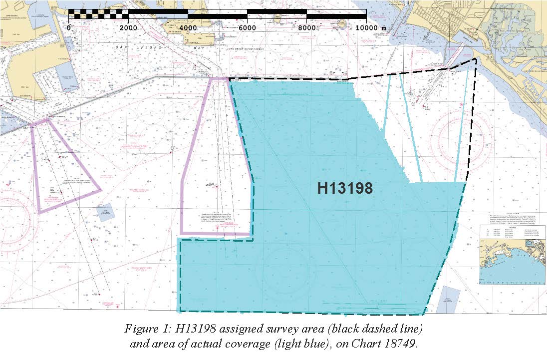
Federal
H13198: NOS Hydrographic Survey , 2018-10-29
National Oceanic and Atmospheric Administration, Department of Commerce —
The National Oceanic and Atmospheric Administration (NOAA) has the statutory mandate to collect hydrographic data in support of nautical chart compilation for safe... -
Federal
Warty sea cucumber habitat suitability model for Channel Islands National Marine Sanctuary Biogeographic Assessment
National Oceanic and Atmospheric Administration, Department of Commerce —
The National Marine Sanctuary Program (NMSP) updates and revises the management plans for each of its 13 sanctuaries. This process, which is open to the public,... -
Federal
California sheephead habitat suitability model for Channel Islands National Marine Sanctuary Biogeographic Assessment
National Oceanic and Atmospheric Administration, Department of Commerce —
The National Marine Sanctuary Program (NMSP) updates and revises the management plans for each of its 13 sanctuaries. This process, which is open to the public,... -
Federal
San Diego, California 1/3 Arc-second NAVD 88 Coastal Digital Elevation Model
National Oceanic and Atmospheric Administration, Department of Commerce —
NOAA's National Geophysical Data Center (NGDC) is building high-resolution digital elevation models (DEMs) for select U.S. coastal regions. These integrated... -
Federal
Santa Monica, California 1/3 arc-second MHW Coastal Digital Elevation Model
National Oceanic and Atmospheric Administration, Department of Commerce —
NOAA's National Geophysical Data Center (NGDC) is building high-resolution digital elevation models (DEMs) for select U.S. coastal regions. These integrated... -
Federal
AVHRR CoastWatch West Coast Regional Node Data, November 1991-March 2004
National Oceanic and Atmospheric Administration, Department of Commerce —
The sea surface temperature (SST) products were derived from NOAA's Polar-orbiting Operational Environmental Satellites (POES) for the coastal United States and... -
Federal
Southern California Hook and Line Survey - 2020 Southern California Shelf Rockfish Hook and Line Survey
National Oceanic and Atmospheric Administration, Department of Commerce —
The Fisheries Research Survey team proposes to conduct the annual Shelf Rockfish Hook and Line Survey during September-October 2020. The survey is an ongoing... -
Federal
Olympic Coast National Marine Sanctuary - grab110_0204 - Sediment grabs within survey area 110_0204 taken from USGS usSeabed
National Oceanic and Atmospheric Administration, Department of Commerce —
Over the past 50 years there has been an explosion in scientific interest, research effort, and information gathered on the geologic sedimentary character of the... -
Federal
Fish diversity in southern California using scuba surveys in kelp forests.
National Oceanic and Atmospheric Administration, Department of Commerce —
The Shannon Index of diversity was calculated from diver surveys on kelp beds in Southern California. Kelp diver visual census data was combined for two separate...

Official websites use .gov
A
.gov website belongs to an official government
organization in the United States.
Secure .gov websites use HTTPS
A
lock (
) or https:// means you’ve safely connected to
the .gov website. Share sensitive information only on official,
secure websites.