
-
Federal
Maritime Limits and Boundaries of United States of America NGDA 45 recent views
National Oceanic and Atmospheric Administration, Department of Commerce —
NOAA is responsible for depicting on its nautical charts the limits of the 12 nautical mile Territorial Sea, 24 nautical mile Contiguous Zone, and 200 nautical mile... -
Federal
Sediment profile image data from October 1995 in the inland bays of New York/New Jersey Harbor
National Oceanic and Atmospheric Administration, Department of Commerce —
Sediment profile images (SPI) of the sediment-water interface were collected using a sediment profiling camera at pre-determined locations in the harbor. Physical,... -
Federal
H13022: NOS Hydrographic Survey , 2017-08-09
National Oceanic and Atmospheric Administration, Department of Commerce —
The National Oceanic and Atmospheric Administration (NOAA) has the statutory mandate to collect hydrographic data in support of nautical chart compilation for safe... -
Federal
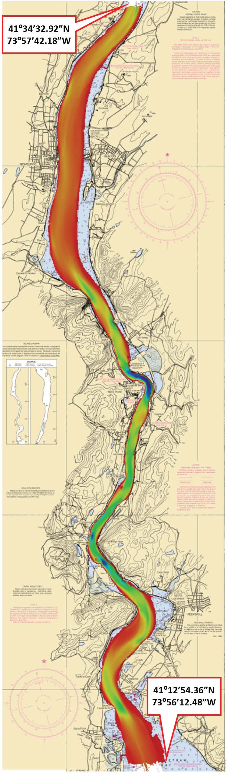
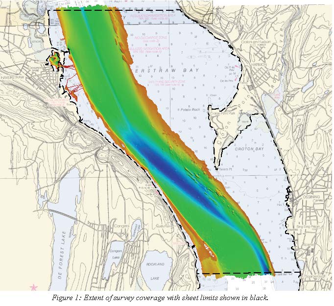
F00596: NOS Hydrographic Survey , Hudson River, New York, 2010-11-26
National Oceanic and Atmospheric Administration, Department of Commerce —
The National Oceanic and Atmospheric Administration (NOAA) has the statutory mandate to collect hydrographic data in support of nautical chart compilation for safe... -
Federal
2002 Long Island South Shore Estuary Benthic Habitat Line Data Set
National Oceanic and Atmospheric Administration, Department of Commerce —
In June 2002, 200 1:20,000 scale conventional-color metric film diapositives for Long Island, New York were collected as part of an effort to map submerged aquatic... -
Federal
Hudson River Sub-Bottom Profile Points
National Oceanic and Atmospheric Administration, Department of Commerce —
Hudson River Estuary Shallow Water Surveys. Subbottom Profile Points. Subbottom data was collected November 5 to December 15, 2009, in the estuary north from... -
Federal
Federal Consistency Geographic Location Descriptions
National Oceanic and Atmospheric Administration, Department of Commerce —
These data represent state geographic location descriptions (GLDs). Section 307 of the Coastal Zone Management Act of 1972, called the "federal consistency"... -
Federal
H13023: NOS Hydrographic Survey , 2017-08-09
National Oceanic and Atmospheric Administration, Department of Commerce —
The National Oceanic and Atmospheric Administration (NOAA) has the statutory mandate to collect hydrographic data in support of nautical chart compilation for safe... -
Federal
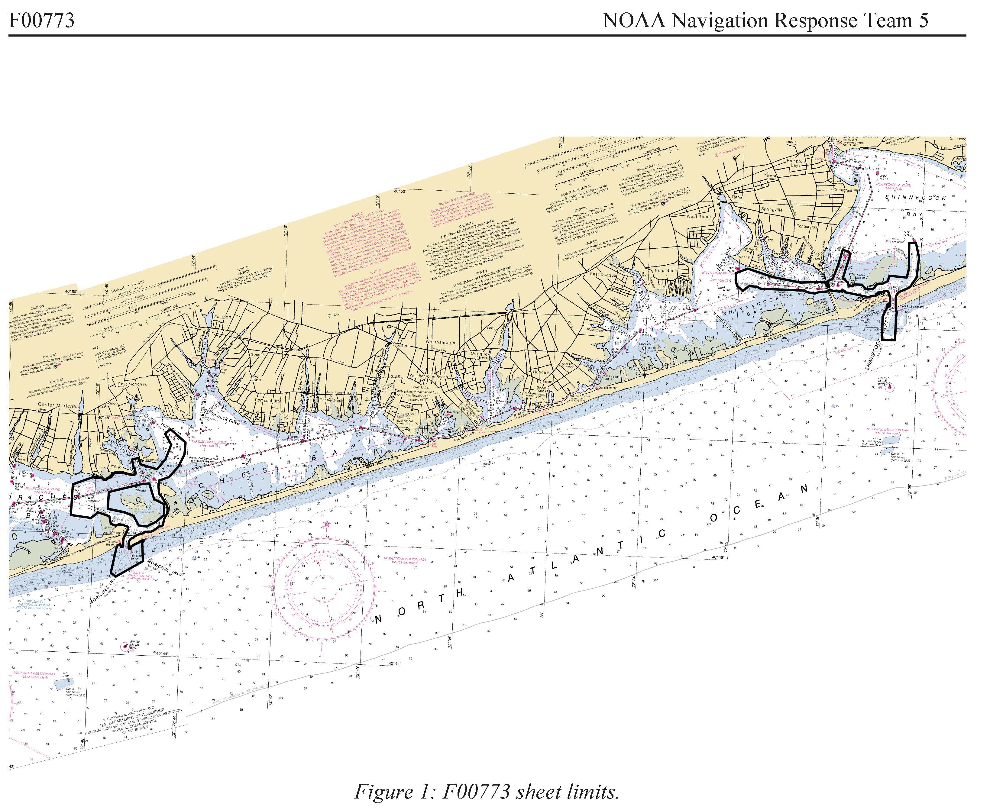
F00773: NOS Hydrographic Survey , 2019-06-07
National Oceanic and Atmospheric Administration, Department of Commerce —
The National Oceanic and Atmospheric Administration (NOAA) has the statutory mandate to collect hydrographic data in support of nautical chart compilation for safe... -
Federal
H12138: NOS Hydrographic Survey , New York Harbor and Approaches, New York and New Jersey, 2009-10-26
National Oceanic and Atmospheric Administration, Department of Commerce —
The National Oceanic and Atmospheric Administration (NOAA) has the statutory mandate to collect hydrographic data in support of nautical chart compilation for safe... -
Federal
H13138: NOS Hydrographic Survey , 2018-08-06
National Oceanic and Atmospheric Administration, Department of Commerce —
The National Oceanic and Atmospheric Administration (NOAA) has the statutory mandate to collect hydrographic data in support of nautical chart compilation for safe... -
Federal
H13386: NOS Hydrographic Survey , 2020-12-11
National Oceanic and Atmospheric Administration, Department of Commerce —
The National Oceanic and Atmospheric Administration (NOAA) has the statutory mandate to collect hydrographic data in support of nautical chart compilation for safe... -
Federal
H13092: NOS Hydrographic Survey , 2017-11-09
National Oceanic and Atmospheric Administration, Department of Commerce —
The National Oceanic and Atmospheric Administration (NOAA) has the statutory mandate to collect hydrographic data in support of nautical chart compilation for safe... -
Federal
H13384: NOS Hydrographic Survey , 2021-03-10
National Oceanic and Atmospheric Administration, Department of Commerce —
The National Oceanic and Atmospheric Administration (NOAA) has the statutory mandate to collect hydrographic data in support of nautical chart compilation for safe... -
Federal
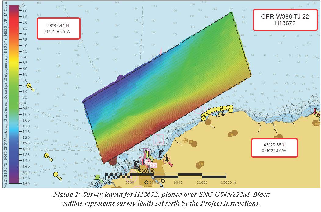
H13672: NOS Hydrographic Survey , 2022-10-11
National Oceanic and Atmospheric Administration, Department of Commerce —
The National Oceanic and Atmospheric Administration (NOAA) has the statutory mandate to collect hydrographic data in support of nautical chart compilation for safe... -
Federal
Benthic grab data from October 1994 in the Lower Bay of New York/New Jersey Harbor
National Oceanic and Atmospheric Administration, Department of Commerce —
Benthic grab samples were collected using a Shipek grab at pre-determined locations in the harbor. Taxonomic enumerations and biological community parameters were... -
Federal
Benthic grab data from June 1995 in the Lower Bay of New York/New Jersey Harbor
National Oceanic and Atmospheric Administration, Department of Commerce —
Benthic grab samples were collected using a Shipek grab at pre-determined locations in the harbor. Taxonomic enumerations and biological community parameters were... -
Federal
Sediment grab data from June 1995 in the inland bays of New York/New Jersey Harbor
National Oceanic and Atmospheric Administration, Department of Commerce —
Sediment grab samples were collected using a Shipek grab at pre-determined locations in the harbor. Grain size distributions and organic content were measured and...

Official websites use .gov
A
.gov website belongs to an official government
organization in the United States.
Secure .gov websites use HTTPS
A
lock (
) or https:// means you’ve safely connected to
the .gov website. Share sensitive information only on official,
secure websites.