
-
Federal
National Coral Reef Monitoring Program: Benthic Cover Derived from Analysis of Benthic Images Collected during Stratified Random Surveys (StRS) across American Samoa in 2015, 2018, and 2023.
National Oceanic and Atmospheric Administration, Department of Commerce —
The data described here result from benthic photo-quadrat surveys conducted along transects at stratified random sites across the American Samoa in 2015, 2018, and... -
Federal
EM300 Multibeam Sonar Data collected from January 26 to April 22 from NOAA Ship Hi'ialakai cruise HA-15-01 to the Pacific Remote Island Areas and American Samoa in 2015
National Oceanic and Atmospheric Administration, Department of Commerce —
Multibeam data were collected using a Simrad EM300 30-kHz sonar aboard NOAA Ship Hi'ialakai, a 68-m (218') NOAA research vessel, from January 26 to April 22, 2015... -
Federal
Bottomfish tagging data
National Oceanic and Atmospheric Administration, Department of Commerce —
This dataset contains tagging data for bottomfish from research fishing and intensive tagging efforts around the Main Hawaiian Islands from 2007-2005 and around Guam... -
Federal
National Coral Reef Monitoring Program: Water Temperature Data from Subsurface Temperature Recorders (STRs) deployed at coral reef sites in American Samoa from 2012 to 2023
National Oceanic and Atmospheric Administration, Department of Commerce —
Water temperature time series data provided in this data set are from subsurface temperature recorders (STRs) deployed at permanent coral reef sites across American... -
Federal
National Coral Reef Monitoring Program: Benthic Cover from Annotated Benthic Images Collected During Photoquadrat Surveys at Climate Stations across the Pacific Remote Island Areas since 2014
National Oceanic and Atmospheric Administration, Department of Commerce —
The coral reef benthic community data described here result from the annotation (classification) of benthic images collected during photoquadrat surveys conducted by... -
Federal
National Coral Reef Monitoring Program: Benthic Cover Derived from Analysis of Benthic Images Collected during Stratified Random Surveys (StRS) across the Pacific Remote Island Areas since 2014
National Oceanic and Atmospheric Administration, Department of Commerce —
The data described here result from benthic photo-quadrat surveys conducted along transects at stratified random sites across the American Samoa in 2015, 2018, and... -
Federal
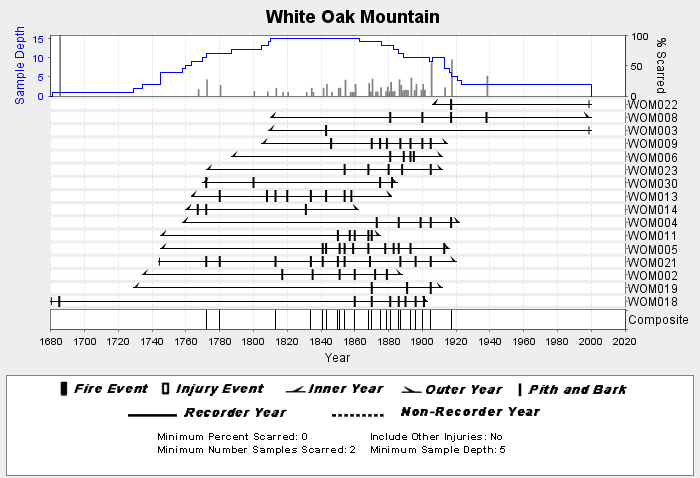
NOAA/WDS Paleoclimatology - Stambaugh fire data from White Oak Mountain - IMPD USWOM001
National Oceanic and Atmospheric Administration, Department of Commerce —
This archived Paleoclimatology Study is available from the NOAA National Centers for Environmental Information (NCEI), under the World Data Service (WDS) for... -
Federal
Bering-Okhotsk Seal Survey (BOSS) Color Imagery (2012-13)
National Oceanic and Atmospheric Administration, Department of Commerce —
US surveys were conducted of the Bering Sea pack ice for bearded, spotted, ribbon, and ringed seals using digital cameras and thermal imagers mounted in the belly... -
Federal
Temperature, salinity, dissolved oxygen measurements collected using CTD, bottle from multiple platforms in the Gulf of Mexico from 1992 through 2008 as part of the Southeast Area Monitoring and Assessment Program (SEAMAP) (NCEI Accession 0069702)
National Oceanic and Atmospheric Administration, Department of Commerce —
The Southeast Area Monitoring and Assessment Program (SEAMAP) is a State/Federal/university program for collection, management and dissemination of fishery-... -
Federal
Cetacean visual observations using line-transect survey methods onboard the NOAA Ship Gordon Gunter (GU) in the Gulf of Mexico, for the Vessel Surveys for Abundance and Distribution of Marine Mammals and Seabirds project (VSAD survey GU2303) from 2023-06-22 to 2023-08-14 (NCEI Accession 0290373)
National Oceanic and Atmospheric Administration, Department of Commerce —
As part of the Vessel Surveys for Abundance and Distribution of Marine Mammals and Seabirds (VSAD) project, the Southeast Fisheries Science Center (SEFSC) conducted a... -
Federal
Cetacean visual observations using line-transect survey methods onboard the NOAA Ship Gordon Gunter (GU) in the Gulf of Mexico (survey GU0402) from 2004-04-15 to 2004-06-10. (NCEI Accession 0284773)
National Oceanic and Atmospheric Administration, Department of Commerce —
The U.S. National Marine Fisheries Service (NMFS) is required to prepare an annual Stock Assessment Report (SAR) for each marine mammal stock to update abundance,... -
Federal
H13546: NOS Hydrographic Survey , 2022-06-01
National Oceanic and Atmospheric Administration, Department of Commerce —
The National Oceanic and Atmospheric Administration (NOAA) has the statutory mandate to collect hydrographic data in support of nautical chart compilation for safe... -
Federal
H13803: NOS Hydrographic Survey , 2023-06-01
National Oceanic and Atmospheric Administration, Department of Commerce —
The National Oceanic and Atmospheric Administration (NOAA) has the statutory mandate to collect hydrographic data in support of nautical chart compilation for safe... -
Federal
H13254: NOS Hydrographic Survey , 2019-09-09
National Oceanic and Atmospheric Administration, Department of Commerce —
The National Oceanic and Atmospheric Administration (NOAA) has the statutory mandate to collect hydrographic data in support of nautical chart compilation for safe... -
Federal
H13693: NOS Hydrographic Survey , 2023-08-13
National Oceanic and Atmospheric Administration, Department of Commerce —
The National Oceanic and Atmospheric Administration (NOAA) has the statutory mandate to collect hydrographic data in support of nautical chart compilation for safe... -
Federal
National Coral Reef Monitoring Program: Assessment of coral reef benthic communities in Flower Garden Banks National Marine Sanctuary from 2013-09-02 to 2013-09-06 and from 2015-08-24 to 2015-08-28 (NCEI Accession 0224589)
National Oceanic and Atmospheric Administration, Department of Commerce —
The National Coral Reef Monitoring Program (NCRMP) assessed coral reef communities in Flower Garden Banks National Marine Sanctuary (FGBNMS) in the Gulf of Mexico... -
Federal
Alaska Harbor Seal Glacial Surveys
National Oceanic and Atmospheric Administration, Department of Commerce —
Floating glacial ice serves as a haul-out substrate for a significant number (10-15%) of Alaskan harbor seals, and thus surveying tidewater glacial fjords is an... -
Federal
A Dataset of Aerial Survey Counts of Harbor Seals in Iliamna Lake, Alaska: 1984-2013
National Oceanic and Atmospheric Administration, Department of Commerce —
This dataset provides counts of harbor seals from aerial surveys over Iliamna Lake, Alaska, USA. The data have been collated from three previously published sources...

Official websites use .gov
A
.gov website belongs to an official government
organization in the United States.
Secure .gov websites use HTTPS
A
lock (
) or https:// means you’ve safely connected to
the .gov website. Share sensitive information only on official,
secure websites.