
-
Federal
MODIS/Terra Temperature and Water Vapor Profiles 5-Min L2 Swath 5km NGDA
National Aeronautics and Space Administration —
The MODIS/Terra Temperature and Water Vapor Profiles 5-Min L2 Swath 5km (MOD07_L2) product consists of a numbers of parameters related to atmospheric stability,... -
Federal
MODIS/Aqua Aerosol Cloud Water Vapor Ozone Daily L3 Global 1Deg CMG NGDA
National Aeronautics and Space Administration —
The MODIS/Aqua Aerosol Cloud Water Vapor Ozone Daily L3 Global 1Deg CMG product (MYD08_D3) contains daily 1 x 1 degree grid average values of atmospheric parameters... -
Federal
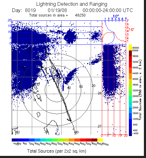
LIGHTNING DETECTION AND RANGING (LDAR) RAW DATA V1
National Aeronautics and Space Administration —
Lightning Detection and Ranging (LDAR) Raw data consists of level 1 lightning data collected from February 25, 1997 through June 11, 2008. The LDR system is located... -
Federal
Local Observations from the Seasonal Ice Zone Observing Network (SIZONet) and Alaska Arctic Observatory and Knowledge Hub (AAOKH), Version 2
National Aeronautics and Space Administration —
The Seasonal Ice Zone Observing Network (SIZONet) and the Alaska Arctic Observatory and Knowledge Hub (AAOKH) share the Local Observations Interface, which allows... -
Federal
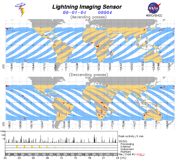
Lightning Imaging Sensor (LIS) on TRMM Science Data V4
National Aeronautics and Space Administration —
The Lightning Imaging Sensor (LIS) Science Data was collected by the LIS instrument on the Tropical Rainfall Measuring Mission (TRMM) satellite used to detect the... -
Federal
GPM GROUND VALIDATION CAMPAIGN REPORTS MC3E V1
National Aeronautics and Space Administration —
The GPM Ground Validation Campaign Reports MC3E dataset consists of various reports filed by the scientists during the Midlatitude Continental Convective Clouds... -
Federal
MODIS/Aqua Temperature and Water Vapor Profiles 5-Min L2 Swath 5km NGDA
National Aeronautics and Space Administration —
The MODIS/Aqua Temperature and Water Vapor Profiles 5-Min L2 Swath 5km (MYD07_L2) product consists of a numbers of parameters related to atmospheric stability,... -
Federal
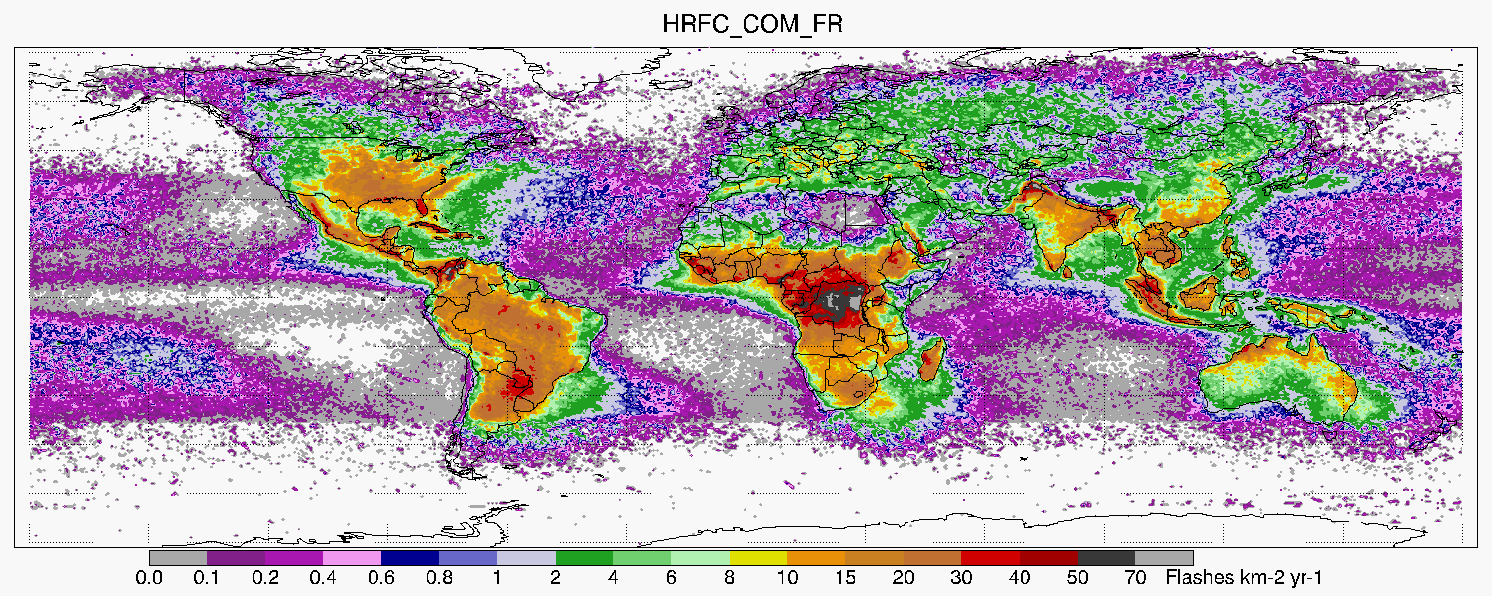
LIS/OTD 0.5 Degree High Resolution Full Climatology (HRFC) V2.3.2015
National Aeronautics and Space Administration —
The LIS/OTD 0.5 Degree High Resolution Full Climatology (HRFC) contains a variety of gridded climatologies of total lightning flash rates obtained from two lightning... -
Federal
HURRICANE AND SEVERE STORM SENTINEL (HS3) GLOBAL HAWK HIGH ALTITUDE MMIC SOUNDING RADIOMETER (HAMSR) V1
National Aeronautics and Space Administration —
The Hurricane and Severe Storm Sentinel (HS3) Global Hawk High Altitude MMIC Sounding Radiometer (HAMSR) dataset includes measurements gathered by the HAMSR... -
Federal
TCSP European Centre for Medium-Range Weather Forecasts (ECMWF) V1
National Aeronautics and Space Administration —
The TCSP European Centre for Medium-Range Weather Forecasts (ECMWF) dataset consists of three-hour forecast/analysis data for the Tropical Cloud Systems and Processes... -
Federal
Mission Reports IMPACTS V1
National Aeronautics and Space Administration —
The Mission Reports IMPACTS dataset consists of flight plans, plans of the day, science plans, and science summaries logged by scientists during the Investigation of... -
Federal
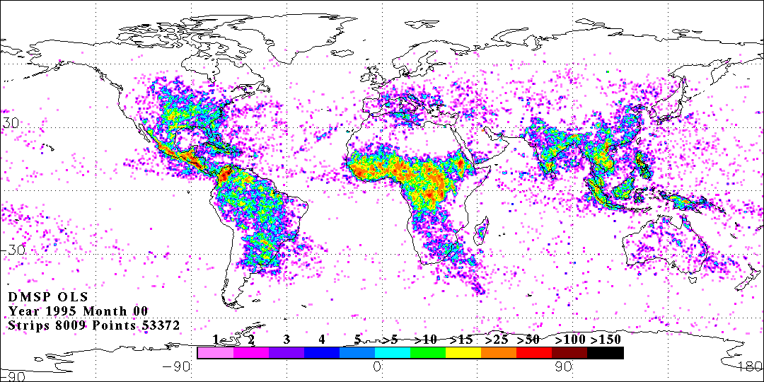
OLS DIGITAL DERIVED LIGHTNING FROM DMSP F12 V1
National Aeronautics and Space Administration —
The OLS Digital Derived Lightning from DMSP F12 dataset consists of global lightning signatures from the Defense Meteorological Satellite Program (DMSP) Operational... -
Federal
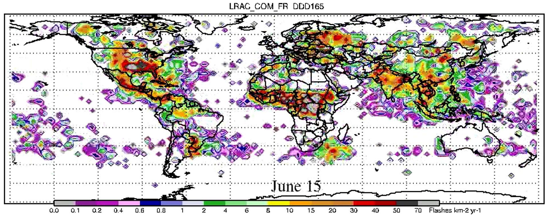
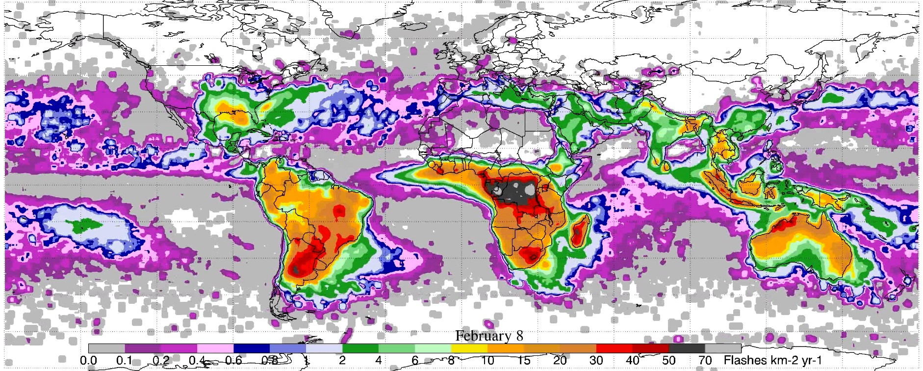
LIS/OTD 2.5 Degree Low Resolution Annual Climatology (LRAC) V2.3.2015
National Aeronautics and Space Administration —
The LIS/OTD 2.5 Degree Low Resolution Annual Climatology (LRAC) contains a variety of gridded climatologies of total lightning flash rates obtained from two lightning... -
Federal
LIS/OTD 0.5 Degree High Resolution Monthly Climatology (HRMC) V2.3.2015
National Aeronautics and Space Administration —
The LIS/OTD 0.5 Degree High Resolution Monthly Climatology (HRMC) contains a variety of gridded climatologies of total lightning flash rates obtained from two... -
Federal
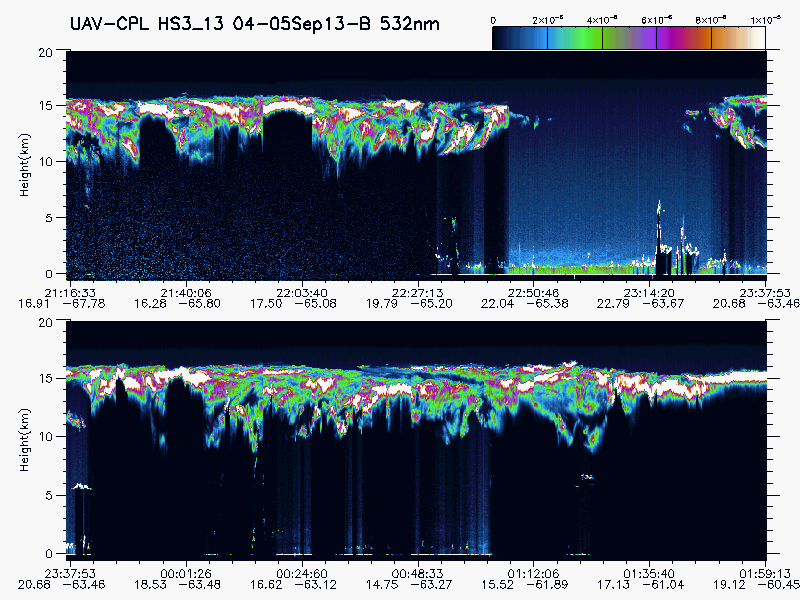
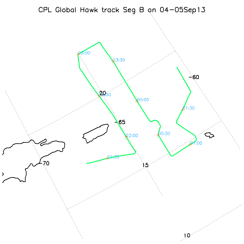
HURRICANE AND SEVERE STORM SENTINEL (HS3) GLOBAL HAWK CLOUD PHYSICS LIDAR (CPL) V1
National Aeronautics and Space Administration —
The Hurricane and Severe Storm Sentinel (HS3) Global Hawk Cloud Physics Lidar (CPL) dataset includes measurements gathered by the CPL instrument during the HS3... -
Federal
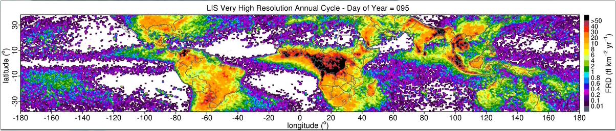
LIS 0.1 DEGREE VERY HIGH RESOLUTION GRIDDED LIGHTNING ANNUAL CLIMATOLOGY (VHRAC) V1
National Aeronautics and Space Administration —
The LIS 0.1 Degree Very High Resolution Gridded Lightning Annual Climatology (VHRAC) dataset consists of gridded annual climatologies of total lightning flash rates... -
Federal
Global 30-Year Mean Monthly Climatology, 1901-1960 (New et al.)
National Aeronautics and Space Administration —
A data set of 30-year mean monthly surface climate over global land areas, excluding Antarctica. Interpolated from station data to 0.5 degree lat/lon for a range of... -
Federal
GOES-R PLT Geostationary Coastal and Air Pollution Event (GEO-CAPE) Airborne Simulator (GCAS) V1
National Aeronautics and Space Administration —
The GOES-R PLT Geostationary Coastal and Air Pollution Event (GEO-CAPE) Airborne Simulator (GCAS) dataset consist of solar backscattered radiation measured by the...

Official websites use .gov
A
.gov website belongs to an official government
organization in the United States.
Secure .gov websites use HTTPS
A
lock (
) or https:// means you’ve safely connected to
the .gov website. Share sensitive information only on official,
secure websites.