
-
Federal
SMAPVEX19-22 Massachusetts Vegetation Optical Depth V001
National Aeronautics and Space Administration —
As part of the SMAPVEX19-22 campaign, an L-band radiometer was deployed on top of a tower at Harvard Forest,Massachusetts, looking down at a stand of red oak forest.... -
Federal
CERES Single Scanner Footprint (SSF) TOA/Surface Fluxes, Clouds and Aerosols NPP-FM5 Edition2A
National Aeronautics and Space Administration —
CER_SSF_NPP-FM5_Edition2A data are CERES observed TOA fluxes, MODIS clouds and aerosols, and parameterized surface fluxes.The Single Scanner Footprint TOA/Surface... -
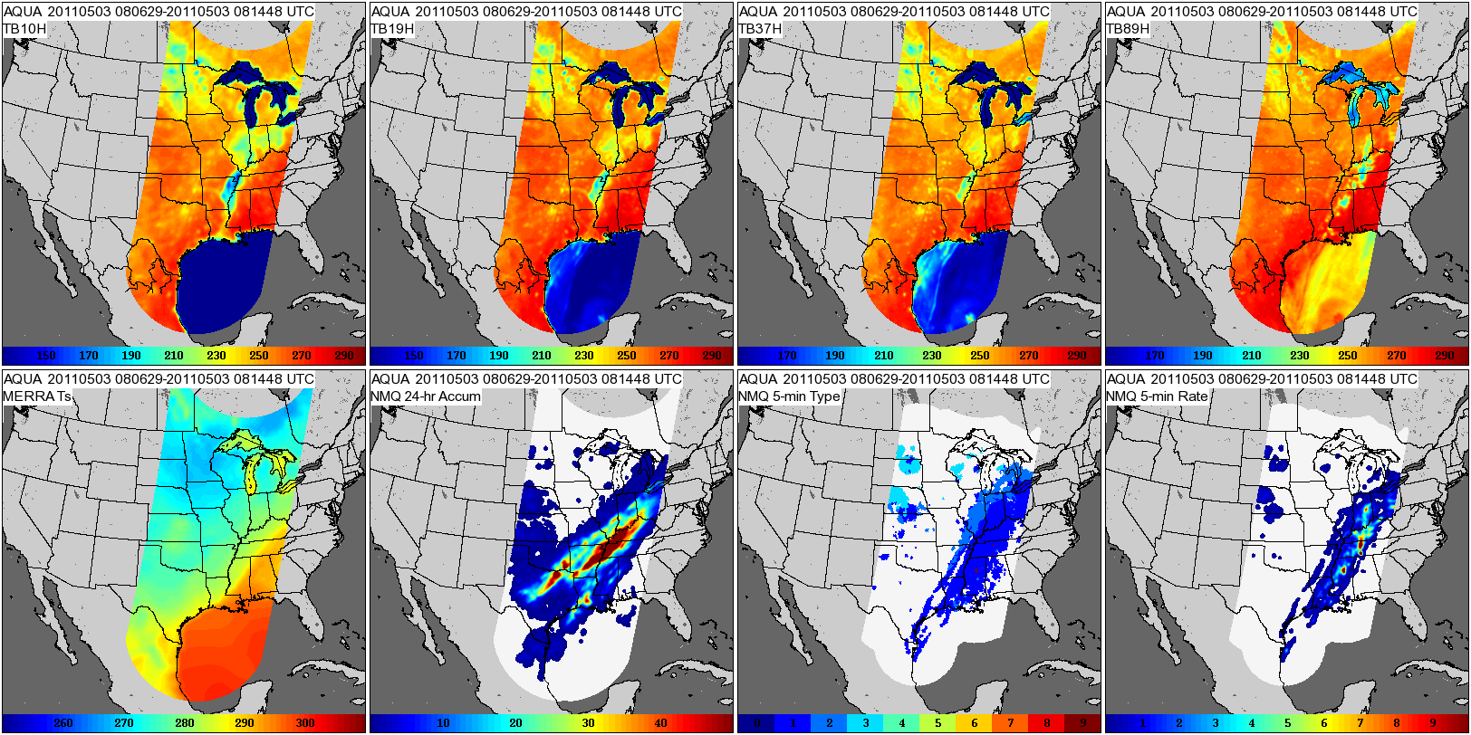
Federal
GPM GROUND VALIDATION COMPOSITE SATELLITE OVERPASSES MC3E V1
National Aeronautics and Space Administration —
The GPM Ground Validation Composite Satellite Overpasses MC3E dataset provides satellite overpasses from the AQUA satellite during the Midlatitude Continental... -
Federal
GPM GROUND VALIDATION SATELLITE SIMULATED ORBITS MC3E V1
National Aeronautics and Space Administration —
The GPM Ground Validation Satellite Simulated Orbits MC3E dataset is available in the Orbital database , which takes account for the atmospheric profiles, the... -
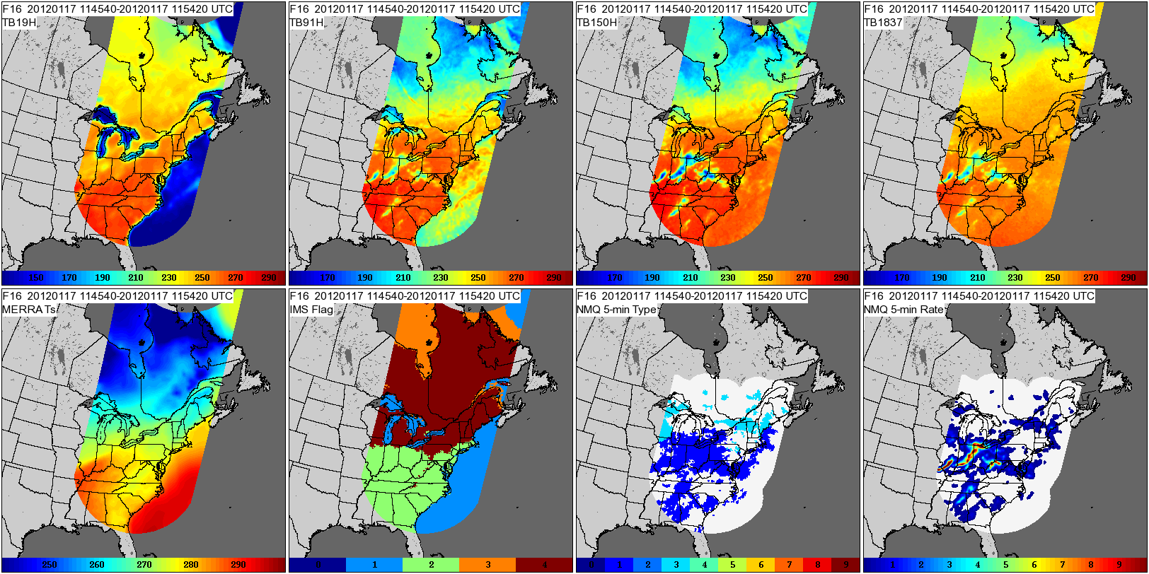
Federal
GPM GROUND VALIDATION COMPOSITE SATELLITE OVERPASSES GCPEX V1
National Aeronautics and Space Administration —
The GPM Ground Validation Composite Satellite Overpasses GCPEx dataset provides satellite overpasses from the Special Sensor Microwave Imager/Sounder (SSMIS)... -
Federal
CERES Clouds and Radiative Swath Terra FM1 MODIS Edition2G
National Aeronautics and Space Administration —
CER_CRS_Terra-FM1-MODIS_Edition2G is the Clouds and the Earth's Radiant Energy System (CERES) Clouds and Radiative Swath (CRS) Terra Flight Model 1 (FM1) Moderate-... -
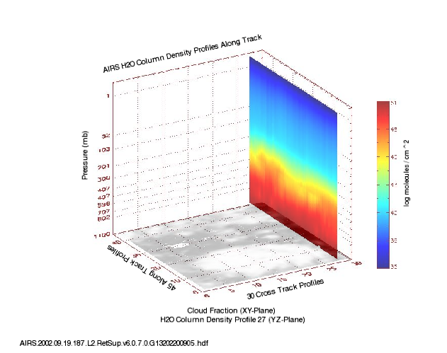
Federal
AIRS/Aqua L2 Support Retrieval (AIRS+AMSU) V006 (AIRX2SUP) at GES DISC
National Aeronautics and Space Administration —
The Atmospheric Infrared Sounder (AIRS) is a grating spectrometer (R = 1200) aboard the second Earth Observing System (EOS) polar-orbiting platform, EOS Aqua. In... -
Federal
ACTIVATE Merged MODIS and MERRA-2 Dataset NGDA
National Aeronautics and Space Administration —
ACTIVATE-MODIS-MERRA2 is the merged CERES MODIS and MERRA-2 dataset (pixel-level geostationary cloud products) produced by SatCORPS group at NASA Langley Research... -
Federal
TOVS GLA 5 DAY GRIDS from NOAA-9 V01 (TOVSA5NF) at GES DISC
National Aeronautics and Space Administration —
This dataset (TOVSA5NF) contains the TIROS Operational Vertical Sounder (TOVS) level 3 geophysical parameters derived using data from NOAA-9 and the physical... -
Federal
CERES MODIS Cloud Retrievals in ISCCP-D2like Format Nighttime Aqua FM4 Edition3A NGDA
National Aeronautics and Space Administration —
CER_ISCCP-D2like-Nit_Aqua-FM4-MODIS_Edition3A is the Clouds and the Earth's Radiant Energy System (CERES) Moderate Resolution Imaging Spectroradiometer (MODIS) Cloud... -
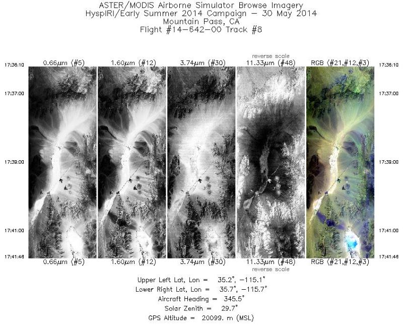
Federal
MASTER: HyspIRI Airborne Campaign, California, Late Spring 2014
National Aeronautics and Space Administration —
This dataset includes Level 1B (L1B) and Level 2 (L2) data products from the MODIS/ASTER Airborne Simulator (MASTER) instrument. The spectral data were collected as... -
Federal
NOAA-14 AVHRR Top-of-Atmosphere Reflectance Daily L3 Global 0.05 Deg. CMG
National Aeronautics and Space Administration —
The Long-Term Data Record (LTDR) produces, validates, and distributes a global land surface climate data record (CDR) that uses both mature and well-tested algorithms... -
Federal
CERES Single Scanner Footprint (SSF) TOA/Surface Fluxes, Clouds and Aerosols NOAA20-FM6-VIIRS Edition1B
National Aeronautics and Space Administration —
CER_SSF_NOAA20-FM6_Edition1B data are Clouds and the Earth's Radiant Energy System (CERES) observed Top of Atmosphere (TOA) fluxes, Moderate Resolution Imaging... -
Federal
BOREAS HYD-02 Estimated Snow Water Equivalent (SWE) from Microwave Measurements
National Aeronautics and Space Administration —
Contains HYD-02 snow water equivalent derived from microwave measurements from aircraft. -
Federal
Reduced Resolution Geolocated and Calibrated TOA Radiance
National Aeronautics and Space Administration —
The Medium Resolution Imaging Spectrometer (MERIS) is one of 10 sensors deployed in March of 2002 on board the polar-orbiting Envisat-1 environmental research... -
Federal
GPM GROUND VALIDATION SATELLITE SIMULATED ORBITS C3VP V1
National Aeronautics and Space Administration —
The GPM Ground Validation Satellite Simulated Orbits C3VP dataset is available in the Orbital database, which takes account for the atmospheric profiles, the... -
Federal
CLPX-Ground: Ground-Based Infrared Images of the LSOS Site, Version 1
National Aeronautics and Space Administration —
This data set presents more than 400 sub-canopy digital thermograms collected at the Fraser Experimental Forest (Fraser, Colorado, USA) using an Infrared Solutions IR... -
Federal
SnowEx Meteorological Station Measurements from Grand Mesa, CO Raw V001
National Aeronautics and Space Administration —
This dataset contains raw meteorological data collected as part of the ongoing the NASA SnowEx mission, from five meteorological stations installed between 2016-2017... -
Federal
CERES Monthly Gridded Radiative Fluxes and Clouds Terra FM1 Edition2F
National Aeronautics and Space Administration —
CER_FSW_Terra-FM1-MODIS_Edition2F is the Clouds and the Earth's Radiant Energy System (CERES) Monthly Gridded Radiative Fluxes and Clouds Terra Flight Model 1 (FM1)... -
Federal
NOAA-07 AVHRR Top-of-Atmosphere Reflectance Daily L3 Global 0.05 Deg. CMG
National Aeronautics and Space Administration —
The Long-Term Data Record (LTDR) produces, validates, and distributes a global land surface climate data record (CDR) that uses both mature and well-tested algorithms...

Official websites use .gov
A
.gov website belongs to an official government
organization in the United States.
Secure .gov websites use HTTPS
A
lock (
) or https:// means you’ve safely connected to
the .gov website. Share sensitive information only on official,
secure websites.