
-
Federal
NACP North American Forest Dynamics Project: Forest Disturbance and Regrowth Data
National Aeronautics and Space Administration —
This data set provides the results of time-series analyses of Landsat imagery for 55 selected forested sites across the conterminous U.S.A. The output is a pair of... -
Federal
LIMS/Nimbus-7 Level 1 Radiance Data V001 (LIMSN7L1PROFILER) at GES DISC
National Aeronautics and Space Administration —
LIMSN7L1PROFILER is the Nimbus-7 Limb Infrared Monitor of the Stratosphere (LIMS) Level-1 Profiles of Radiance Data product and contains selected daily vertical... -
Federal
High Resolution Empirical Tide Prediction Software Version 14
National Aeronautics and Space Administration —
This dataset provides sea surface height and ocean surface currents associated with the predictable astronomical tide at the M2, S2, N2, K1, and O1 frequencies. The... -
Federal
Real System Failures
National Aeronautics and Space Administration —
This resource area contains descriptions of actual electronic systems failure scenarios with an emphasis on the diversity of failure modes and effects that can befall... -
Federal
GOES-R PLT Lightning Instrument Package (LIP) V1
National Aeronautics and Space Administration —
The GOES-R PLT Lightning Instrument Package (LIP) dataset consists of electrical field measurements of lightning and navigation data collected by the Lightning... -
Federal
EMIT L2B Estimated Mineral Identification and Band Depth and Uncertainty 60 m V001
National Aeronautics and Space Administration —
The Earth Surface Mineral Dust Source Investigation (EMIT) instrument measures surface mineralogy, targeting the Earth’s arid dust source regions. EMIT is installed... -
Federal
Northern and Mid-Latitude Soil Database, Version 1, R1
National Aeronautics and Space Administration —
The U.S. Department of Agriculture, Agriculture and Agri-Food Canada, the Russian Academy of Agricultural Sciences, the University of Copenhagen Institute of... -
Federal
Delta-X: Delft3D Sediment Model, Site 322, Terrebonne Basin, MRD, Louisiana, USA
National Aeronautics and Space Administration —
This dataset contains the Delft3D model of the intensive site 322 in the Terrebonne Basin along the Mississippi River Delta (MRD) in coastal Louisiana. Simulations... -
Federal
ABoVE: High Resolution Cloud-Free Snow Cover Extent and Snow Depth, Alaska, 2001-2017
National Aeronautics and Space Administration —
This dataset provides estimates of maximum snow cover extent (SCE) and snow depth for each 8-day composite period from 2001 to 2017 at 1 km resolution across Alaska.... -
Federal
Sounder SIPS: AQUA AIRS IR MW Level 3 CLIMCAPS : Specific Quality Control Gridded Daily V2 at GES DISC
National Aeronautics and Space Administration —
WARNING: Users of the derived product “co_mmr_midtrop” (carbon monoxide mass mixing ratio to dry air [kg/kg] at ~500 hPa). This variable has a significant bias due to... -
Federal
Global 1-km Gridded Thickness of Soil, Regolith, and Sedimentary Deposit Layers
National Aeronautics and Space Administration —
This data set provides high-resolution estimates of the thickness of the permeable layers above bedrock (soil, regolith, and sedimentary deposits) within a global... -
Federal
JPSS-2 CrIS Level 1B Beta Full Spectral Resolution V3 (SNDRJ2CrISL1B) at GES DISC
National Aeronautics and Space Administration —
The goal of creating this product is to allow users to begin working with data from the CrIS instrument on-board the recently launched NOAA-21 / JPSS-2 (J2)... -
Federal
Sentinel-5P TROPOMI Near-Real-Time (NRT) Sulphur Dioxide SO2 1-Orbit L2 5.5km x 3.5km V2 (S5P_L2__SO2____HiR_NRT) at GES DISC
National Aeronautics and Space Administration —
The Sentinel-5P TROPOMI Near Real Time (NRT) Sulphur Dioxide SO2 1-Orbit L2 5.5km x 3.5km V2 (S5P_L2__SO2_HiRNRT) at GES DISC is the near real time version of the... -
Federal
Sentinel-6A Level 1B GNSS Radio Occultation Daily RINEX V1 (S6A_RO_1B_POD_RNX_) at GES DISC
National Aeronautics and Space Administration —
This dataset provides the L1B Global Navigation Satellite System (GNSS) Radio Occultation (RO) Precise Orbit Determination (POD) data generated by NASA JPL from... -
Federal
CERES and GEO-Enhanced TOA, Within-Atmosphere and Surface Fluxes, Clouds and Aerosols 1-Hourly Terra-Aqua-NOAA20 Edition4B
National Aeronautics and Space Administration —
CER_SYN1deg-1Hour_Terra-Aqua-NOAA20_Edition4B is the Clouds and the Earth's Radiant Energy System (CERES) and geostationary (GEO) Top-of-Atmosphere (TOA) Within-... -
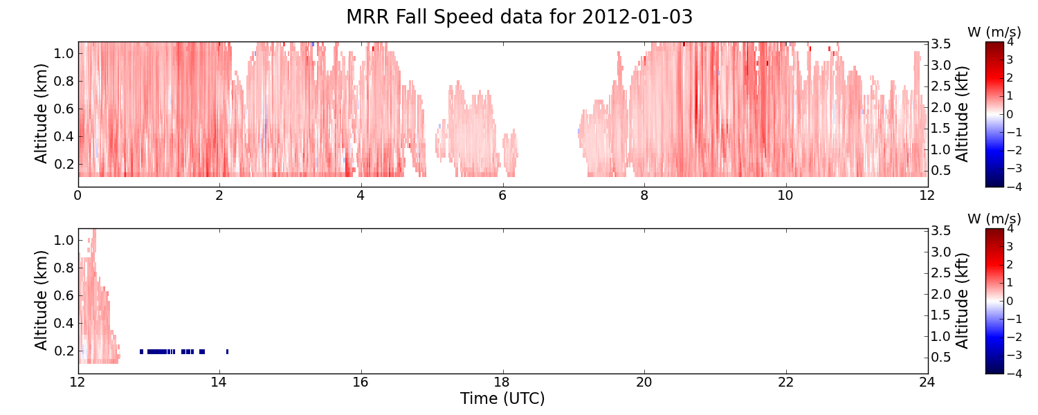
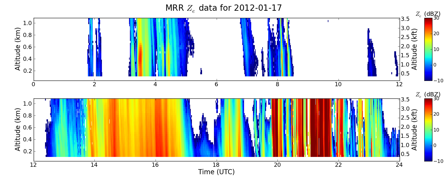
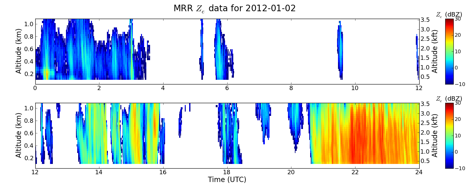
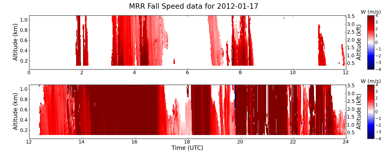
Federal
GPM GROUND VALIDATION ENVIRONMENT CANADA (EC) MICRO RAIN RADAR (MRR) GCPEX V2
National Aeronautics and Space Administration —
The GPM Ground Validation Environment Canada (EC) Micro Rain Radar (MRR) GCPEx V2 dataset was collected from the Micro Rain Radar (MRR) during the GPM Cold-season... -
Federal
SNPP VIIRS High Resolution Level 3 monthly aerosol data, 0.1x0.1 degree grid Version 001 (AER_DBDT_M10KM_L3_VIIRS_SNPP) at GES DISC
National Aeronautics and Space Administration —
This High-Resolution (0.1 x 0.1 degree) Level 3 monthly Aerosol Optical Depth (AOD) product is generated by combining two Visible Infrared Imaging Radiometer Suite... -
Federal
GPM GROUND VALIDATION DUAL-FREQUENCY DUAL-POLARIZED DOPPLER RADAR (D3R) GCPEX V1
National Aeronautics and Space Administration —
The GPM Ground Validation Dual-frequency Dual-polarized Doppler Radar (D3R) GCPEx and IFloodS data sets contain radar reflectivity and doppler velocity measurements.... -
Federal
BUV/Nimbus-4 Level 2 High-Density Ozone Data V005 (BUVN4L2HDBUV) at GES DISC
National Aeronautics and Space Administration —
The Nimbus-4 BUV Level 2 High-Density Ozone Data collection contains the vertical distribtuion and total column amount of ozone, as well as the full set of ancillary...

Official websites use .gov
A
.gov website belongs to an official government
organization in the United States.
Secure .gov websites use HTTPS
A
lock (
) or https:// means you’ve safely connected to
the .gov website. Share sensitive information only on official,
secure websites.