
-
Federal
SAFARI 2000 Carbon in Live Vegetation, 0.5-Deg (Olson)
National Aeronautics and Space Administration —
This data set is a subset of Olson's Major World Ecosystem Complexes for southern Africa in ASCII GRID and binary image files formats. Olson's Major World Ecosystem... -
Federal
NPP Tropical Forest: Gunung Mulu, Malaysia, 1977-1978, R1
National Aeronautics and Space Administration —
This data set contains seven ASCII data files (.txt format). Four files provide NPP data for contrasting lowland rainforests within Gunung Mulu National Park on the... -
Federal
SAFARI 2000 Woody Vegetation Characteristics of Kalahari and Skukuza Sites
National Aeronautics and Space Administration —
This data set contains species composition, basal area, height, and crown cover of all woody plants at six sites along the Kalahari Transect visited in February-March... -
Federal
In-situ Air Temperature and Relative Humidity in Greenbelt, MD, 2013-2015
National Aeronautics and Space Administration —
This data set describes the temperature and relative humidity at 12 locations around Goddard Space Flight Center in Greenbelt MD at 15 minute intervals between... -
Federal
AfriSAR: Aboveground Biomass for Lope, Mabounie, Mondah, and Rabi Sites, Gabon
National Aeronautics and Space Administration —
This dataset provides gridded estimates of aboveground biomass (AGB) for four sites in Gabon at 0.25 ha (50 m) resolution derived with field measurements and airborne... -
Federal
SAFARI 2000 Landscape Photographs of Kalahari Transect, Mongu, Skukuza Sites
National Aeronautics and Space Administration —
This data set contains Global Positioning System (GPS) imprinted landscape photographs at 100 m intervals along the Large Grid Transects at Kalahari Transect sites in... -
Federal
Landsat-based Phenology and Tree Ring Characterization, Eastern US Forests, 1984-2013
National Aeronautics and Space Administration —
This data set provides a 30-year record of Landsat TM and ETM+ derived forest phenology and the results of tree ring analyses for annual wood production and nitrogen... -
Federal
BOREAS TGB-07 Ambient Air Herbicide and Organochlorine Concentration Data
National Aeronautics and Space Administration —
The BOREAS TGB-07 team measured the concentration and flux of several agricultural pesticides in air, rainwater, and dry deposition samples in order to determine the... -
Federal
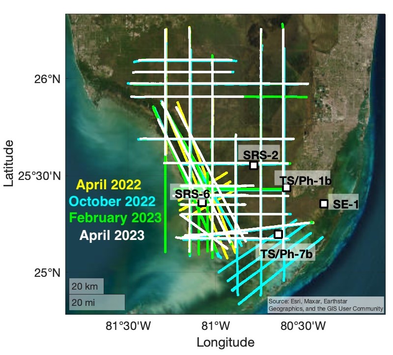
BlueFlux Airborne Trace Gases, Fluxes, and Mixing Ratios, Southern Florida, 2022-2023
National Aeronautics and Space Administration —
This dataset includes airborne in situ measurements of greenhouse gas mixing ratios, meteorological parameters, and fluxes (CO2, CH4, latent heat fluxes, friction... -
Federal
SAFARI 2000 Historical Fire Maps, Kruger National Park, 1992-2001
National Aeronautics and Space Administration —
Kruger National Park (KNP) was established in 1898 to protect wildlife on nearly 2 million hectares of the South African Lowveld. The climate in this region of South... -
Federal
SAFARI 2000 Meteorological Tower Measurements, Kruger National Park, 2000-2002
National Aeronautics and Space Administration —
An eddy covariance system mounted on a tower near the Skukuza Camp in Kruger National Park, South Africa, has been operating continuously since early 2000.... -
Federal
SAFARI 2000 ALI/ETM+ Tandem Image Pair for Skukuza, South Africa, May 2001
National Aeronautics and Space Administration —
A tandem pair of Advanced Land Imager (ALI) and Landsat Enhanced Thematic Mapper Plus (ETM+) scenes covering the same part of Kruger National Park (KNP), South Africa... -
Federal
SAFARI 2000 BRDF Measurements at Sua Pan and Skukuza, Dry Season 2000
National Aeronautics and Space Administration —
The Jet Propulsion Laboratory's (JPL) Portable Apparatus for Rapid Acquisition of Bidirectional Observation of the Land and Atmosphere (PARABOLA), version III,... -
Federal
SAFARI 2000 Biomass Burning Emissions, Selected Sites, Dry Season 2000
National Aeronautics and Space Administration —
Biomass burning is a major source for gaseous and particulate atmospheric pollution over southern Africa and globally. The purpose of this study was to quantify... -
Federal
SAFARI 2000 AERONET-derived Diffuse Spectral Irradiance for Eight Core Sites
National Aeronautics and Space Administration —
This data set contains monthly mean values of diffuse irradiance fraction [f(Ediff), or ratio of diffuse-to-total irradiance] at ground level for a 30-degree solar... -
Federal
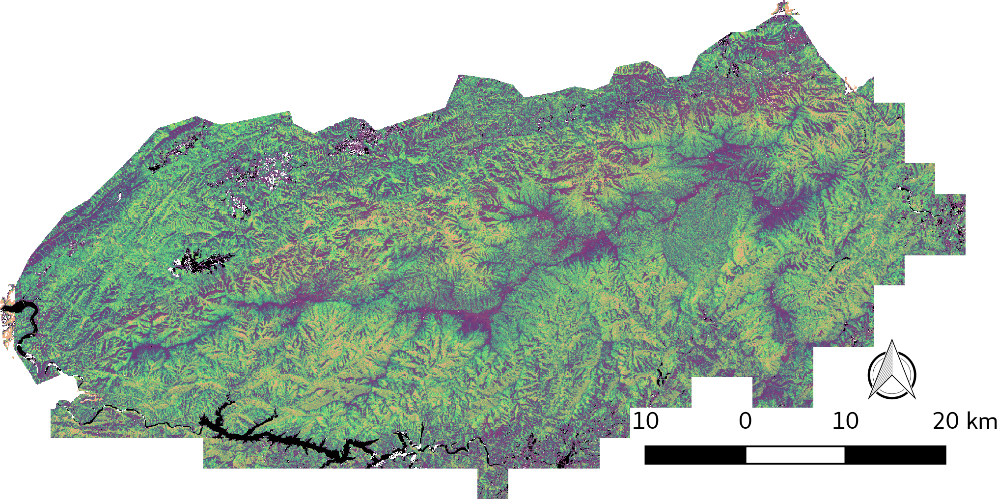
LiDAR-derived Vegetation Canopy Structure, Great Smoky Mountains National Park, 2011
National Aeronautics and Space Administration —
This dataset provides multiple-return LiDAR-derived vegetation canopy structure at 30-meter spatial resolution for the Great Smoky Mountains National Park (GSMNP).... -
Federal
LBA-ECO LC-19 Soil and Vegetation Data for Cerrado and Forested Sites, Brazil: 2002
National Aeronautics and Space Administration —
This data set provides measurements for soil physical and chemical properties, rooting depth and weight, leaf area index (LAI), plant area index (PAI), biomass,... -
Federal
LBA-ECO LC-01 National, Provincial, and Park Boundaries, Ecuador
National Aeronautics and Space Administration —
This data set contains the national and provincial boundaries of Ecuador as well as the boundaries of two national parks: the Cuyabeno Wildlife Reserve and the Yasuni... -
Federal
BOREAS Prince Albert National Park Forest Cover Data in Vector Format
National Aeronautics and Space Administration —
This data set provides detailed canopy, understory, and ground cover, height, density, and condition information for PANP in the western portion of the BOREAS SSA in...

Official websites use .gov
A
.gov website belongs to an official government
organization in the United States.
Secure .gov websites use HTTPS
A
lock (
) or https:// means you’ve safely connected to
the .gov website. Share sensitive information only on official,
secure websites.