
-
Federal
CYGNSS Level 1 Science Data Record Version 3.2
National Aeronautics and Space Administration —
This CYGNSS Level 1 (L1) science data record dataset contains the version 3.2 geo-located Delay Doppler Maps (DDMs) calibrated into Power Received (Watts) and... -
Federal
CYGNSS L3 Ocean Microplastic Concentration V1.0
National Aeronautics and Space Administration —
This dataset contains the version 1.0 CYGNSS level 3 ocean microplastic concentration data record, which provides 18 netCDF files, each containing one month of daily... -
Federal
HIRENASD Beam FEM
National Aeronautics and Space Administration —
This contains attempts to create BEAM FEM model. I have started a Blog to discuss this... please put your comments there and I will attempt to keep everything... -
Federal
CYGNSS Level 1 Climate Data Record Version 1.0
National Aeronautics and Space Administration —
This Level 1 (L1) dataset contains the Version 1.0 Climate Data Record (CDR) of the geo-located Delay Doppler Maps (DDMs) calibrated into Power Received (Watts) and... -
Federal
SARP 2022 Data
National Aeronautics and Space Administration —
SARP_2022_Data is the data collected onboard the NASA DC-8 aircraft and using ozonesondes during the 2022 deployment of the Student Airborne Research Program (SARP)... -
Federal
CYGNSS Level 3 Storm Centric Grid Science Data Record Version 1.0
National Aeronautics and Space Administration —
This dataset contains the Version 1.0 Cyclone Global Navigation Satellite System (CYGNSS) Level 3 Storm Centric Grid (SCG) Science Data Record (SDR) which provides... -
Federal
TIROS-4 Medium-Resolution Scanning Radiometer Level 1 Final Meteorological Radiation Data V001 (TIROS4L1FMRT) at GES DISC
National Aeronautics and Space Administration —
TIROS-4 Medium-Resolution Scanning Radiometer Level 1 Final Meteorological Radiation Data (FMRT) product contains radiances expressed in five infrared/visible... -
Federal
TIROS-2 Medium-Resolution Scanning Radiometer Level 1 Final Meteorological Radiation Data V001 (TIROS2L1FMRT) at GES DISC
National Aeronautics and Space Administration —
TIROS-2 Medium-Resolution Scanning Radiometer Level 1 Final Meteorological Radiation Data (FMRT) product contains radiances expressed in five infrared/visible... -
Federal
THIR/Nimbus-4 Level 1 Meteorological Radiation Data at 11.5 microns V001 (THIRN4L1CH115) at GES DISC
National Aeronautics and Space Administration —
THIRN4L1CH115 is the Nimbus-4 Temperature-Humidity Infrared Radiometer (THIR) Level 1 Meteorological Radiation Data at 11.5 microns product and contains radiances... -
Federal
BUV/Nimbus-4 Level 2 Compressed Ozone Profile Data V005 (BUVN4L2CPOZ) at GES DISC
National Aeronautics and Space Administration —
The Nimbus-4 BUV Level 2 Compressed Ozone Profile Data collection or CPOZ contains total ozone, reflectivities, ozone mixing ratios and layer ozone amounts measured... -
Federal
CYGNSS Level 3 Ocean Microplastic Concentration Version 3.2
National Aeronautics and Space Administration —
The CYGNSS L3 Ocean Microplastic Concentration V3.2 dataset is provided by the CYGNSS Science Team of the University of Michigan.CYGNSS was launched on 15 December... -
Federal
CYGNSS Level 3 Climate Data Record Version 1.0
National Aeronautics and Space Administration —
This dataset contains the Version 1.0 CYGNSS Level 3 Climate Data Record which provides the average wind speed and mean square slope (MSS) on a 0.2x0.2 degree... -
Federal
BUV/Nimbus-4 Level 2 High-Density Ozone Data V005 (BUVN4L2HDBUV) at GES DISC
National Aeronautics and Space Administration —
The Nimbus-4 BUV Level 2 High-Density Ozone Data collection contains the vertical distribtuion and total column amount of ozone, as well as the full set of ancillary... -
Federal
NEMS/Nimbus-5 Level 2 Output Data V001 (NEMSN5L2) at GES DISC
National Aeronautics and Space Administration —
NEMSN5L2 is the Nimbus-5 or Nimbus-E Microwave Spectrometer (NEMS) Level-2 Output Data product and contains surface reflectivity, water vapor, liquid water, layer... -
Federal
TIROS-4 Low-Resolution Omnidirectional Radiometer Level 1 Radiance Data V001 (TIROS4L1ORR) at GES DISC
National Aeronautics and Space Administration —
The TIROS-4 Low-Resolution Omnidirectional Radiometer Level 1 Radiance Data product contains the longwave radiation values in Langleys/min derived from the black and... -
Federal
BUV/Nimbus-4 Dark Current Study Master Data V001 (BUVN4L1DCM) at GES DISC
National Aeronautics and Space Administration —
The Nimbus-4 BUV Level-1 Dark Current Study Master Data is derived from the BUV Level 1 Radiance (RUT) product and contains the geophysical indices and... -
Federal
SAFARI 2000 Land Cover from AVHRR, 8-km, 1984 (DeFries et al.)
National Aeronautics and Space Administration —
This data set consists of a southern African subset of the University of Maryland (UMD) 8-km Global Land Cover product in ASCII GRID and binary image files formats.... -
Federal
SARP 2017 Data
National Aeronautics and Space Administration —
SARP_2017_Data is the data collected onboard the Wallops C-23 aircraft during the 2017 deployment of the Student Airborne Research Program (SARP) mission. Data... -
Federal
CYGNSS Level 2 Climate Data Record Version 1.0
National Aeronautics and Space Administration —
This dataset contains the Version 1.0 CYGNSS Level 2 Climate Data Record which provides the time-tagged and geolocated average wind speed (m/s) and mean square slope... -
Federal
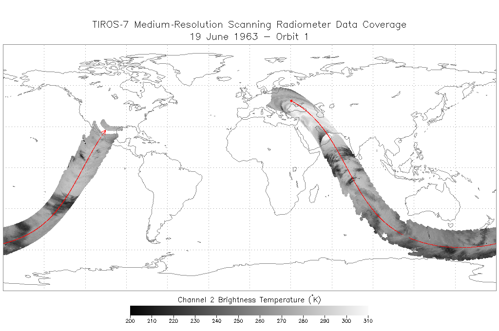
TIROS-7 Medium-Resolution Scanning Radiometer Level 1 Final Meteorological Radiation Data V001 (TIROS7L1FMRT) at GES DISC
National Aeronautics and Space Administration —
TIROS-7 Medium-Resolution Scanning Radiometer Level 1 Final Meteorological Radiation Data (FMRT) product contains radiances expressed in five infrared/visible...

Official websites use .gov
A
.gov website belongs to an official government
organization in the United States.
Secure .gov websites use HTTPS
A
lock (
) or https:// means you’ve safely connected to
the .gov website. Share sensitive information only on official,
secure websites.