
-
Federal
BOUSSOLE project
National Aeronautics and Space Administration —
The purpose of the BOUSSOLE project is to establish a time series of optical properties in oceanic waters, in support to bio-optics research, to calibration of ocean... -
Federal
Global Gridded Soil Phosphorus Distribution Maps at 0.5-degree Resolution
National Aeronautics and Space Administration —
This data set provides estimates of different forms of naturally occurring soil phosphorus (P) including labile inorganic P, organic P, occluded P, secondary mineral... -
Federal
PEM Tropics B P-3B In-Situ Aerosol Data
National Aeronautics and Space Administration —
PEM-Tropics-B_Aerosol_AircraftInSitu_P3B_Data is the in-situ aerosol data collected onboard the P-3B aircraft during the Pacific Exploratory Mission (PEM) Tropics B... -
Federal
A Global Database of Gas Fluxes from Soils after Rewetting or Thawing, Version 1.0
National Aeronautics and Space Administration —
This database contains information compiled from published studies on gas flux from soil following rewetting or thawing. The resulting database includes 222 field and... -
Federal
HAQAST Sentinel-5P TROPOMI Nitrogen Dioxide (NO2) GLOBAL Monthly Level 3 0.1 x 0.1 Degree Gridded Data Version 2.4 (HAQ_TROPOMI_NO2_GLOBAL_M_L3) at GES DISC
National Aeronautics and Space Administration —
This product provides level 3 monthly averages of tropospheric Nitrogen dioxide (NO2) vertical column density derived from the level 2 Tropospheric Monitoring... -
Federal
Merged Sentinel-3A and Sentinel-3B OLCI Global Binned CyAN Project, True Color (TC) Data, version 5.0
National Aeronautics and Space Administration —
Cyanobacteria Assessment Network (CyAN) is a multi-agency project among EPA, the National Aeronautics and Space Administration (NASA), the National Oceanic and... -
Federal
LISTOS New Haven Ground Site Data
National Aeronautics and Space Administration —
LISTOS_Ground_NewHaven_Data is the Long Island Sound Tropospheric Ozone Study (LISTOS) ground site data collected at the New Haven ground site during the LISTOS field... -
Federal
Alpha Jet Atmospheric eXperiment Ozone Data
National Aeronautics and Space Administration —
The Alpha Jet Atmospheric eXperiment (AJAX) is a partnership between NASA's Ames Research Center and H211, L.L.C., facilitating routine in-situ measurements over... -
Federal
SBUV2/NOAA-18 Ozone (O3) Profile and Total Column Ozone 1 Month Zonal Mean L3 Global 5.0 degree Latitude Zones V1 (SBUV2N18L3zm) at GES DISC
National Aeronautics and Space Administration —
The Solar Backscattered Ultraviolet (SBUV) from NOAA-18 Level-3 monthly zonal mean (MZM) product (SBUV2N18L3zm) is derived from the Level-2 retrieved ozone profiles.... -
Federal
ACCLIP WB-57 Aircraft Merge Data
National Aeronautics and Space Administration —
ACCLIP_Merge_WB57-Aircraft_Data is the pre-generated merge files created from a variety of in-situ instrumentation collecting measurements onboard the WB-57 aircraft... -
Federal
GEOS-Carb CASA-GFED Daily Fire and Fuel Emissions 0.5 degree x 0.5 degree V3 (GEOS_CASAGFED_D_FIRE) at GES DISC
National Aeronautics and Space Administration —
This product provides Daily average wildfire emissions (FIRE) andfuel wood burning emissions (FUEL) derived from the Carnegie-Ames-Stanford-Approach – Global Fire... -
Federal
MERRA-2 tavgU_2d_aer_Nx: 2d,diurnal,Time-averaged,Single-Level,Assimilation,Aerosol Diagnostics 0.625 x 0.5 degree V5.12.4 (M2TUNXAER) at GES DISC
National Aeronautics and Space Administration —
M2TUNXAER (or tavgU_2d_aer_Nx) is a time-averaged 2-dimensional monthly diurnal means data collection in Modern-Era Retrospective analysis for Research and... -
Federal
ATom: Merged Atmospheric Chemistry, Trace Gases, and Aerosols, Version 2
National Aeronautics and Space Administration —
This dataset provides information on greenhouse gases and human-produced air pollution, including atmospheric concentrations of carbon dioxide (CO2), methane (CH4),... -
Federal
MLS/Aura Level 3 Daily Binned Methyl Chloride (CH3Cl) Mixing Ratio on Assorted Grids V004 (ML3DBCH3CL) at GES DISC
National Aeronautics and Space Administration —
ML3DBCH3CL is the EOS Aura Microwave Limb Sounder (MLS) daily binned on various vertical grids product for methyl chloride (CH3Cl) derived from radiances measured by... -
Federal
SARP 2021 Data
National Aeronautics and Space Administration —
SARP_2021_Data is the data collected onboard the NASA DC-8 aircraft during the 2021 deployment of the Student Airborne Research Program (SARP) mission. Data... -
Federal
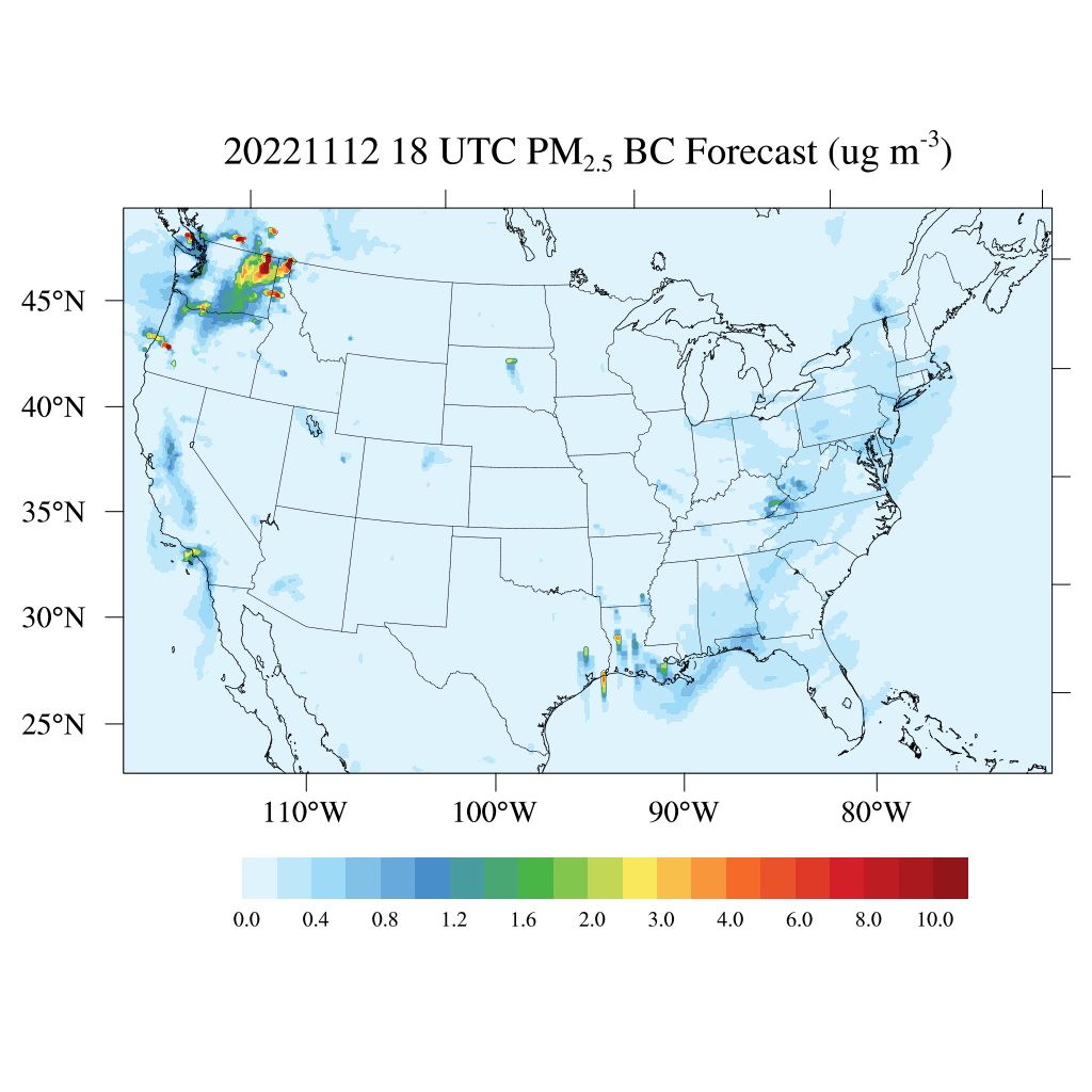
HAQES 3-Hourly Ensemble mean surface PM2.5 Black Carbon concentration, North America V1 (HAQES_NA_PM25_BC) at GES DISC
National Aeronautics and Space Administration —
This product provides HAQES 3-hourly ensemble mean surface PM2.5 Black Carbon concentration over the continental United States (CONUS) and surrounding regions. The... -
Federal
CARIACO Ocean Time Series program, Cariaco Basin, Venezuela
National Aeronautics and Space Administration —
Since November 1995, the CARIACO Ocean Time Series program has been studying the relationship between surface biogeochemical processes and the vertical fluxes of... -
Federal
Leveraging the Hawaii Ocean Time-series program for validation of the PACE Mission in oligotrophic waters
National Aeronautics and Space Administration —
In this project, we leverage the near-monthly, 5-day long expeditions to oligotrophic waters approximately 100 km from Oahu, Hawaii, conducted by the Hawaii Ocean... -
Federal
DISCOVER-AQ Texas Deployment Analysis and Ancillary Ground Site Data
National Aeronautics and Space Administration —
DISCOVERAQ_Texas_Ground_Analysis_Ancillary_Data contains data collected at ancillary ground sites during the Texas (Houston) deployment of NASA's DISCOVER-AQ field...

Official websites use .gov
A
.gov website belongs to an official government
organization in the United States.
Secure .gov websites use HTTPS
A
lock (
) or https:// means you’ve safely connected to
the .gov website. Share sensitive information only on official,
secure websites.