
-
Federal
M2-SCREAM: 3d,3-Hourly,Instantaneous,Model-Level,Assimilation,Assimilated Constituent Fields,Replayed MERRA-2 Meteorological Fields
National Aeronautics and Space Administration —
The MERRA-2 Stratospheric Composition Reanalysis of Aura MLS (M2-SCREAM) products produced at NASA’s Global Modeling and Assimilation Office (GMAO) are generated by... -
Federal
Remote Sensing Data Before and After California Rim and King Forest Fires, 2010-2015
National Aeronautics and Space Administration —
This data set provides high-resolution surface reflectance, thermal imagery, burn severity metrics, and LiDAR-derived structural measures of forested areas in the... -
Federal
SBUV2/NOAA-18 Ozone (O3) Profile and Total Column Ozone 1 Month Zonal Mean L3 Global 5.0 degree Latitude Zones V1 (SBUV2N18L3zm) at GES DISC
National Aeronautics and Space Administration —
The Solar Backscattered Ultraviolet (SBUV) from NOAA-18 Level-3 monthly zonal mean (MZM) product (SBUV2N18L3zm) is derived from the Level-2 retrieved ozone profiles.... -
Federal
2MASS All-Sky Survey Scan Information Table
National Aeronautics and Space Administration —
The 2MASS Scan Information Table provides basic data for each scan in the 2MASS All Sky Release. The table is organized according to the broad function and utility of... -
Federal
CANDELS H-Band Selected Chandra Source Catalog
National Aeronautics and Space Administration —
Improving the capabilities of detecting faint X-ray sources is fundamental to increase the statistics on faint high-z AGN and star-forming galaxies. The authors... -
Federal
AllWISE Multiepoch Photometry Table
National Aeronautics and Space Administration —
The AllWISE program builds upon the work of the successful Wide-field Infrared Survey Explorer mission (WISE; Wright et al. 2010) by combining data from the WISE... -
Federal
Large Quasar Astrometric Catalog, 3rd Release
National Aeronautics and Space Administration —
Since the release of the original Large Quasar Astrometric Catalog (LQAC: Souchay et al. 2009, A&A, 494, 815), a large number of quasars have been discovered... -
Federal
Soil Organic Carbon Stock Estimates with Uncertainty across Latin America
National Aeronautics and Space Administration —
This dataset provides 5 x 5 km gridded estimates of soil organic carbon (SOC) across Latin America that were derived from existing point soil characterization data... -
Federal
BOREAS RSS-10 TOMS Circumpolar One-Degree PAR Images
National Aeronautics and Space Administration —
The BOREAS RSS-10 team investigated the magnitude of daily, seasonal, and yearly variations of PAR from ground and satellite observations. This data set contains... -
Federal
AllWISE Reject Table
National Aeronautics and Space Administration —
The AllWISE program builds upon the work of the successful Wide-field Infrared Survey Explorer mission (WISE; Wright et al. 2010) by combining data from the WISE... -
Federal
SBUV2/NOAA-19 Ozone (O3) Profile and Total Column Ozone 1 Month Zonal Mean L3 Global 5.0 degree Latitude Zones V1 (SBUV2N19L3zm) at GES DISC
National Aeronautics and Space Administration —
The Solar Backscattered Ultraviolet (SBUV) from NOAA-19 Level-3 monthly zonal mean (MZM) product (SBUV2N19L3zm) is derived from the Level-2 retrieved ozone profiles.... -
Federal
ASTER L2 Surface Radiance TIR V003
National Aeronautics and Space Administration —
The Terra Advanced Spaceborne Thermal Emission and Reflection Radiometer (ASTER) Surface Radiance TIR (AST_09T) is generated using the five Thermal Infrared (TIR)... -
Federal
Optically-Selected QSOS NVSS-Detected Source Catalog
National Aeronautics and Space Administration —
The authors used the 1.4-GHz NRAO VLA Sky Survey (NVSS) to study radio sources in two color-selected QSO samples: a volume-limited sample of 1,313 QSOs defined by Mi... -
Federal
ABI G17 Deep Blue L3 Monthly Aerosol Data, 1 x 1 degree grid
National Aeronautics and Space Administration —
The ABI G17 Deep Blue L3 Monthly Aerosol Data, 1 x 1 degree grid product, short-name AERDB_M3_ABI_G17, derived by aggregating the L3 daily (AERDB_D3_ABI_G17) input... -
Federal
NASA-SSH ENSO Sea Surface Height Indicator
National Aeronautics and Space Administration —
This file contains an indicator for the El Nino-Southern Oscillation (ENSO), based on satellite observations of sea surface height anomaly, measured by radar... -
Federal
ASTER Level 1 Precision Terrain Corrected Registered At-Sensor Radiance V031
National Aeronautics and Space Administration —
The Terra Advanced Spaceborne Thermal Emission and Reflection Radiometer (ASTER) Level 1 Precision Terrain Corrected Registered At-Sensor Radiance (AST_L1T) Version... -
Federal
LiDAR Derived Biomass, Canopy Height, and Cover for New England Region, USA, 2015
National Aeronautics and Space Administration —
This dataset provides 30 m gridded estimates of aboveground biomass density (AGBD), forest canopy height, and tree canopy coverage for the New England Region of the... -
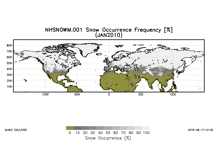
Federal
Northern Hemisphere Snow Cover Monthly Statistics at 1 Degree Resolution V001 (NHSNOWM) at GES DISC
National Aeronautics and Space Administration —
This product is Snow Cover Statistics. The dataset was prepared by Dr. Peter Romanov at Cooperative Institute for Climate Studies(CICS) of the University of Maryland... -
Federal
ACTIVATE GOES-16 Supplementary Data Products
National Aeronautics and Space Administration —
ACTIVATE_Satellite_Data_1 is the GOES-16 satellite data supporting the ACTIVATE suborbital campaign.ACTIVATE was a 5-year NASA Earth-Venture Sub-Orbital (EVS-3) field... -
Federal
GALEX/SDSS Quasar Catalog
National Aeronautics and Space Administration —
This table contains the result of an analysis of the broad-band UV and optical properties of z ~< 3.4 quasars matched in the Galaxy Evolution Explorer (GALEX)...

Official websites use .gov
A
.gov website belongs to an official government
organization in the United States.
Secure .gov websites use HTTPS
A
lock (
) or https:// means you’ve safely connected to
the .gov website. Share sensitive information only on official,
secure websites.