
-
Federal
Bowen Ratio Surface Flux: KSU (FIFE)
National Aeronautics and Space Administration —
The Bowen Ratio Surface Flux Observations (KSU) Data Set contains surface flux measurements made at selected sites within the FIFE area. The sites were equipped with... -
Federal
SAFARI 2000 Woody Vegetation Characteristics of Kalahari and Skukuza Sites
National Aeronautics and Space Administration —
This data set contains species composition, basal area, height, and crown cover of all woody plants at six sites along the Kalahari Transect visited in February-March... -
Federal
NACP Peatland Landcover Type and Wildfire Burn Severity Maps, Alberta, Canada
National Aeronautics and Space Administration —
This data set provides landcover maps of (1) peatland type (bog, fen, marsh, swamp) with levels of biomass (open, forested) and (2) Burn Severity Index (BSI) (Dyrness... -
Federal
LBA-ECO CD-04 Leaf Litter Data, km 83 Tower Site, Tapajos National Forest, Brazil
National Aeronautics and Space Administration —
Above-ground litter productivity was measured in a 18 ha plot adjacent to the eddy flux tower at the logged forest tower site, km 83, Tapajos National Forest, Para,... -
Federal
Water Quality and Spectral Reflectance, Peace-Athabasca Delta, Canada, 2010-2011
National Aeronautics and Space Administration —
The Peace-Athabasca Delta (PAD) is a hydrologically complex and ecologically diverse freshwater delta formed by the confluence of the Peace, Athabasca, and Birch... -
Federal
SAFARI 2000 Landscape Photographs of Kalahari Transect, Mongu, Skukuza Sites
National Aeronautics and Space Administration —
This data set contains Global Positioning System (GPS) imprinted landscape photographs at 100 m intervals along the Large Grid Transects at Kalahari Transect sites in... -
Federal
SAFARI 2000 Vegetation Cover Characteristics, Kalahari Transect, Wet Season 2000
National Aeronautics and Space Administration —
Vegetation cover and composition, including species types and richness assessments, were measured at four locations along the Kalahari Transect in Botswana... -
Federal
LBA-ECO LC-05 Biomass and Soil Properties of Fragmented Forests, Amazonas, Brazil
National Aeronautics and Space Administration —
This data set reports (1) total aboveground dry biomass based on detailed estimates of all live and dead plant material, (2) results from repeated surveys of... -
Federal
SAFARI 2000 AOT and Column Water Vapor, Kalahari Transect, Wet Season 2000
National Aeronautics and Space Administration —
The data presented here include the aerosol optical thickness (AOT) and column water vapor measurements taken at sites along the Kalahari Transect using a Microtops... -
Federal
SAFARI 2000 PAI Estimates from Hemispherical Photography, Kalahari Transect
National Aeronautics and Space Administration —
This data set was collected during February-March 2000 wet season and September 2000 dry season field campaigns of SAFARI 2000. Mongu in Zambia and Pandematenga (aka... -
Federal
BigFoot GPP Surfaces for North and South American Sites, 2000-2004
National Aeronautics and Space Administration —
The BigFoot project gathered Gross Primary Production (GPP) data for nine EOS Land Validation Sites located from Alaska to Brazil from 2000 to 2004. Each site is... -
Federal
SAFARI 2000 Leaf Measurements of Dominant Trees, Kalahari Sites, Wet Season 2000
National Aeronautics and Space Administration —
Data presented in this data set were collected during an intensive field campaign in Botswana between February 28 and March 18, 2000 along the Kalahari Transect as... -
Federal
NPP Boreal Forest: Siberian Scots Pine Forests, Russia, 1968-1974, R1
National Aeronautics and Space Administration —
This data set contains two files (comma-separated-value format). One file provides components of net primary productivity, standing biomass, age and stand structure,... -
Federal
NDVI, Species Cover, and LAI, Burned and Unburned sites, Interior Alaska, 2017-2018
National Aeronautics and Space Administration —
This dataset provides leaf area index (LAI), tree species and canopy cover, normalized difference vegetation index (NDVI), and NDVI trends for boreal forests in... -
Federal
BOREAS TGB-05 Dissolved Organic Carbon Data from NSA Beaver Ponds
National Aeronautics and Space Administration —
The BOREAS TGB-05 team collected several data sets related to carbon and trace gas fluxes and concentrations in the NSA. This data set contains concentrations of... -
Federal
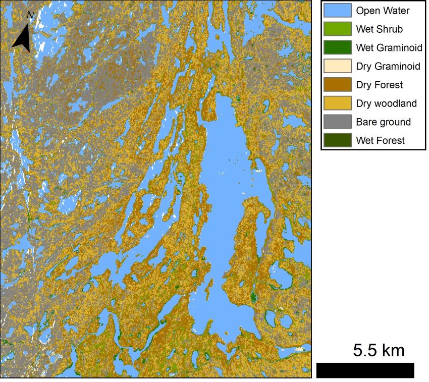
ABoVE: Lake and Wetland Classification from L-band SAR, Alaska and Canada, 2017-2019
National Aeronautics and Space Administration —
This dataset contains a high-resolution land cover classification focused on water and wetland vegetation classes over three NASA ABoVE Campaign regions: Yukon Flats,... -
Federal
NPP Multi-Biome: PIK Data for Northern Eurasia, 1940-1988 (Based on Bazilevich), R1
National Aeronautics and Space Administration —
There is one comma-separated (.csv) data file and one text (.txt) file (bibliographic information) with this data set. This data set provides above-ground net primary... -
Federal
SAFARI 2000 Cloud Physics Lidar (CPL) Quicklook Images and Maps
National Aeronautics and Space Administration —
The effect of clouds and aerosols on regional and global climate is of great importance. Two longstanding elements of the NASA climate and radiation science program... -
Federal
BigFoot NPP Surfaces for North and South American Sites, 2000-2004
National Aeronautics and Space Administration —
The BigFoot project gathered Net Primary Production (NPP) data for nine EOS Land Validation Sites located from Alaska to Brazil from 2000 to 2004. Each site is...

Official websites use .gov
A
.gov website belongs to an official government
organization in the United States.
Secure .gov websites use HTTPS
A
lock (
) or https:// means you’ve safely connected to
the .gov website. Share sensitive information only on official,
secure websites.