
-
Federal
LiDAR Derived Biomass, Canopy Height, and Cover for New England Region, USA, 2015 recent views
National Aeronautics and Space Administration —
This dataset provides 30 m gridded estimates of aboveground biomass density (AGBD), forest canopy height, and tree canopy coverage for the New England Region of the... -
Federal
ABoVE: Burn Severity, Fire Progression, Landcover and Field Data, NWT, Canada, 2014 NGDA recent views
National Aeronautics and Space Administration —
This data set provides peatland landcover classification maps, fire progression maps, and vegetation community biophysical data collected from areas that were burned... -
Federal
Forest Inventory and Biophysical Measurements, Brazilian Amazon, 2009-2018 recent views
National Aeronautics and Space Administration —
This dataset provides the complete catalog of forest inventory and biophysical measurements collected over selected forest research sites across the Amazon rainforest... -
Federal
LBA-ECO LC-02 Biophysical Measurements of Forests, Acre, Brazil: 1999-2002 recent views
National Aeronautics and Space Administration —
This data set provides diameter at breast height (DBH) measurements for 1,063 trees located at the Catuaba Experimental Farm, and 812 trees located in the Humaita... -
Federal
LBA-ECO LC-14 Biophysical Measurements, Rainfall Exclusion, Tapajos National Forest recent views
National Aeronautics and Space Administration —
This data set reports forest biophysical measurements from a rainfall exclusion experiment conducted at the km 67 Seca Floresta site, Tapajos National Forest, Brazil... -
Federal
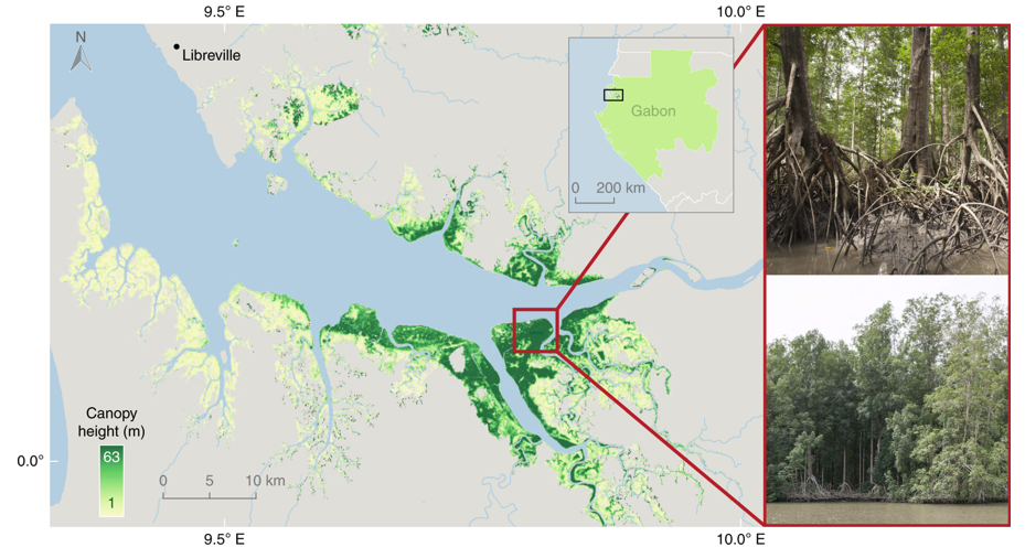
Global Mangrove Distribution, Aboveground Biomass, and Canopy Height recent views
National Aeronautics and Space Administration —
This dataset characterizes the global distribution, biomass, and canopy height of mangrove-forested wetlands based on remotely sensed and in situ field measurement... -
Federal
GEDI L4A Footprint Level Aboveground Biomass Density, Version 2.1 recent views
National Aeronautics and Space Administration —
This dataset contains Global Ecosystem Dynamics Investigation (GEDI) Level 4A (L4A) Version 2 predictions of the aboveground biomass density (AGBD; in Mg/ha) and... -
Federal
GEDI L4A Footprint Level Aboveground Biomass Density, Golden Weeks, Version 1 recent views
National Aeronautics and Space Administration —
This dataset contains Global Ecosystem Dynamics Investigation (GEDI) Level 4A (L4A) predictions of the aboveground biomass density (AGBD; in Mg/ha) and estimates of... -
Federal
LBA-ECO CD-10 Ground-based Biometry Data at km 67 Tower Site, Tapajos National Forest recent views
National Aeronautics and Space Administration —
This data sets contains a single text file which reports biometry measurements of the old-growth upland forest at the Parao Western (Santarem) - km 67, Primary Forest... -
Federal
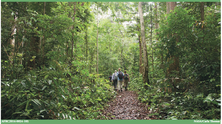
AfriSAR: Mondah Forest Tree Species, Biophysical, and Biomass Data, Gabon, 2016 recent views
National Aeronautics and Space Administration —
This dataset provides plot-level estimates of basal area, aboveground biomass, number of trees, maximum tree height, and basal-area-weighted wood specific gravity... -
Federal
AfriSAR: Aboveground Biomass for Lope, Mabounie, Mondah, and Rabi Sites, Gabon recent views
National Aeronautics and Space Administration —
This dataset provides gridded estimates of aboveground biomass (AGB) for four sites in Gabon at 0.25 ha (50 m) resolution derived with field measurements and airborne... -
Federal
LBA-ECO ND-11 Forest Damage Following Reduced Impact Logging, NW Mato Grosso, Brazil recent views
National Aeronautics and Space Administration —
Data were collected in the logging concession at the Fazenda Rohsamar in the municipality of Juruena in northwestern Mato Grosso. Estimates of damage associated with... -
Federal
LBA-ECO CD-17 Secondary Forest Survey, Para and Rondonia, Brazil: 2002-2003 recent views
National Aeronautics and Space Administration —
This data set provides measurements for diameter at breast height (DBH), tree height, distance from tree stems to the furthest canopy element, and a species survey of... -
Federal
SAFARI 2000 Tree Ring Data, Mongu, Zambia, Dry Season 2000 recent views
National Aeronautics and Space Administration —
This data set contains tree ring data from three sites located about 25 km of the meteorological station at Mongu, Zambia. Data from about 50 individual trees are... -
Federal
SAFARI 2000 Woody Vegetation Characteristics of Kalahari and Skukuza Sites recent views
National Aeronautics and Space Administration —
This data set contains species composition, basal area, height, and crown cover of all woody plants at six sites along the Kalahari Transect visited in February-March... -
Federal
ECHIDNA LIDAR Campaigns: Forest Canopy Imagery and Field Data, U.S.A., 2007-2009 recent views
National Aeronautics and Space Administration —
This data set contains forest canopy scan data from the Echidna? Validation Instrument (EVI) and field measurements data from three campaigns conducted in the United... -
Federal
LBA-ECO ND-02 Secondary Forest Tree Heights and Diameters, Para, Brazil: 1999-2005 recent views
National Aeronautics and Space Administration —
This data set provides tree diameters and heights measured from 1999 to 2005 in plots of a secondary-growth forest fertilization experiment located 6.5-km northwest... -
Federal
BOREAS HYD-03 SSA/OLD Aspen DBH Data recent views
National Aeronautics and Space Administration —
The BOREAS HYD-03 team collected several data sets related to the hydrology of forested areas. This data set contains measurements of tree diameter at breast height... -
Federal
LBA-ECO CD-08 Coarse Wood Litter Respiration and Decomposition, Manaus, Brazil recent views
National Aeronautics and Space Administration —
This data sets contains data on coarse wood density, moisture content, respiration rates and decomposition rate constants in csv format from Manaus Brazil measured... -
Federal
LBA-ECO CD-08 Tree Inventory Data, Ducke Reserve, Manaus, Brazil: 1999 recent views
National Aeronautics and Space Administration —
This data set includes in one data file the common names, base diameters, and calculated tree masses for almost 3,000 trees on a 5 hectare plot (20 x 2,500 m) located...

Official websites use .gov
A
.gov website belongs to an official government
organization in the United States.
Secure .gov websites use HTTPS
A
lock (
) or https:// means you’ve safely connected to
the .gov website. Share sensitive information only on official,
secure websites.