
-
Federal
ASTER Global DEM NGDA
National Aeronautics and Space Administration —
ASTER is capable of collecting in-track stereo using nadir- and aft-looking near infrared cameras. Since 2001, these stereo pairs have been used to produce single-... -
Federal
PEM Tropics B P-3B Trajectory Data
National Aeronautics and Space Administration —
PEM-Tropics-B_Trajectory_P3B_Data is the trajectory data collected onboard the P-3B aircraft during the Pacific Exploratory Mission (PEM) Tropics B suborbital... -
Federal
CERES ERBE-like Gridded Instantaneous TOA Fluxes (ES9) NPP CERES FM-5 Edition2
National Aeronautics and Space Administration —
The ERBE-like Monthly Regional Averages (ES-9) product contains a month of space and time-averaged Clouds and the Earth's Radiant Energy System (CERES) data for a... -
Federal
SWOT Level 2 Radiometer Brightness Temperatures and Troposphere Interim Data Product Version D
National Aeronautics and Space Administration —
The SWOT Level 2 Radiometer Brightness Temperatures and Troposphere Interim Geophysical Data Record (IGDR) Version D dataset produced by the Surface Water and Ocean... -
Federal
BARREL 4E X-ray Spectrometer (XSPC) Bremsstrahlung X-ray, 30-channel Spectrum, Level 2, 0.05 s Data
National Aeronautics and Space Administration —
XSPC: 30 channels of fast time resolution, 50 ms, Bremsstrahlung X-ray spectra. The channel count data are in raw format. The energy levels for bins in each record... -
Federal
LIMS/Nimbus-7 Level 2 Vertical Profiles of O3, NO2, H2O, HNO3, Geopotential Height, and Temperature V006 (LIMSN7L2) at GES DISC
National Aeronautics and Space Administration —
The Limb Infrared Monitor of the Stratosphere (LIMS) version 6 Level-2 data product consists of daily, geolocated, vertical profiles of temperature, geopotential... -
Federal
Stream Flow Daily Data: USGS (FIFE)
National Aeronautics and Space Administration —
The Daily Stream Flow Amounts Data Set contains daily measurements of stream flow for the four LTER stations and for the USGS stream-flow station located on... -
Federal
AIRS/Aqua L2 Near Real Time (NRT) Cloud-Cleared Infrared Radiances (AIRS-only) V006 (AIRS2CCF_NRT) at GES DISC
National Aeronautics and Space Administration —
The Atmospheric Infrared Sounder (AIRS) Level 2 Near Real Time (NRT) Cloud-Cleared Infrared Radiances (AIRS-only) product (AIRS2CCF_NRT_006) differs from the routine... -
Federal
GEDI L2B Canopy Cover and Vertical Profile Metrics Data Global Footprint Level V002
National Aeronautics and Space Administration —
The Global Ecosystem Dynamics Investigation (GEDI) mission aims to characterize ecosystem structure and dynamics to enable... -
Federal
GPM Ground Validation Conical Scanning Millimeter-wave Imaging Radiometer (CoSMIR) OLYMPEX
National Aeronautics and Space Administration —
The GPM Ground Validation Conical Scanning Millimeter-wave Imaging Radiometer (CoSMIR) OLYMPEX dataset consists of brightness temperatures from 9 channels as measured... -
Federal
SCR/Nimbus-4 Level 1 Calibrated Radiances V001 (SCRN4L1RAD) at GES DISC
National Aeronautics and Space Administration —
SCRN4L1RAD is the Nimbus-4 Selective Chopper Radiometer (SCR) Level 1 Calibrated Radiances data product. The calibrated radiances are measured at 6 channels from 2.3... -
Federal
Sounder SIPS: JPSS-1 ATMS Level 2 RAMSES2 Standard: Atmosphere, precipitation and surface geophysical state V3 (SNDRJ1ML2RMS) at GES DISC
National Aeronautics and Space Administration —
This level 2 product is generated by the RAMSES (Retrieval Algorithm for Microwave Sounders in Earth Science II algorithm.The RAMSES II algorithm is a microwave only... -
Federal
Sounder SIPS: Suomi NPP CrIMSS Level 3 Comprehensive Quality Control Gridded Daily CLIMCAPS Full Spectral Resolution V2 (SNDRSNIML3CDCCP) at GES DISC
National Aeronautics and Space Administration —
WARNING: To users of the derived product “co_mmr_midtrop” (carbon monoxide mass mixing ratio to dry air [kg/kg] at ~500 hPa). This variable has a significant bias due... -
Federal
TROPICS03 L2B Tropical Cyclone Intensity Estimate (TCIE) Algorithm V1.0
National Aeronautics and Space Administration —
The "Time-Resolved Observations of Precipitation structure and storm Intensity with a Constellation of Smallsats" (TROPICS) mission has a goal of providing nearly... -
Federal
SWOT Level 2 Water Mask Pixel Cloud Auxiliary Data Product, Version D
National Aeronautics and Space Administration —
The SWOT Level 2 Water Mask Pixel Cloud Auxiliary Data Product (SWOT_L2_HR_PIXCVec_D) provides per-feature attributes for surface water bodies identified from the Ka-... -
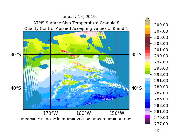
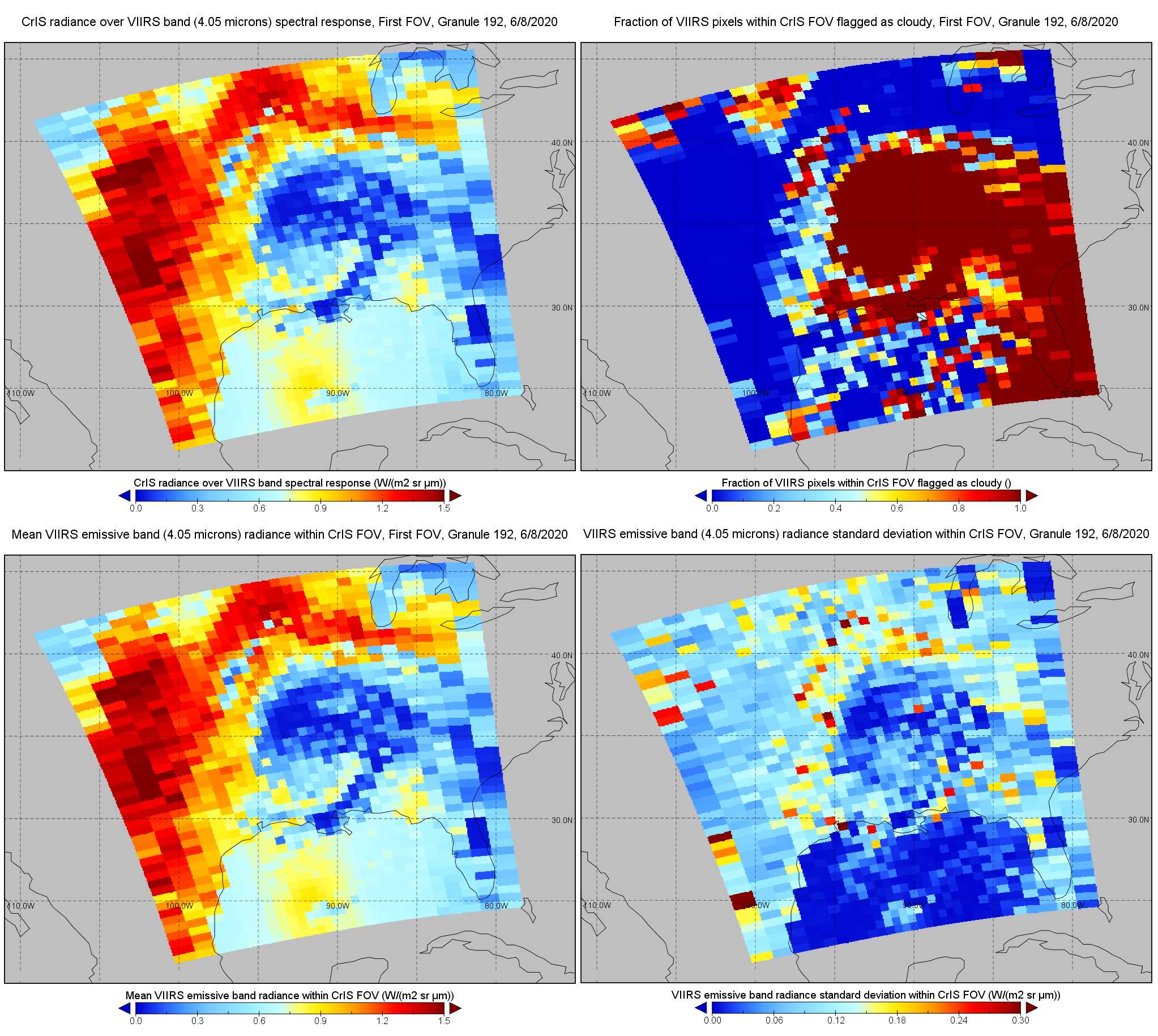
Federal
S-NPP CrIS IMG: Collocated VIIRS level 1 / cloud mask statistical summary V2 (SNDRSNCrISL1BIMG) at GES DISC
National Aeronautics and Space Administration —
The Cross-track Infrared Sounder (CrIS) Level 1B Normal Spectral Resolution (NSR) data files contain radiance measurements along with ancillary spacecraft,... -
Federal
SWOT Level 2 KaRIn Low Rate Sea Surface Height Data Product, Version 2.0
National Aeronautics and Space Administration —
The SWOT Level 2 KaRIn Low Rate Sea Surface Height Data Product from the Surface Water Ocean Topography (SWOT) mission provides global sea surface height and...

Official websites use .gov
A
.gov website belongs to an official government
organization in the United States.
Secure .gov websites use HTTPS
A
lock (
) or https:// means you’ve safely connected to
the .gov website. Share sensitive information only on official,
secure websites.