
-
Federal
Lunar Map Catalog
National Aeronautics and Space Administration —
The Lunar Map Catalog includes various maps of the moon's surface, including Apollo landing sites; earthside, farside, and polar charts; photography index maps; zone... -
Federal
MISR Level 1B2 Ellipsoid Data V004
National Aeronautics and Space Administration —
MI1B2E_004 is the Multi-angle Imaging SpectroRadiometer (MISR) Level 1B2 Ellipsoid Data Version 4 product. It contains Ellipsoid-projected Top-of-Atmosphere (TOA)... -
Federal
LBA-ECO ND-11 Pre-harvest Forest Tree and Liana Biomass, NW Mato Grosso, Brazil: 2003
National Aeronautics and Space Administration —
The purpose of this study was to determine if spatially-explicit commercial timber inventories (CTI) could be used in conjunction with satellite imagery to improve... -
Federal
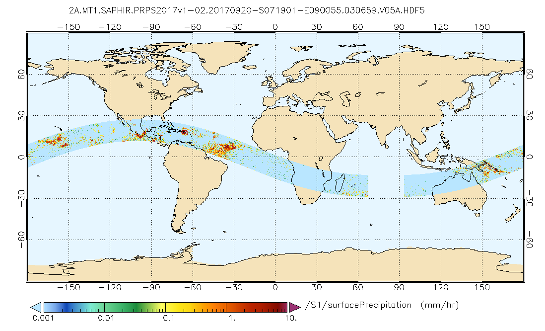
GPM SAPHIR on MT1 (PRPS) Climate-based Radiometer Precipitation Profiling L2 1.5 hours 10 km V06 (GPM_2APRPSMT1SAPHIR_CLIM) at GES DISC
National Aeronautics and Space Administration —
Version 6 is the current version of this dataset. Older versions are no longer available and have been superseded by Version 6.The Precipitation Retrieval and... -
Federal
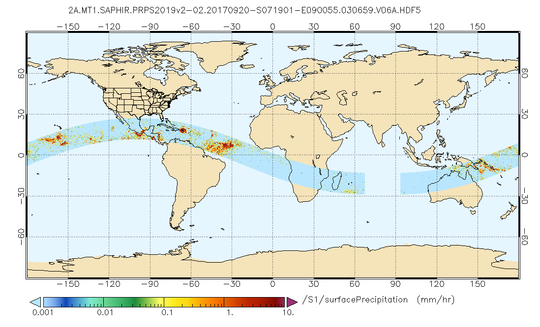
GPM SAPHIR on MT1 (PRPS) Radiometer Precipitation Profiling L2 1.5 hours 10 km V06 (GPM_2APRPSMT1SAPHIR) at GES DISC
National Aeronautics and Space Administration —
Version 6 is the current version of this dataset. Older versions are no longer available and have been superseded by Version 6.The Precipitation Retrieval and... -
Federal
MISR L1B2 Ellipsoid Product subset for the ARCTAS region V003
National Aeronautics and Space Administration —
ATSMIB2E_003 is the Multi-angle Imaging SpectroRadiometer (MISR) Level 1B2 Ellipsoid Product subset for the ARCTAS region. It contains an Ellipsoid-projected TOA... -
Federal
MISR L2 TOA/Cloud Classifier Product subset for the RICO region V003
National Aeronautics and Space Administration —
RICMITCL_003 is the Multi-angle Imaging SpectroRadiometer (MISR) Level 2 TOA/Cloud Classifier Product subset for the RICO region, version 2 data product. It contains... -
Federal
ABoVE: Wetland Type, Slave River and Peace-Athabasca Deltas, Canada, 2007 and 2017
National Aeronautics and Space Administration —
This dataset provides ecosystem-types for the Slave River Delta (SRD) and Peace-Athabasca Delta (PAD), Canada, for the time periods circa 2007 and circa 2017. The... -
Federal
ASTER Global Digital Elevation Model V002
National Aeronautics and Space Administration —
The ASTGTM.002 dataset was decommissioned as of August 5, 2019. Users are encouraged to use the new improved ASTGTM.003 dataset.The ASTER Global Digital Elevation... -
Federal
MISR Level 1B2 Ellipsoid Data V003
National Aeronautics and Space Administration —
Multi-angle Imaging SpectroRadiometer (MISR) is an instrument designed to view Earth with cameras pointed in 9 different directions. As the instrument flies overhead,... -
Federal
MISR Level 1B2 Terrain Data V004
National Aeronautics and Space Administration —
MI1B2T_004 is the Multi-angle Imaging SpectroRadiometer (MISR) Level 1B2 Terrain Data Version 4 product. It contains Terrain-projected Top-of-Atmosphere (TOA)... -
Federal
MODIS/Aqua Near Real Time (NRT) Aerosol 5-Min L2 Swath 10km
National Aeronautics and Space Administration —
The MODIS level-2 atmospheric aerosol product (MYD04_L2) continues to provide full global coverage of aerosol properties from the Dark Target (DT) and Deep Blue (DB)... -
Federal
ASTER Global Water Bodies Database Attributes NetCDF V001
National Aeronautics and Space Administration —
The Terra Advanced Spaceborne Thermal Emission and Reflection Radiometer (ASTER) Global Water Bodies Database (ASTWBD) Version 1 data product provides global coverage... -
Federal
High-Resolution QuickBird Imagery and Related GIS Layers for Barrow, Alaska, USA, Version 1
National Aeronautics and Space Administration —
This data set contains high-resolution QuickBird imagery and geospatial data for the entire Barrow QuickBird image area (156.15° W - 157.07° W, 71.15° N - 71.41° N)... -
Federal
ISLSCP II HYDRO1k Elevation-derived Products
National Aeronautics and Space Administration —
This data set contains coarse scale elevation and elevation-based parameters at 1.0 and 0.5-degree spatial resolutions that were developed to support a wide variety... -
Federal
MODIS/Aqua Near Real Time (NRT) Aerosol 5-Min L2 Swath - 3km
National Aeronautics and Space Administration —
The MODIS level-2 atmospheric aerosol product provides retrieved ambient aerosol optical properties (e.g., optical thickness and size distribution), mass... -
Federal
MISR Level 1B2 Local Mode Terrain Radiance Data subset for the UAE region V002
National Aeronautics and Space Administration —
UAEM1LMT_002 is the Multi-angle Imaging SpectroRadiometer (MISR) Level 1B2 Local Mode Terrain Radiance Data subset for the UAE region. It contains the terrain-... -
Federal
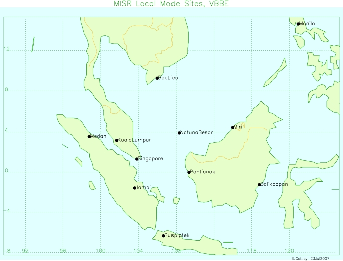
MISR Level 1B2 Terrain Product subset for the VBBE region V003
National Aeronautics and Space Administration —
VBEMIB2T_003 is the Multi-angle Imaging SpectroRadiometer (MISR) Level 1B2 Terrain Product subset for the VBBE region version 3. It contains Terrain-projected TOA... -
Federal
MISR Level 1B2 Terrain Data subset for the UAE region V003
National Aeronautics and Space Administration —
UAEMIB2T_003 is the Multi-angle Imaging SpectroRadiometer (MISR) Level 1B2 Terrain Data subset for the UAE region version 3 data product. It contains Terrain-...

Official websites use .gov
A
.gov website belongs to an official government
organization in the United States.
Secure .gov websites use HTTPS
A
lock (
) or https:// means you’ve safely connected to
the .gov website. Share sensitive information only on official,
secure websites.