

9 datasets found for "Tides"
-
Federal
SWOT Level 2 River Single-Pass Vector Data Product, Version D
National Aeronautics and Space Administration —
The SWOT Level 2 River Single-Pass Vector Data Product (SWOT_L2_HR_RiverSP_D) provides hydrologic measurements for predefined river reaches and nodes, derived from... -
Federal
SWOT Level 2 Water Mask Raster Image 100m Data Product, Version D
National Aeronautics and Space Administration —
The SWOT Level 2 KaRIn High Rate Raster Product (SWOT_L2_HR_Raster_D) provides rasterized estimates of water surface elevation, inundation extent, and radar... -
Federal
SWOT Level 2 Water Mask Pixel Cloud Data Product, Version D
National Aeronautics and Space Administration —
The SWOT Level 2 Water Mask Pixel Cloud Product (SWOT_L2_HR_PIXC_D) provides high-resolution, geolocated observations of terrestrial surface water pixels detected by... -
Federal
Resilience of Coastal Wetlands to Sea Level Rise, CONUS, 1996-2100
National Aeronautics and Space Administration —
This dataset provides information about the resilience of tidal wetlands to sea-level rise under three scenarios of global change. With rising seas, regularly... -
Federal
SWOT Level 2 Lake Single-Pass Vector Data Product, Version D
National Aeronautics and Space Administration —
The SWOT Level 2 Lake Single-Pass Vector Product (SWOT_L2_HR_LakeSP_D) provides geolocated surface water measurements for lakes and unclassified water bodies, derived... -
Federal
Relative Tidal Marsh Elevation Maps with Uncertainty for Conterminous USA, 2010
National Aeronautics and Space Administration —
This dataset provides maps of the elevation of coastal wetlands relative to tidal ranges for the conterminous United States (CONUS) at 30 m resolution for 2010. It... -
Federal
Integrated Multi-Mission Ocean Altimeter Data for Climate Research Version 5.2
National Aeronautics and Space Administration —
The Integrated Multi-Mission Ocean Altimeter Sea Surface Height (SSH) Version 5.2 dataset provides level 2 along track sea surface height anomalies (SSHA) for 10-day... -
Federal
TOPEX/POSEIDON Geophysical Data Record Version F
National Aeronautics and Space Administration —
The TOPEX/POSEIDON Geophysical Data Record (GDR) contains global coverage altimeter data. The objective of the TOPEX/POSEIDON mission, launched in August 1992, is to... -
Federal
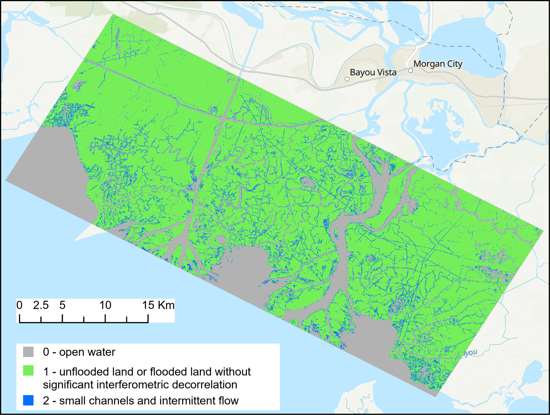
Pre-Delta-X: UAVSAR Georeferenced Channel Maps, Atchafalaya Basin, LA, USA, 2016, V2
National Aeronautics and Space Administration —
This dataset provides spatial data on water channels in the estuary of the Atchafalaya Basin of the Mississippi River Delta of coastal Louisiana. These Level-3 (L3)...
9 datasets found for "Tides"