
-
Federal
Daily and Annual PM2.5 Concentrations for the Contiguous United States, 1-km Grids, v1 (2000 - 2016)
National Aeronautics and Space Administration —
The Daily and Annual PM2.5 Concentrations for the Contiguous United States, 1-km Grids, v1 (2000 - 2016) data set includes predictions of PM2.5 concentrations in grid... -
Federal
ECOSTRESS Evapotranspiration dis-ALEXI USDA Daily L3 Global 30m V001
National Aeronautics and Space Administration —
The ECOsystem Spaceborne Thermal Radiometer Experiment on Space Station (ECOSTRESS) mission measures the temperature of plants to better understand how much water... -
Federal
OCO-3 Level 2 CO2 prior based on CO2 monthly flask record, global meteorology, and age of air, Forward Processing V11 (OCO3_L2_CO2Prior) at GES DISC
National Aeronautics and Space Administration —
Version 11 is the current version of the data set. Older versions will no longer be available and are superseded by Version 11. The Orbiting Carbon Observatory -3... -
Federal
VIIRS/NPP Actual and Potential Evapotranspiration Gap-Filled 8-Day L4 Global 500m SIN Grid V002
National Aeronautics and Space Administration —
The NASA/NOAA Suomi National Polar-orbiting Partnership (Suomi NPP) Visible Infrared Imaging Radiometer Suite (VIIRS) Actual and Potential Evapotranspiration product... -
Federal
GHRSST Level 4 DMI_OI Global Foundation Sea Surface Temperature Analysis (GDS version 2)
National Aeronautics and Space Administration —
A Group for High Resolution Sea Surface Temperature (GHRSST) Level 4 sea surface temperature analysis produced daily on an operational basis by the Danish... -
Federal
OCO-3 Level 2 CO2 prior based on CO2 monthly flask record, global meteorology, and age of air, Forward Processing V10 (OCO3_L2_CO2Prior) at GES DISC
National Aeronautics and Space Administration —
Version 10 is the current version of the data set. Older versions will no longer be available and are superseded by Version 10. The Orbiting Carbon Observatory -3... -
Federal
Aquarius CAP Level 3 Sea Surface Salinity Standard Mapped Image 7-Day Data V5.0
National Aeronautics and Space Administration —
Version 5.0 Aquarius CAP Level 3 products are the fourth release of the AQUARIUS/SAC-D mapped salinity and wind speed data based on the Combined Active Passive (CAP)... -
Federal
Daily and Annual NO2 Concentrations for the Contiguous United States, 1-km Grids, v1 (2000 - 2016)
National Aeronautics and Space Administration —
The Daily and Annual NO2 Concentrations for the Contiguous United States, 1-km Grids, v1 (2000-2016) data set contains daily predictions of Nitrogen Dioxide (NO2)... -
Federal
SPURS-2 Rawinsonde meteorological data for the E. Tropical Pacific field campaign R/V Revelle cruises
National Aeronautics and Space Administration —
The SPURS (Salinity Processes in the Upper Ocean Regional Study) project is NASA-funded oceanographic process study and associated field program that aim to elucidate... -
Federal
SPURS-2 Research vessel Meteorological series data for the E. Tropical Pacific field campaign R/V Revelle cruises
National Aeronautics and Space Administration —
The SPURS (Salinity Processes in the Upper Ocean Regional Study) project is a NASA-funded oceanographic process study and associated field program that aim to... -
Federal
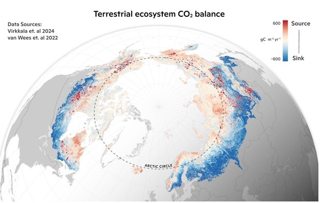
Machine learning-based Arctic-boreal terrestrial ecosystem CO2 fluxes, 2001-2020
National Aeronautics and Space Administration —
This dataset provides gridded estimates of gross primary productivity (GPP), ecosystem respiration (Reco), and net ecosystem CO2 exchange (NEE) across the circumpolar... -
Federal
AIRS/Aqua L1B Near Real Time (NRT) Infrared (IR) geolocated and calibrated radiances in BUFR format V005 (AIRIBRAD_NRT_BUFR) at GES DISC
National Aeronautics and Space Administration —
WARNING: On 2021/09/23 the EOS Aqua executed a Deep Space Maneuver (DSM). In the DSM, the spacecraft is turned such that the normal Earth field of regard is deep... -
Federal
MetOp-A ASCAT Level 2 Ocean Surface Wind Vectors Optimized for Coastal Ocean
National Aeronautics and Space Administration —
This dataset contains operational near-real-time Level 2 coastal ocean surface wind vector retrievals from the Advanced Scatterometer (ASCAT) on MetOp-A at 12.5 km... -
Federal
Daily 8-Hour Maximum and Annual O3 Concentrations for the Contiguous United States, 1-km Grids, v1 (2000 - 2016)
National Aeronautics and Space Administration —
The Daily 8-Hour Maximum and Annual O3 Concentrations for the Contiguous United States, 1-km Grids, v1 (2000 - 2016) data set contains estimates of ozone... -
Federal
Daily and Annual PM2.5, O3, and NO2 Concentrations at ZIP Codes for the Contiguous U.S., 2000-2016, v1.0
National Aeronautics and Space Administration —
The Daily and Annual PM2.5, O3, and NO2 Concentrations at ZIP Codes for the Contiguous U.S., 2000-2016, v1.0 data set contains daily and annual concentration... -
Federal
Daily 8-Hour Maximum and Annual O3 Concentrations for the Contiguous United States, 1-km Grids, Version 1.10 (2000-2016)
National Aeronautics and Space Administration —
The Daily 8-Hour Maximum and Annual O3 Concentrations for the Contiguous United States, 1-km Grids, Version 1.10 (2000-2016) data set contains estimates of ozone... -
Federal
MetOp-B ASCAT Level 2 Ocean Surface Wind Vectors Optimized for Coastal Ocean
National Aeronautics and Space Administration —
This dataset contains operational near-real-time Level 2 coastal ocean surface wind vector retrievals from the Advanced Scatterometer (ASCAT) on MetOp-B at 12.5 km... -
Federal
ATom: CAM-chem/CESM2 Model Outputs Along Flight Tracks, 2016-2018
National Aeronautics and Space Administration —
This dataset contains CAM-chem (Community Atmosphere Model with Chemistry) model outputs along ATom flight tracks. CAM-chem is a component of the Community Earth... -
Federal
GHRSST NOAA/STAR ACSPO v2.80 0.02 degree L3S Dataset from mid-Morning LEO Satellites (GDS v2)
National Aeronautics and Space Administration —
NOAA STAR produces two lines of gridded 0.02 degree super-collated L3S LEO sub-skin Sea Surface Temperature (SST) datasets, one from the NOAA afternoon JPSS... -
Federal
VIIRS Plus DMSP Change in Lights (VIIRS+DMSP dLIGHT)
National Aeronautics and Space Administration —
The VIIRS Plus DMSP Change in Lights (VIIRS+DMSP dLIGHT) data set fuses nighttime lights imagery from the U.S. Air Force Defense Meteorological Satellite Program...

Official websites use .gov
A
.gov website belongs to an official government
organization in the United States.
Secure .gov websites use HTTPS
A
lock (
) or https:// means you’ve safely connected to
the .gov website. Share sensitive information only on official,
secure websites.