
-
Federal
ALOS PALSAR High Resolution Radiometric Terrain Corrected Product
National Aeronautics and Space Administration —
ASF's SAR Radiometric Terrain Corrected (RTC) dataset gives terrestrial world-wide coverage; excluding Antarctica, Greenland, Iceland, and Asia north of 60 degrees... -
Federal
UAVSAR_POLSAR_METADATA
National Aeronautics and Space Administration —
UAVSAR PolSAR Scene Metadata -
Federal
UAVSAR_POLSAR_INCIDENCE
National Aeronautics and Space Administration —
UAVSAR PolSAR Scene Incidence Angle -
Federal
CMS: Aboveground Biomass for Mangrove Forest, Zambezi River Delta, Mozambique
National Aeronautics and Space Administration —
This dataset provides several estimates of aboveground biomass from various regressions and allometries for mangrove forest in the Zambezi River Delta, Mozambique.... -
Federal
RADARSAT-1 Level 0 Product
National Aeronautics and Space Administration —
RADARSAT-1 Level 0 -
Federal
ALOS PALSAR Level 1.0 Product
National Aeronautics and Space Administration —
ALOS PALSAR Level 1.0 -
Federal
Global Mangrove Forests Distribution, 2000
National Aeronautics and Space Administration —
The Global Mangrove Forests Distribution, 2000 data set is a compilation of the extent of mangroves forests from the Global Land Survey and the Landsat archive with... -
Federal
UAVSAR_POLSAR_SLOPE
National Aeronautics and Space Administration —
UAVSAR PolSAR Scene Slope -
Federal
Delta-X: NUMAR Predictive Model for Marsh Accretion Rates and Chemical Properties
National Aeronautics and Space Administration —
This dataset provides input data and model code to run the Marsh Accretion Rates (NUMAR) process model used to predict soil accretion rates and chemical properties... -
Federal
UAVSAR_POLSAR_ML_COMPLEX_GRD
National Aeronautics and Space Administration —
UAVSAR PolSAR Scene Projected -
Federal
West Africa Coastal Vulnerability Mapping: Mangrove Forests Distribution, 2000 Polygon
National Aeronautics and Space Administration —
The West Africa Coastal Vulnerability Mapping: Mangrove Forests Distribution, 2000 Polygon data set was derived from the 30m resolution NASA Socioeconomic Data and... -
Federal
ALOS PALSAR Low Resolution Radiometric Terrain Corrected Product
National Aeronautics and Space Administration —
ASF's SAR Radiometric Terrain Corrected (RTC) dataset gives terrestrial world-wide coverage; excluding Antarctica, Greenland, Iceland, and Asia north of 60 degrees... -
Federal
RADARSAT-1 Level 1 Product
National Aeronautics and Space Administration —
RADARSAT-1 Level 1 Amplitude Images -
Federal
UAVSAR_POLSAR_ML_COMPLEX_GRD_5X5
National Aeronautics and Space Administration —
UAVSAR PolSAR Scene Projected Multilook 5x5 -
Federal
ALOS PALSAR Level 1.1 Product
National Aeronautics and Space Administration —
ALOS PALSAR Level 1.1 -
Federal
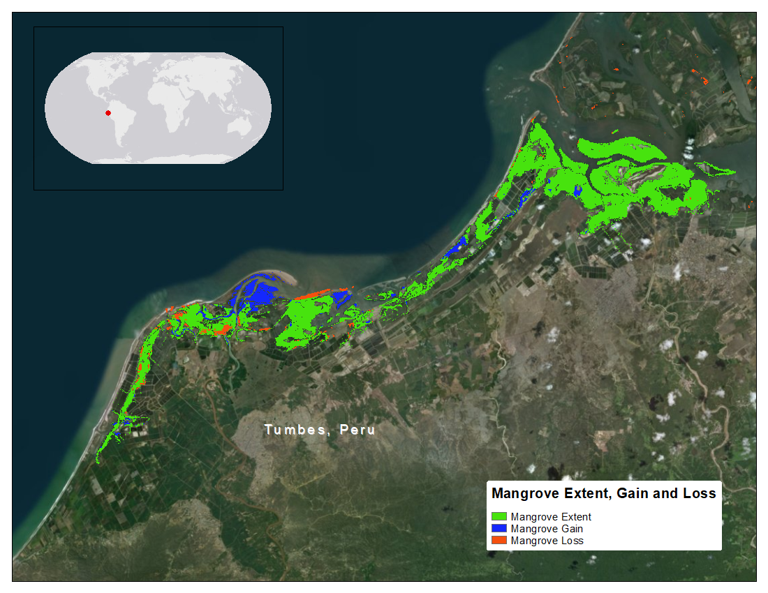
CMS: Mangrove Forest Cover Extent and Change across Major River Deltas, 2000-2016
National Aeronautics and Space Administration —
This dataset provides estimates of mangrove extent for 2016, and mangrove change (gain or loss) from 2000 to 2016, in major river delta regions of eight countries:... -
Federal
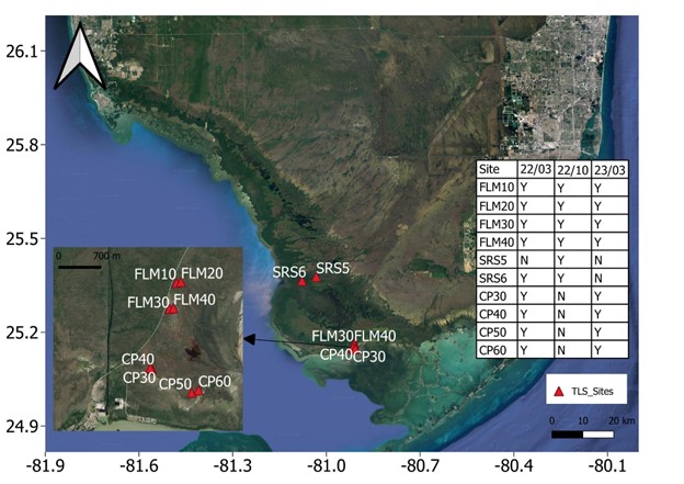
Blueflux: Terrestrial Lidar Scans of Mangrove Forests, Everglades, FL, USA, 2022-2023
National Aeronautics and Space Administration —
This dataset contains point clouds of three-dimensional (3D) mangrove forest structure and volume collected from 10 sites in Everglades National Park, Florida. Data... -
Federal
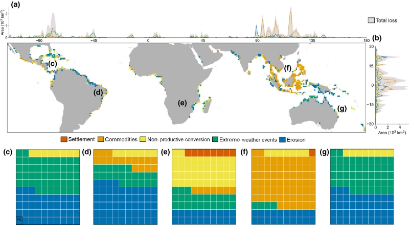
Global Mangrove Loss Extent, Land Cover Change, and Loss Drivers, 2000-2016
National Aeronautics and Space Administration —
This dataset provides estimates of the extent of mangrove loss, land cover change, and its anthropogenic or climatic drivers in three time periods: 2000-2005,... -
Federal
CMS: Mangrove Canopy Characteristics and Land Cover Change, Tanzania, 1990-2014
National Aeronautics and Space Administration —
This data set provides canopy height, land cover change, and stand age estimates for mangrove forests in the Rufiji River Delta in Tanzania. The estimates were...

Official websites use .gov
A
.gov website belongs to an official government
organization in the United States.
Secure .gov websites use HTTPS
A
lock (
) or https:// means you’ve safely connected to
the .gov website. Share sensitive information only on official,
secure websites.